Monday, September 18th, 2017
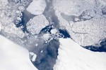
Operation IceBridge is flying in Greenland to measure how much ice has melted during the summer. The flights, which began on Aug. 25, 2017, and will go on until Sept. 21, 2017, repeat paths flown this spring and aim to monitor seasonal changes in the elevation of the ice sheet. “We started to mount these
Tuesday, September 5th, 2017
The impacts of Hurricane Harvey are being felt far and wide. As the rain continued to fall, and flood waters rose, an army of citizen-rescuers answered the call. And as governments encouraged citizens to help one another, the non-profit organization made up of mapping experts also answered the call. GISCorps, a program of the Urban
Tuesday, August 22nd, 2017
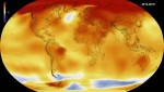
According to authors of a new study from the American Geophysical Union, it is “extremely unlikely” that 2014, 2015 and 2016 would have been the warmest consecutive years on record without the influence of human-caused climate change. Temperature records were first broken in 2014, when that year became the hottest year since global temperature records
Tuesday, August 15th, 2017
Sustainability data company Ecometrica called on countries and governments to adopt modern direct methods to measure climate-change emissions, following revelations by the BBC that official figures for emissions of climate-warming gases often are flawed, allowing some countries to underreport the level of pollution. “The time has come to move to direct monitoring of emissions and
Tuesday, August 8th, 2017
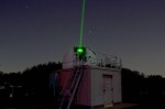
NASA and the Norwegian Mapping Authority are partnering to develop a satellite laser-ranging station 650 miles from the North Pole that will produce high-precision locations of orbiting satellites, help track changes in ice sheets, and improve the efficiency of marine transportation and agriculture. The Arctic station will be the latest addition to a global network
Tuesday, August 1st, 2017
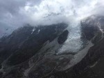
According to a new study published by USC scientists in the Proceedings of the National Academy of Science, rock and soil breakdown in glaciers generates more acidity and releases more carbon than other forms of natural weathering. Perhaps most interestingly, it is the elevated oxidation of pyrite, popularly known as “fool’s gold,” in the glacial
Tuesday, July 25th, 2017
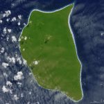
In the middle of the South Pacific Ocean, far from the urban, developed world, there’s a small, lush, green island with white sand beaches. However, this uninhabited, remote corner of the tropics—Henderson Island—also has a trash problem. The beaches of Henderson Island have the highest density of plastic waste in the world, according to a
Monday, July 17th, 2017
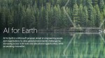
Land-cover mapping is a critical part of conservation planning, but current methods for collecting detailed geographic data are highly labor-intensive. Advanced technologies such as artificial intelligence (AI) can help, but they’re not yet widely accessible to those on the front lines of conservation and mapping. To improve this situation, Esri is collaborating with Microsoft to
Tuesday, June 27th, 2017
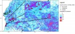
Satellites are helping to predict favorable conditions for desert locusts to swarm, which poses a threat to agricultural production and, subsequently, livelihoods and food security. Desert locusts are a type of grasshopper found primarily in the Sahara, across the Arabian Peninsula and into India. The insect is usually harmless, but when they swarm they can
Tuesday, June 20th, 2017
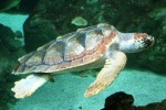
Loggerhead turtles are particularly susceptible to climate change as the risk of nest flooding increases and the health of hatchlings declines. Florida holds the world’s largest nesting population of loggerheads, yet little is known about the species’ activity in nearby Cuba. A recent article published in Chelonian Conservation and Biology suggests changing climate may
