Tuesday, May 1st, 2018
In the high-stakes race against sea level rise, understanding what’s causing the Greenland Ice Sheet to melt is critical. The problem isn’t just rising temperatures: soot from ships, wildfires and distant power plants, as well as dust and a living carpet of microbes on the surface of the ice, are all speeding up the melting.

Monday, April 9th, 2018
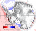
The European Space Agency (ESA) CryoSat mission revealed that, during the last seven years, Antarctica has lost an area of underwater ice the size of Greater London. This is because warm ocean water beneath the continent’s floating margins is eating away at the ice attached to the seabed. Most Antarctic glaciers flow straight into the

Tuesday, March 20th, 2018
Permafrost in the coldest northern Arctic—formerly thought to be at least temporarily shielded from global warming by its extreme environment—will thaw enough to become a permanent source of carbon to the atmosphere in this century, with the peak transition occurring in 40 to 60 years, according to a new NASA-led study. The study calculated that

Tuesday, March 6th, 2018
Manmade structures built along Chesapeake Bay shorelines to protect against sea-level rise, storm surge and erosion have been found to negatively impact waterbirds, according to a USGS study. In many coastal regions, shorelines are “armored” with wooden, concrete or steel bulkhead walls or riprap borders that consist of piles of large stones or boulders. Shoreline

Tuesday, February 20th, 2018
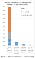
A new white paper developed by GTI’s Center for Methane Research (CMR) addresses questions regarding the impact of atmospheric methane in global warming—technically identified as radiative forcing—and what role fossil fuels play. The paper integrates greenhouse gas radiative forcing data from the National Oceanic and Atmospheric Administration, along with national and international annual greenhouse gas

Tuesday, February 6th, 2018
USC scientists have unlocked a new, more-efficient pathway for converting methane—a potent gas contributing to climate change—directly into basic chemicals for manufacturing plastics, agrochemicals and pharmaceuticals. In research published in the Journal of the American Chemical Society, chemists at USC Loker Hydrocarbon Research Institute say they have found a way to help utilize this abundant

Tuesday, January 16th, 2018
2017 will be remembered as a year of extremes for the United States as floods, tornadoes, hurricanes, drought, fires and freezes claimed hundreds of lives and visited economic hardship upon the nation. Recovery from the ravages of three major Atlantic hurricanes making landfall in the U.S. and an extreme and ongoing wildfire season in the

Monday, January 8th, 2018
NASA, the National Oceanic and Atmospheric Administration (NOAA), and the U.S. Geological Survey (USGS) should join forces to track changes in Earth’s temperature, according to a federally funded study on climate change. The three agencies should implement “a coordinated approach for their space-based environmental observations to further advance Earth science and applications for the next

Monday, January 1st, 2018
NASA scientists conducting research on the connection between fuel moisture and fires uncovered a paradox: a wet winter corresponds to more small wildfires in the following fire season, not fewer, as is commonly assumed. Large fires behave more “logically,” with fewer large fires after a wet winter and more after a dry one. “This is