
Tuesday, March 20th, 2018
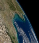
Permafrost in the coldest northern Arctic—formerly thought to be at least temporarily shielded from global warming by its extreme environment—will thaw enough to become a permanent source of carbon to the atmosphere in this century, with the peak transition occurring in 40 to 60 years, according to a new NASA-led study. The study calculated that
Tuesday, March 13th, 2018
Nutrient-rich ash from an enormous flare-up of volcanic eruptions toward the end of the dinosaurs’ reign kicked off a chain of events that led to the formation of shale gas and oil fields from Texas to Montana, according to a new study by Rice University geologists that appears in Nature Publishing’s online journal Scientific Reports.

Tuesday, March 6th, 2018
Manmade structures built along Chesapeake Bay shorelines to protect against sea-level rise, storm surge and erosion have been found to negatively impact waterbirds, according to a USGS study. In many coastal regions, shorelines are “armored” with wooden, concrete or steel bulkhead walls or riprap borders that consist of piles of large stones or boulders. Shoreline

Tuesday, February 27th, 2018
Code for Africa, the continent’s largest federation of civic technology and data journalism labs, and Radiant.Earth, a non-profit advocating for open geospatial data for positive global impact, announced their partnership to harness open Earth imagery and tools for improved decision-making as well as better insight and transparency. Their combined efforts will focus on research for
Tuesday, February 20th, 2018
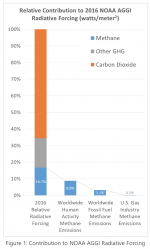
A new white paper developed by GTI’s Center for Methane Research (CMR) addresses questions regarding the impact of atmospheric methane in global warming—technically identified as radiative forcing—and what role fossil fuels play. The paper integrates greenhouse gas radiative forcing data from the National Oceanic and Atmospheric Administration, along with national and international annual greenhouse gas
Tuesday, February 6th, 2018
USC scientists have unlocked a new, more-efficient pathway for converting methane—a potent gas contributing to climate change—directly into basic chemicals for manufacturing plastics, agrochemicals and pharmaceuticals. In research published in the Journal of the American Chemical Society, chemists at USC Loker Hydrocarbon Research Institute say they have found a way to help utilize this abundant

Tuesday, January 30th, 2018
Sensors withstand extreme temperatures, pressures and aggressive chemicals By Will Meenan, Kaman Precision Products/Measuring It takes an extremely durable design to make reliable measurements in extreme conditions. Extreme environment position/displacement sensors perform where most sensors cannot survive. These sensors are designed to operate in the following environmental conditions: · High or cryogenic temperatures · Aggressive
Tuesday, January 23rd, 2018
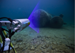
OceanGate Inc., a provider of manned submersible services, and 2G Robotics, which develops underwater laser scanners, formed a strategic alliance to capture laser data of the RMS Titanic shipwreck and debris field. 2G Robotics ULS-500 PRO underwater laser scanner will be installed on OceanGate’s Cyclops 2, the first manned submersible to survey the Titanic since

Tuesday, January 16th, 2018
2017 will be remembered as a year of extremes for the United States as floods, tornadoes, hurricanes, drought, fires and freezes claimed hundreds of lives and visited economic hardship upon the nation. Recovery from the ravages of three major Atlantic hurricanes making landfall in the U.S. and an extreme and ongoing wildfire season in the