 At the top of the planet, the cap of sea ice across Arctic waters grows and shrinks with the seasons, usually reaching its annual maximum extent in March. In 2026, this peak occurred on March 15, when the extent reached 14.29 million square kilometers, matching the lowest maximum observed since satellite monitoring began in 1979. One of the key areas contributing to the low maximum this year was the Barents Sea.
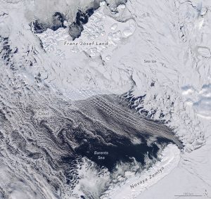
The Barents Sea lies at the periphery of the Arctic Ocean, bordered to the northwest by the Norwegian archipelago of Svalbard, and to the northeast and east by the Russian islands of Franz Josef Land and Novaya Zemlya, respectively. It is one of more than a dozen subregions—including the Central Arctic Ocean and nearby seas, bays, and waterways—across which scientists use remote sensing to track sea ice. The region is important for fisheries, shipping routes, and scientific research.
On March 17, 2026, the Terra satellite captured this image of the northern Barents Sea. Near Franz Josef Land, broken sea ice drifted near areas of open water closer to Novaya Zemlya. The region is often cloudy, as it was that day, but most clouds were thin enough to reveal the sea ice and water below.
In addition to the low extent, data from NASA’s ICESat-2 satellite indicate that Barents sea ice in mid-March 2026 was also very thin.
Image Credit: NASA Earth Observatory image by Michala Garrison, using MODIS data from NASA EOSDIS LANCE and GIBS/Worldview
