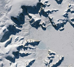
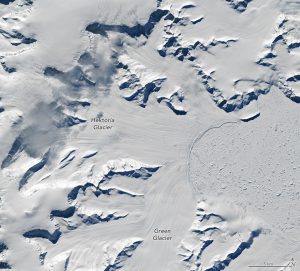
 Satellite observations are capturing the rapid retreat of Antarctica’s Hektoria Glacier, where ice loss has accelerated dramatically in recent years. The imagery reveals fractured ice, expanding melt zones and newly exposed terrain as the glacier continues to destabilize.
Scientists attribute the retreat to a combination of ocean warming and structural weakening of the glacier’s ice shelf. As the ice shelf thins and breaks apart, it allows inland ice to flow more freely toward the ocean, increasing the rate of ice loss.
Time-series satellite imagery provides a clear visual record of this change, showing how the glacier’s edge has steadily receded through time. These observations are critical for improving models of ice-sheet behavior and predicting contributions to sea-level rise.
The images above capture the scale of the loss of Hektoria’s grounded ice on the eastern Antarctic Peninsula. Note that the top image was acquired about one year after the remarkable loss of grounded ice; a cloud-free Landsat image showing the whole area was not available from the previous March. Hektoria’s terminus remained relatively stable after the sudden loss, the study reported, though the neighboring Green Glacier continued to retreat.
