 Unmanned aerial systems (UAS) have recently become ubiquitous in the mass media and in trade publications, due to a variety of factors that include : international controversy over their military use by the United States against targets in Pakistan; domestic concerns about potential privacy violations; the development of ever cheaper and more capable systems; congressional passage of the FAA Modernization and Reform Act of 2012, which mandated that the Federal Aviation Administration integrate UAS into the National Airspace System (NAS) by the end of September 2015; and a statement on television in December 2013 by Amazon’s CEO Jeff Bezos that his company is testing the use of UAS for package deliveries.
The future use of UAS for agriculture has featured prominently in this coverage because they have great potential to gather valuable data while privacy and safety concerns are minimal over farm land. According to a 2013 report by the Association for Unmanned Vehicle Systems International (AUVSI), the agriculture sector is expected to be the largest market for UAS technology, accounting for 80 percent of all commercial use. Farmers who read about UAS in agriculture publications or see them demonstrated at agriculture trade shows wonder how these devices could be useful to them and when they will be able to use one. Ongoing research and tests can already provide answers to the former question, while the answer to the latter depends on parallel developments in law and technology.
Satellite imagery has been used in agriculture for decades and continues to be very valuable for monitoring land use and crop health over vast areas. However, the resolution is too low to analyze fields in detail, often clouds hide parts of the imagery, and it takes a long time to receive the data after it is collected. The use of manned aircraft to collect aerial imaging can solve all three of those problems, but is expensive. Therefore, farmers have much to gain if UAS can enable them to capture aerial imagery of their fields frequently, cheaply, and at high resolution.
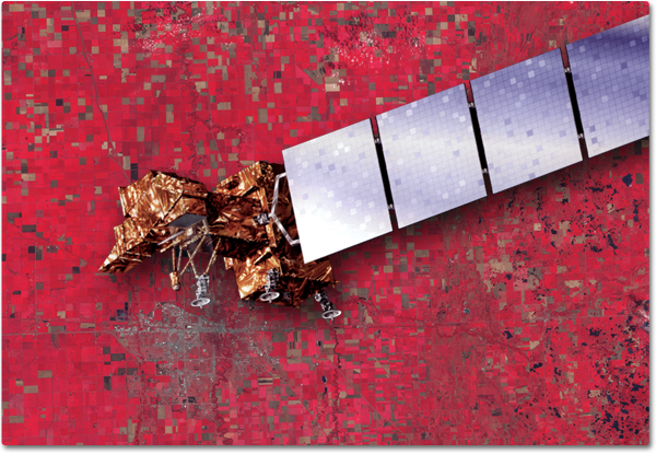 Near-infrared data collected by the Landsat 7 satellite, such as this image of Minnesota, can help farmers assess the health of their crops, however, for many this 30-meter imagery is too coarse to help with decision making. (Image courtesy of NASA).
Oregon’s Willamette Valley is one the country’s most important agricultural regions. Therefore it is not surprising that Oregon State University, located in the middle of the valley, in the city of Corvallis, is a hub of agricultural teaching and research. It has been experimenting with UAS at the Hermiston Agriculture Research & Extension Center (HAREC), its agricultural research facility in Eastern Oregon. Rick Spinrad, OSU’s Vice President for Research, is a strong promoter of the development of UAS for a variety of applications—including research on forestry, oceanography, land use, hydrology, glaciology, and geology.
He cites several ways in which UAS can benefit agriculture. The first is to monitor leaf health at high resolution and identify critical areas in need of additional water, fertilizer, pesticide, or herbicide. “Tied to that is soil moisture detection, which also helps in longer-term planning,” he says. “It gives you a sense of what the needs are going to be over the next several days because there’s a latency, if you will, to the drying out of the ground.” Additionally, he points out, the design and spectral characterization of a leaf-health sensor optimized to scan potato leaves will differ significantly from one used to scan a wheat field or a soy field or a corn field, “so there’s ample opportunity for demonstrating a variety of different applications.”
UAS can also help optimize tree planting and harvesting, Spinrad says, and could potentially be used to survey forested areas before and after major storms, to look at the impact of fires, and to help optimize planting for commercial forests, which are a major agricultural sector in the Pacific Northwest. Farmers could also use UAS as state-of-the-art scarecrows in vineyards, to keep away large flocks of birds that might otherwise devastate them. (Spinrad acknowledges, however, the challenge of outsmarting creatures that adapt quickly.)
The operators of large farms often put hundreds of dollars per acre into the field in inputs and use prescription maps and variable rate fertilization to match these inputs to soil conditions, which can vary significantly every few feet. The ability to monitor field conditions in detail during the growing season can allow these farmers to revise their fertilization rates frequently, thereby reducing costs and increasing yields. Additionally, farmers typically subdivide fields into work zones, which they may seed at different times, increasing the value of imaging them frequently so as to monitor areas that are in different phases of the growing cycle.
“Crop consultants see a real value in being able to know immediately the conditions of a field and illustrate to their clients what they are,” says Donald Effren, President of AutoCopter Corp., a company based in Charlotte, North Carolina that specializes in UAS for agriculture. “If you get long periods of rain and understand that you have to do some drainage work in parts of the field, you get a different perspective flying over it than walking it. If it is right after the rain, you can see and save an awful lot of production that you would otherwise lose because you know in a timely fashion what is going on.”
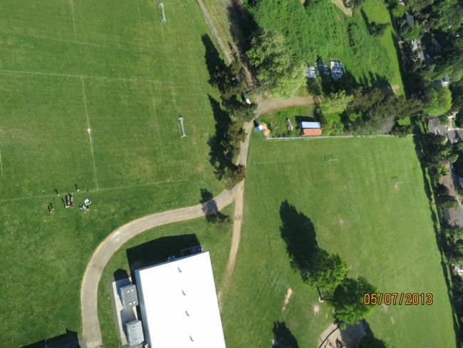 Imagery collected by a UAS exceeds the resolution of aerial or satellite imagery due to the flexibility of the platform to fly lower. (Image courtesy of Michael Wing).
Dozens of companies are developing or producing UAS, ranging in size from some that are smaller than a radio-controlled model airplane to some that have the same wingspan as a Boeing 737. Some are fixed wing aircraft, some are helicopters, and some are multicopters. All of these aircraft exist today in a state of regulatory limbo: they are neither specifically allowed nor prohibited from flying in most airspaces. Integrating potentially very large numbers of UAS into the NAS is a huge challenge for the FAA and for the aviation community because of the novelty of the devices, their rapid evolution, and the fact that this integration is taking place at the same time as the shift from ground-based navigation aids to a GPS-based system. It requires the establishment of airspace requirements, methods for ensuring the safe operation of UAS, integrating both military and private commercial UAS operations with air traffic control, and ensuring that the plan is in keeping with the FAA’s next generation air traffic plan.
Since 1990, the FAA has authorized limited use of UAS for such public interest missions as law enforcement, firefighting, search and rescue, disaster relief, military training, border patrol, and testing and evaluation. However, none of these operations are authorized in Class B airspaces, those with the highest density of manned aircraft over major urban areas. Recreational use of airspace by model aircraft is covered by an FAA advisory circular that generally limits operations to below 400 feet above ground level and away from airports and air traffic. In 2007, the FAA clarified that the circular only applies to modelers and specifically excludes individuals or companies flying model aircraft for business purposes.
Currently, there are only two ways to obtain FAA approval to operate a UAS. One way is to obtain an experimental airworthiness certificate for private sector (civil) aircraft to do research and development, training, and flight demonstrations. This type of certificate precludes commercial transport of people or cargo. The other way is to obtain a Certificate of Waiver or Authorization (COA) for public aircraft. COAs are available to public entities that want to fly a UAS in civil airspace, typically for one of the public safety, law enforcement, or military uses mentioned above. The FAA issues COAs for well-defined blocks of airspace and for specific time periods. As of the beginning of December 2013, there were 545 active COAs.
After a rigorous 10-month selection process in which it evaluated 25 proposals from 24 states, at the end of December 2013 the FAA chose six UAS research and test site operators across the country: the University of Alaska, the State of Nevada, New York’s Griffiss International Airport, the North Dakota Department of Commerce, Texas A&M University, and the Virginia Polytechnic Institute and State University. The University of Alaska proposal contained a diverse set of test site range locations in seven climatic zones as well as geographic diversity with test site range locations in Hawaii and Oregon. The research plan includes the development of a set of standards for unmanned aircraft categories, state monitoring, and navigation. Alaska also plans to work on safety standards for UAS operations. Each test site operator will manage the test site so as to give access to parties interested in using it.
Research and development on UAS is taking place in private industry, academia, and the military, sometimes through partnerships. At HAREC, for example, OSU has partnered with Seattle-based aerospace giant Boeing and with Paradigm, a company based in Bend, Oregon, that specializes in decision support systems for precision agriculture. “Boeing isn’t going to know what [farmers are] looking for in leaf-health and Paradigm isn’t going to have the flying experience that Boeing may have,” says Spinrad, “so the partnership there consists of OSU bringing the knowledge to the table and trying to provide new capabilities for industry which can be licensed. Then, if we get some royalties from that kind of relationship or some research investment by the company, everybody wins.”
At OSU, the faculty members involved in UAS-related research can be divided into two groups, Spinrad explains. One group consists of researchers, such as those in agricultural sciences, who are applying the data collected by the UAS and do not care much about the characteristics of the platforms and how they are flown. The other consists mostly of engineers and physicists, who are very interested in the air frames, the sensors, and the signal-processing. “The exciting part has been bringing these two groups together.”
Michael Wing, an Assistant Professor of Geomatics in OSU’s College of Forestry, currently spends a lot of his research time thinking about UAS, trying to arrange for flights, and then working with the data collected. “I think we have 12 COAs right now that are approved and another four that are in the review process,” he says. “My research applications for UAS are centered within forestry, but also include agriculture. We have one COA right now that is in the review process that will apply to two different vineyards and we will be filing another COA for a third one. We will be working with a combination of visual imagery and near-infrared, which will allow us to say something about vineyard vigor, which is the production capacity and quality of the grapes that are coming out of these vineyards.”
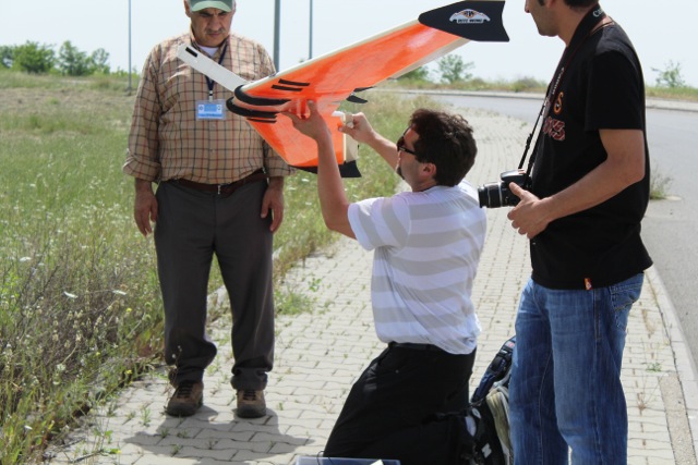 Michael Wing and colleagues at OSU’s College of Forestry prepare to launch a fixed wing UAS.
“The UAS that I am most proud of is, of course, the one that we built in-house for less than $2,000,” Wing says. “We buy a piece of foam in a fixed wing configuration that we call a blank. It has some cut-outs, but we do a lot of hacking on it to fit all the components that we selected. We buy all the components individually—everything from the battery to the camera to the voltage regulator to the GPS receiver. We either glue or screw or otherwise affix these components together and fly.”
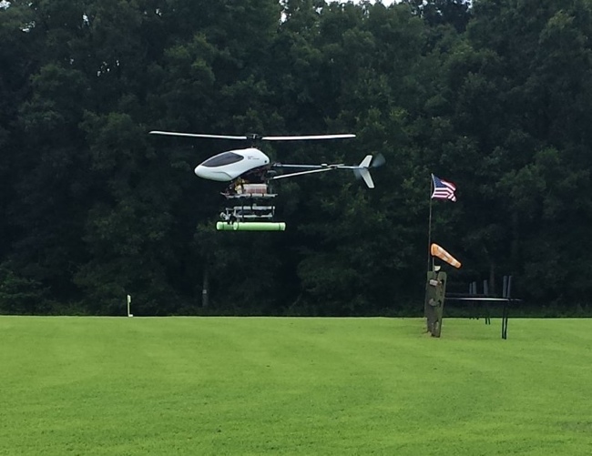
They have also bought kits that had to be assembled, including a hexacopter, and are having a helicopter built for them. The helicopter will cost $15,000, plus another $20,000 for navigation equipment and $30,000 for a Velodyne lidar sensor that they are hoping it will carry. It will fly manually and Wing expects it to be capable of 30 minutes of flight time. “We are very excited about being able to do lidar flights,” he says. The lidar sensor, which was designed for light weight applications, is a little larger than a soda can, weighs about two pounds, and puts out about 300,000 pulses per second. It could collect tens of thousands of points per square meter on the ground. “The amount of data will just be overwhelming. We’ll probably spend a lot of time figuring out just how we can minimize the amount of resolution we have.”
AutoCopter Corp. has developed a helicopter that automatically takes off, follows a pre-programmed flight plan, flies for up to two hours between refuelings, and lands at the touch of a button. “You can lay out what you want to cover before you get to the field because it works with Google Maps,” Effren explains. “When you set up the parameters, the software will tell you how many zigzag patterns you have to make based on the camera’s field of view to capture the data.” By reusing a flight plan, a farmer can fly the same route at the same height, speed, and altitude for direct comparison.
The helicopter takes three types of imagery simultaneously—multispectral, DSLR, and HD video—at a one inch resolution and records the data on memory cards. After it lands, the user recovers the memory cards, inserts them into a ground control station in the field, and can immediately see geo-referenced images. The ground control station also processes the raw data and generates multispectral images in less than a second per image and can convert them into the GeoTiff format for export directly into farm management programs and variable rate prescription maps. “So, if you want to, you are able to make decisions the same day,” says Effren. The helicopter can fly at speeds from 10MPH to 30MPH. “I have yet to meet someone who has more than 1,000 acres who looked me in the eye and said, ‘I cover every inch of my field.’ You physically can’t.” The company sells the complete system for about $90,000.
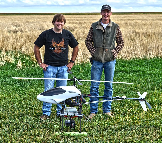 AutoCopter’s AC-G15 along with two trained pilots. The system can fly a variety of different sensors at different heights, returning multispectral, DSLR, and HD video at a one inch resolution.
Current FAA regulations allow farmers only very limited ways to use UAS. “It’s not unlike buying one of the Brookstone Parrot drones and trying to use it over your garden plot,” says Spinrad. However, he points out, probably very few farmers will buy UAS anyway. Rather, due to the operations and maintenance costs and the licensing requirements that the FAA is likely to impose, it will be contractors who buy and operate these aircraft, analogously to crop dusting contractors.
“I don’t think the FAA is going to soften the requirements with respect to the licensing of UAV operators and in fact I would encourage a rather rigorous licensing process.” Moreover, he argues, the UAS industry has not yet developed a robust capability. It’s going to take as long for the R&D to develop to a point where a commercialized capability exists—when a farmer could buy an off-the-shelf plant health system and go out and fly it himself—as it will for the FAA to issue the rules integrating UAS into the NAS.
Wing agrees that the integration of the technology will be led by consultants and contractors, who will not only own and operate their own aircraft but also handle the data. “Outside of handing off the color imagery,” he foresees, “they will be the ones that handle getting the imagery from the sensor to a hard drive someplace, where it can be corrected and assembled so that it is useful. I think their typical delivery packet will be color imagery, which will help farmers quite a bit, at least in identifying areas that probably deserve a little closer attention. Another product will probably be near-infrared and various indices that pull out some of the strengths of infrared, being able to detect whether vegetation is flourishing and growing. Usually, that means moisture stress or something else that set in some leaves or pest infestation. On that IR side, that is going to take a little more the analytical power of consultants.”
However, Wing is convinced that turn-key solutions will follow close on the heels of the contractors. “Maybe three years after the contractors are showing farmers that this imagery that they are collecting and passing on has tremendous value, you will start to see these farmers developing their own capabilities. They will be able to buy a small UAS for maybe $1,500 that doesn’t require any tweaking or cutting or gluing. Maybe they will spend a little more on the camera and, with the aid of software, they will be able to do their own flights, do their own image processing and corrections, and be able to serve themselves.” This industry is going to mature rapidly, Wing predicts, as a growing number of manufacturers get involved and target people who don’t have aeronautics degrees and want something that they can pull out of a box and fly that day reliably. “Five years from now,” Wing concludes, “the skies are going to look remarkably different and these vehicles will be prevalent.”
