 Unmanned Aircraft Systems (UAS) are advanced robots that will empower many citizens and professionals. In a report published by the McKinsey Global Institute, it is estimated that a potential economic impact of $14 – $33 trillion a year by 2025 from the 12 technologies discussed. One of those technologies is advanced robotics: robots with enhanced “senses” and intelligence increasingly capable to perform tasks once too dangerous or uneconomical to automate. UAS and microsatellites are a prime example of “advanced robots” that will empower citizens and professionals and give them unprecedented access to the national airspace to surveil, remote sense, and map the entire globe.
Today our national airspace (NAS) is accessible to only manned aircraft and a little over 600,000 active pilots. That’s less than 0.1% of the population. UAS and its enabling technologies (miniaturization, wireless communications, and location) will help eliminate the barriers to entry of the NAS. Many very capable robots will cost as little as $300. Pilot certifications for flying UAS may not be required or will become much easier to obtain. As more people and businesses have easier access to the NAS, it will, for the first time, become a “platform” from which will spring a profusion of activities and professional services that have not been possible to date.
Regulatory delays remain a significant barrier to the rich, rapid innovation promised by UAS. The FAA released its annual UAS roadmap for 2013 in November. It does not anticipate full sUAS integration into NAS until 2020. It remains unclear when larger UAS will achieve full integration despite the law’s mandate of 2015. Additionally, privacy concerns have burdened an agency historically focused on “safety” with extraordinary legal and cultural issues that the agency has no legislative mandate to address. The longer robust civil use of UAS is delayed the more chimerical the predictions of economic activity become.
Despite regulatory uncertainty, the incredible innovative energy of UAS manufacturers and users is clearly making tracks. Ground-based autonomous data machines have been developed that are much smaller than a man and are equipped with GPS, 3d LiDAR mapping, 360 HD video, thermal imaging, night vision, OCR, audio recording, and biological-chemical-radiation detection. This sensor, or one similar, will eventually fly.
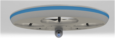 The AEVA from Olaeris is a first response UAS designed for emergency responders to save lives, protect property, and serve teh public without encroaching on constitutional rights or civil liberties.
Aerial robotic technologies are flourishing. It was only a matter of time, but UAS are advancing rapidly to the point where military experts are contemplating aerial dogfights between unmanned systems within 15 years. This may render manned aerial combat obsolete.
The good news for the geospatial profession and the UAS industry is that this same warring technology using robust sense and avoid systems will be exploited in the civil space for peaceful applications. Sense and avoid technology is an array of sensors, communication tech, and procedures that will be integrated into most UAS before full NAS integration can be achieved. Right now it is recognized that we need a man in the loop when flying unmanned systems. But the question facing the FAA and UAS industry before full integration of UAS can occur is what kind of redundancy and fail-safe tech and procedures are required for unmanned systems to fly with commercial air traffic especially, and how problems with the operation of the aircraft will be mitigated when they occur.
The first big civil uses of UAS will be with small UAS (<55 lbs). sUAS are flourishing today for research and for emergency management purposes around the country by public entities. We may see in 2014 the first “exemptions” granted by the FAA for the commercial use of these robots over non-populated areas under line-of-sight rules outside of the special Arctic Zone. The most important initial applications of sUAS will undoubtedly include agriculture, mining, construction and infrastructure inspection, storm tracking & environmental monitoring, firefighting, and wildlife monitoring. Other early uses will include hazmat detection, real estate photography, amateur photography, and surveying and mapping.
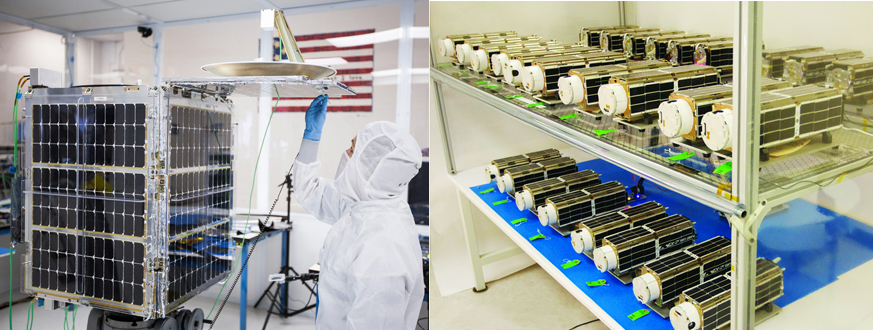 The Skbox Skysat-1 satellite (left) achieved orbit in November 2013, and a flock of microsatellites called “Doves” from Planet Labs are expected in orbit in December 2013.
sUAS activities that have recently occurred or are occurring are indicative of a growing interest in an important technology. Commercial and research flights of sUAS have begun in the new Arctic zone off the coast of Alaska. UAS are being used here so NAS stakeholders can learn how to safely operate unmanned aircraft beyond the line of sight anytime day or night.
The Unmanned Vehicle University in Phoenix has opened. This is, so far, the only University in the world licensed to grant Doctorate and Master’s Degrees in Unmanned Systems Engineering. Many more Universities now include UAS studies and degree programs, e.g., the University of North Dakota, Kansas State University, Embry-Riddle Aeronautical University, and Indiana Statue University just to name a few.
Remote sensing microsatellites are now operational and in orbit. The Skybox Skysat-1 achieved orbit in November. This satellite, about the size of a small refrigerator, will capture imagery with about 1m GSD. Planet Labs is preparing to launch the largest ever constellation of Earth-imaging satellites later this month. The 28 “Doves” (only 12” by 4” by 4”) will be in low orbit (~400 km) beaming 3-5m GSD imagery to earth. Microsatellite customers will be able to purchase and task “fresh” satellite imagery of nearly any location on the planet several times each day using a cell phone.
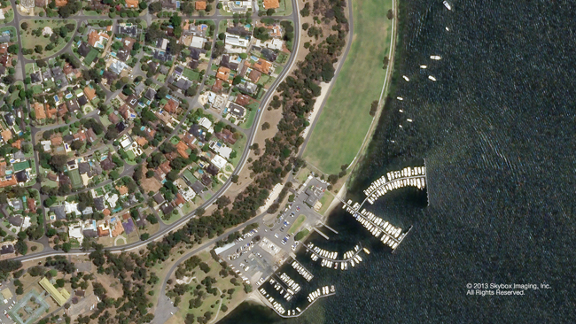 One of the earliest sub-meter GSD images from Skysat-1 now in orbit.
A very active DIY community, diydrones.com, has developed. There are concept UAVs at Sandia Labs that can fly, swim, drive, and even hop across any terrain. Manned aircraft are being retrofitted with unmanned systems. Indoor positioning is now practical and opens a whole new realm for remote sensing and UAS. Venture capitalists are now actively in the game of funding UAS companies. Lastly, large geospatial firms like Woolpert and Merrick are already performing sUAS services and partnering with UAV providers.
“Personal remote sensing” will become very important. Today, only hobbyists are able to do their own remote sensing on the cheap. But UAS technologies will enable a broad swath of citizens and businesses to conduct their own remote sensing with sophistication that is only possible today with large capital investments. Farmers, orchardists and other high value crop growers, railroads, mining sites, construction companies, journalists, and many citizens will own their own single-purpose, fully automated sUAS. These aircraft will not only fly themselves with a simple upload of flight plans but also deliver geospatial data (orthos, DEMs, NDVI, 3D imagery, etc.) and instructions to their tractors, pesticide sprayers, harvesters, flying cameras, or home PCs, etc.
Within a decade sense and avoid technology will enable larger aircraft to be integrated into the NAS. This “sensing net” around each aircraft, built atop the NextGen air traffic control system now being built, will be instrumental in enabling the efficient and safe operation of manned and unmanned aircraft in the same 3D space. As these robots take to the air, we will see air cargo companies like UPS, FedEx and DHL move freight across the globe in unmanned aircraft. Jeff Bezos’ vision of Amazon packages delivered to our doorsteps via UAS will become a reality. Perhaps, unmanned personal air taxis that pick up and deliver riders door-to-door is not a stretch. Imagine the possibilities of “personal air travel” if a small 1-4 person unmanned aircraft could be dispatched to pick you and your date up for ride to a party 90 miles away as easily and inexpensively as today’s taxi, and get you there and back more safely than the best driver on today’s highways.
On the dark side of this coming revolution, the innovator’s dilemma may doom many of today’s “aircraft makers” and remote sensing providers to play virtually no role in manufacturing or operating the millions of next generation UAS. The forces of innovation and brilliance may foster a whole new industry unhindered by the economic models of today’s business environment to build, service, finance, insure, and operate UAS. Consider also that sales of traditional piloted aircraft may decline precipitously … or at least, unmanned systems sales may grow to dwarf anything ever seen with piloted aircraft.
 The Jetsons personal air transports are not unrealistic after sense and avoid technology is available for all UAS.
Unmanned, intelligent vehicles will be designed for specific applications and will come in many unconventional shapes and sizes. Imagine everything from specialized long endurance surveillance craft to swarms of credit-card sized flying “mobile phone cameras” communicating with each other and imaging (in 3D) an agricultural area or the inside of an office building in a few minutes at any resolution. Aircraft design would no longer be constrained to fit the human body. Flying, sensing robots will look like insects, maple seeds, flying credit cards, Frisbees, and 8-rotor vehicles. Things that shouldn’t be able to fly will wiz by…maybe a whole swarm!
More specialized and capable unmanned remote sensing platforms will be built. Continual refresh of areas of change will become an “expectation” of users of remotely sensed information. The demand for high resolution data (imagery and elevation) will continue to grow and the price of each pixel and point will fall. Long endurance, persistent surveillance for many types of applications will become a new market for many businesses. Remote sensing in high risk areas like dangerous tidal areas, within hazardous storm systems, in poisonous environments, and near threatening humans and animals will become commonplace and much more affordable.
Specialized vehicles will enable remote sensing companies to task their UAS for other firms based on the vehicles current location. Why fly it back home or leave it on the ground for 2 weeks until the next job if another firm can upload a flight plan and put it to use? These UAS “Zipcars” will provide higher utilization and lower costs. Interestingly, insurance costs for many new “remote sensing” specialists will not be needed since they are no longer operating the remote sensing platform. It remains to be seen if aircraft insurance costs decline for remote sensing platforms that may prove to be more safe and reliable and have no humans on board.
With smaller, specialized remote sensing platforms sensing will become much easier, faster, and economical. Today if 30 flight lines are needed to cover an area, a single manned craft is flown down each flight line, makes wide turns and starts down the next. But with small unmanned “flying cell phones” operators may release thirty out to fly together like a flock of synchronized birds and acquire the entire area in just one strip in 1/10th the time.
 Many small and large UAS will not need airports and will be much easier to operate for businesses and individuals.
Many UAS will not need airports. In fact, they will be purposefully designed to avoid them and will safely take off and land virtually anywhere, even from our office rooftops or in our parking lots. Maybe cities will provide safe, lightly administered “landing zones” so UAS use is encouraged and their economic benefit realized.
It is more difficult to envision the other myriad spin off services in the related markets of surveillance or communications. We have only begun to consider the number of problems that can be solved and the possible business opportunities capable of exploiting high resolution data sets of geographic areas inexpensively surveyed repeatedly every hour, day, week, or month?
As stated earlier, the real take-away from the coming UAS technologies is understanding how the National Air Space will become a “platform” for innovation and business. The NAS platform will have low barriers of entry so any business or individual can safely exploit it to solve problems with significant economic value. Remote sensing and big data about “place” is about to make a quantum leap forward because of this “NAS platform”.
As ubiquitous remote sensing becomes possible why wouldn’t Google or Microsoft market the near real-time updates to every city and county, and to pipeline, mining, and utility companies in exchange for the use of this data in their “globe” products. They could become the source of “engineering scale” remote sensing data for a large portion of today’s markets. Microsoft has already engaged in this type of effort albeit to a much smaller scale and at considerably higher cost via the Clear30 program. UAS will only make this more practical and economical.
Regulation is still a real threat and the biggest constraint to the adoption of this transformative technology. Always the optimist, it is more likely that the powerful economic forces inherent with this enabling technology will pressure the social and political forces to get out of the way.
 Unwise, choking regulations remain an important threat to the economic potential of UAS.
Many anti-UAS privacy advocates today want us to envision a future of dark, stealthy, armed birds of prey circling over every American city ready to infringe on all. This type of alarmist rhetoric is consistent with the introduction of disruptive technology in society. It has happened many times in the past. People fear the “worst”. Our growing distrust of a powerful and increasingly inept government feeds this fear of repressive security measures.
Although that vision is ridiculous, geospatial professionals are advised not ignore these concerns and instead should address them head on. Professionals need to counter this view by advocacy in public policy and with the adoption and promotion of safe, responsible UAS use. We need to foster transparent data collection and honest data minimization standards that ensure private data is not collected, or when it is collect, how and when it will be destroyed or anonymized.
Data is power. UAS operators will have sensors and sensor networks with tremendous data acquisition, synthesis and analysis capabilities. The public will need to see our profession use this technology responsibly and understand that their privacy is credibly safeguarded. As Bruce Schneier says “Data is the pollution problem of the information age.” The threat to personal privacy of this “pollution” is real because of the technology’s growing relevance and ubiquity.
The number of new opportunities in the coming UAS economy is breathtaking. There remain many regulatory obstacles that threaten the robust maturation of this disruptive technology. There will be winners and losers among geospatial and remote sensing firms. Existing providers can remain relevant, but they must profitably transition to the new paradigm and leverage the “NAS platform” to extract new value from points and pixels. The best firms will recognize and capitalize on the many new opportunities made possible by the NAS platform of UAS.
Be sure to read the first two installments of this three-part series, if you haven’t already:
