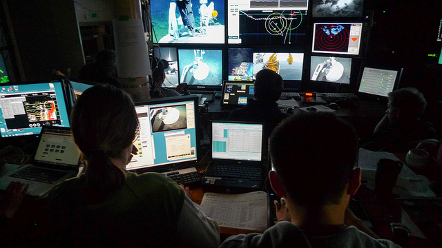
 The advent of Earth-observation satellites transformed how we view our planet—from occasional snapshots to near continuous, comprehensive, and real-time coverage. Likewise, the advent of cabled sensor networks on the sea floor is beginning to provide scientists and the public with a continuous flow of data, including video streams, that will revolutionize our understanding of the oceans.
The University of Victoria, British Columbia, Canada, has set up two such cabled networks as part of the Ocean Networks Canada (ONC) Observatory: the NEPTUNE regional ocean network, in the Northeast Pacific, an 840 kilometer-long telecommunications cable that spans ocean environments ranging from the rocky coast to the deep abyss, and VENUS, a coastal network in the Salish Sea, which includes a fjord sea inlet, and in the Strait of Georgia, which is bustling with economic activity. Both deliver information from seafloor instruments to the university via fiber optic cables. In the United States, the Ocean Observatories Initiative (OOI), funded by the National Science Foundation, began deploying its first global infrastructure site in the Gulf of Alaska in July and will begin partial deployment of arrays off the Oregon coast in October.
While the scientific payoff of these networks is enormous, so are the technical challenges of operating in an environment that is inherently hostile to electricity and can only be reached with very expensive and highly specialized vessels and equipment.
The NEPTUNE and VENUS projects are focusing on four science areas, says Kate Moran, ONC’s president. “The first is broadly about understanding human-induced change in the northeast Pacific Ocean, including such questions as the magnitude and rates of change occurring, how the ocean ecosystem will respond to increasing acidification, and how it changes with depleted oxygen. The second is understanding the range of life in the environments of both the northeast Pacific and the Salish Sea, which spans from chemo-synthetic life at hot-vent areas to life deep beneath the sea-floor. The third is all about the fluxes. For example, how does 350 degree, mineral-rich water released into the ocean from the sea floor influence oceanographic conditions?”
“The fourth,” Moran continues, “is all about the sea floor in motion; trying to understand the tectonic environment, both at the micro scale and the underwater landslide regime.” Should those landslides occur in a large extent, she points out, they could not only take out important infrastructures, such as the ferry terminal and the airport, but could also cause local tsunamis. “We’re also trying to understand the tsunamis generated, their impact on the coastline.”
Having cameras and sensors on the bottom of the ocean continuously—in the Saanich Inlet they have been there for more than seven years—is scientifically very interesting. “We’ve seen things that we never expected to see at all these sites,” says Ken Denman, ONC’s Chief Scientist and a professor at the School of Earth and Ocean Sciences at the University of Victoria. “The ability to, for example, talk about something to a class while you’re actually looking at what is going on in the water is very exciting.”
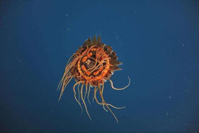 An unusual jelly observed over Endeavour at a depth of 1970m. Credit: Ocean Networks Canada
One urgent scientific question, says Denman, is the dropping pH level, which makes the ocean more acidic. “The ambient oxygen seems to be decreasing over the last few decades. That means that the part of the area of the continental shelf that is habitable by near bottom animals is shrinking. One of our key products is monitoring oceanographic variables that are relevant to climate change for a long time. We’re very anxious to start monitoring pH.”
ONC also conducts special experiments, in which groups of scientists collaborate intensively for a period of time. “Right now we have a bottom boundary layer experiment,” says Denman, “where we have physicists with acoustic sensors, optical particle sensors, and special sensors for measuring water velocities near the bottom working to understand how current in turbulent environments affects the sediments and the organisms living on or near them.”
In the United States, OOI will provide “sustained measurements of many, many ocean properties for decades, with the idea of having uninterrupted time series of data, from the sea floor to the sea surface in many locations,” says Tim Cowles, vice president and director of OOI’s Ocean Observing Programs. “That’s something that on a sustained basis has never been done very well in the past. OOI is designed to be a flexible infrastructure to support research into many different kinds of science questions—including sea-floor geological processes, ocean circulation, interaction of the atmosphere with the sea surface, and issues of ecosystem health and dynamics along the coastlines. The urgent scientific questions are only answerable because of the sustained time-scales of measurement and the new picture of processes that OOI allows us.”
The infrastructure for NEPTUNE and VENUS is divided into three components, explains Adrian Round, director of ONC’s Observatory Operations. “There’s the shore-based infrastructure, where the cables physically come ashore and shore stations that house the power systems, connections to utility power, and network connections. The data-archiving and collection infrastructure is predominately here in the University of Victoria. The sub-sea infrastructure then starts out with the primary infrastructure, the ‘backbones,’ and they’re all telecommunications technology.”
The ‘nodes’ on the backbones are like underwater versions of the LAN ports in an office. “They take the power from the backbone cable,” says Round, “convert it to a voltage that’s useful for science instruments, and host the network equipment that allows us to essentially build an underwater Internet. VENUS operates in shallower water, so its nodes only go down to 300 meters. NEPTUNE works in the much deeper ocean, so the nodes go down to almost 2,700 meters. Each node has a lot of complicated electronics and parts in it, so we designed them such that we can get them back relatively easily for maintenance and upgrades. The frame of the node is hard-wired to the primary infrastructure and stays on the bottom. All the active electronics and things that might break or want to be upgraded over time are in a removable pod.” These pods can be recovered and re-deployed by a remotely operated vehicle (ROV).
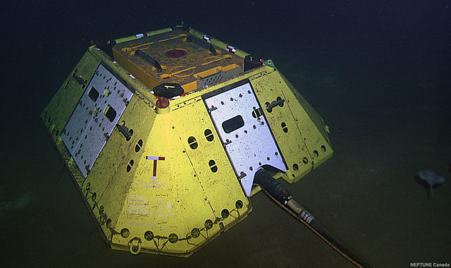 Endeavour node as it appeared one year after installation in 2009. Credit: Ocean Networks Canada
The layout of the nodes fixes the network’s sub-sea-bottom footprint. Each node only has a limited number of science ports—currently four on NEPTUNE and eight on VENUS. “If you were to just plug a single instrument into each one of those ports, you’d very rapidly run out of ports,” Round points out. Therefore, junction boxes break the power out into six to ten different connections; in turn, these junction boxes can be connected in series. “Once the data arrives at the shore stations, it is buffered so that if we lose our terrestrial backhaul links to the data center here at the university we don’t actually lose data. Once the data arrives at the data center, we parse it correctly, archive it, and then make it available through Web portals to anyone that needs it.”
ONC’s digital infrastructure is “probably the best in the world for collecting data,” according to Moran. “A lot of that is video. We have developed software that allows you to go in and look at everything from serial kind of data, like time series of temperature, all the way up to searching our database and videos for pictures of crabs, or pictures of gas bubbles, etc. On the primary infrastructure side, we have a fairly reliable backbone cable and data systems. But the secondary structure is challenging, because we have to be able to lay cable in deep water in areas. Some, like Endeavor Ridge, are really challenging because there are sharp edges everywhere on the sea floor.”
OOI includes fixed and robotic devices and a cabled sea-floor system. It will cost $386 million dollars over five and a half years and is “the most ambitious and broadest in scope” among such projects around the world, according to Cowles. The first deployments were in July, in the Gulf of Alaska; partial deployment of arrays will occur off the Oregon coast in October and in New England in late November. “Then an extensive array of coastal and global installation of instrumentation will be deployed in 2014, including instruments and platforms plugged into the submarine cabled system that’s been deployed over the Juan de Fuca tectonic plate west of Oregon and Washington.” In August or September, preliminary data will start being available to anyone through the OOI Web site. “So, over the next year things are going to be cookin’.”
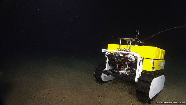 Wally the Crawler on the seafloor. Credit: Ocean Networks Canada
NEPTUNE and VENUS include a vast array of oceanographic sensors—ranging from commercial off-the-shelf devices that the oceanography community is used to and deploys all around the world to unique instruments that capitalize on the benefits of cabled observatories, which is a lot of power and a lot of bandwidth, such as high-definition TV cameras, lights, pumps, sonar systems, and remotely-operated crawlers. They measure temperature, salinity, conductivity, pressure, CO2, methane, and many other variables. “We also have various types of passive and active acoustics, so we hear whales, we hear a lot of vessels,” says Denman. “We also have bottom-mounted acoustics sensors looking upwards that give us information on the vertical migration of large zooplankton.”
Additionally, the networks have a wide range of sensors, such as seismometers, that monitor the sea-floor. “We have pressure recorders that measure tsunami waves,” says Moran. “We have accelerometers, and then there’s a whole range of more complex instruments that use acoustics. We even think that we’re able to see small salmon fry in those complex data. Then we have still cameras and video cameras on the network, as well as active instruments, like Wally, the crawler, which crawls on a hydrate mound and is controlled by a site in Germany. We have sensors that capture samples of fluids over time based on event detection and other ones that are automatic. In VENUS, we have installed other kinds of sensors to complement the sub-sea-floor cabled infrastructure. We installed CODAR [a surface-based radar system] in the vicinity of Vancouver, which allows us to provide near real-time surface currents. We also have been putting sensors using flow-through ocean water on the ferry systems that cross the Strait of Georgia.”
“The marine operations group at ONC works with the scientists to determine the requirements of their research goals and help them design the instrument packages or these unique devices that will help them get their data stream,” says Round. “We take instruments that were designed for short-term deployments and do pretty major modifications on them, so that they can be just plugged in and live in an ocean environment for long periods of time,” Moran points out.
Of course, the scientists are eager for further development of underwater instruments. “We don’t have good sensors for all of our applications,” says Moran. “For example, we don’t have a good mass-spectrometer that can be plugged into a cabled observatory. That would be critical for understanding the gases that are associated with things like gas hydrates and other chemical changes in the ocean. Currently we don’t have a distribution of pH sensors on the network because they are not yet stable and they are not yet designed for deep water and long-lived.”
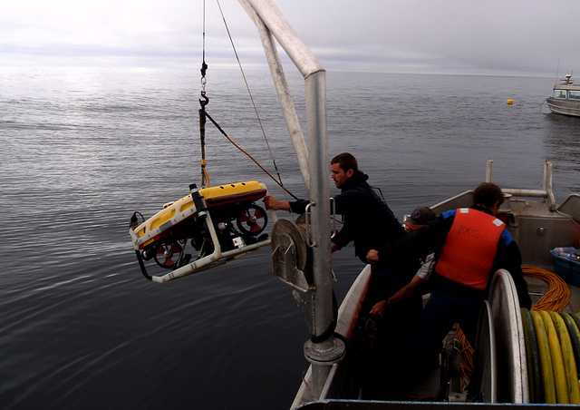 Mike Dennis (left) Josh Chernov and Glenn Hafey (right) lower the remotely operated vehicle (ROV) Seaeye Falcon into the water from the M/V Crown Royal during installation operations at Folger Pinnacle, 30 August 2012. This ROV and ship are operated by Ocean Dynamics Canada. Credit: Ocean Networks Canada
In addition to the instruments in fixed locations and Wally the Crawler, to improve the arrays’ spatial coverage ONC is deploying gliders, AUVs (autonomous underwater vehicles), and vertical-profiling systems that bring instrument packages up and down through the water column.
Gliders are buoyancy-driven, using a bladder with a small hydraulic pump. “They’re very carefully balanced,” Round explains. “They have wings. When a glider wants to dive, it sucks the oil out of the bladder and becomes negatively buoyant, then it shifts a trim-weight forward and creates a nose-down pitch. To surface, it pumps oil into the bladder and becomes positively buoyant, it pitches the nose up and flies upward. A small onboard inertial system keeps it pointed in the right direction and commands turns. It’s given a map to follow and essentially, by repeatedly diving and surfacing and changing this trim-weight, it flies. The gliders are very energy-efficient, so they can cover a wide area.”
By contrast, AUVs are powered, so they run much shorter missions. However, they can maintain depth and can be pre-programmed to do searches. Like gliders, AUVs are autonomous; they both differ from ROVs (Remotely Operated Vehicles), which are typically tethered to a surface ship and commanded by a pilot on the ship. “An AUV is programmed like a glider and goes off and does its mission and then comes home,” says Round. “Once it starts, you typically don’t interact with it. But because it has a motor in it, it’s able to follow more accurately a programmed path. It tends to have a much shorter range than a glider and a much shorter mission duration. Gliders and AUVs can then run missions and give you a better sense of what’s bounding your fixed bottom array.”
“We have bought one glider and we’re just in the process of testing it,” says Denman. “We also have a vertical profiling system that we’re probably going to deploy within the next two months in Saanich Inlet. It will have sensors that will go up and down from the bottom near 200 meters several times a day.”
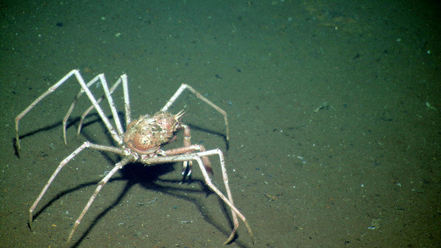 Spider crab observed at a depth of 2274 m. Credit: Ocean Networks Canada
The ocean is a hostile environment for cabled networks—due to pressure, corrosion, abrasion, and sea floor movement. “Anything under water is complicated, especially in salt water,” says Cowles.
Deploying the primary infrastructure requires dedicated cable ships. “It’s a very specialized operation deploying these cables in deep water, getting them in the right place on the bottom with the right tension, and putting them down in such a way that they’re going to last twenty years,” says Round. “Occasionally, they do fail. For example, due to a submarine landslide, a cable abrades because it’s been suspended over some rocks. Some of the places where we lay the cables are fairly nasty, but they’re where the scientists want to be. If a cable breaks, you have to bring in a cable ship, recover the cable from 2,000 to 3,000 meters of water, bring the ends to the surface and splice repair sections in. We leverage the existing telecommunications industry infrastructure with regards to cable ships and things like that.”
“In order for the data streams to be valid, most instruments need to be calibrated from time to time,” Round continues. “So, we plan maintenance cruises throughout a year where we take an ROV system on to a research vessel, go down to each of the sites, disconnect the instrument packages, bring them to the surface, replace instruments, clean them, deploy new ones, and then put the packages back down. In NEPTUNE, if an instrument fails it could be a year before the maintenance cruise is available to go and get it back. ROVs have two arms, have limited reach, have certain limits in dexterity, and have to fit on research vessels. So a lot of thought goes into the design of the platforms and the whole maintenance operations.”
“Technical challenges successfully met by OOI,” says Cowles, “included putting a complex cabled network on the sea floor with 10 kV at the beach and building all the step-down transformers and power conditioning that are required to deal with the different kinds of instrumentation that will be on the sea floor.”
ONC faces the additional challenge of being the first agency to deploy a network of this kind. “We’ve encountered a lot of problems that were not anticipated,” says Denman, “and we can’t go to other people and say, ‘What did you guys find?’”
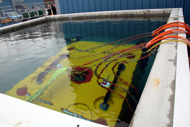 Ocean Networks Canada’s spare node on the bottom of the test tank. Credit: Ocean Networks Canada
Moran describes the U.S. cabled observatory off of the Oregon coast as “very complementary” to the Canadian effort. While these two projects are leading the way, other countries are planning similar deployments. “The Chinese now have funding to install three cabled observatories,” she says. “We have been meeting with the Brazilians; they are interested in a scientific VENUS-like cabled observatory north of São Paulo. In Europe, there’s a whole group that’s working together to try to install a wide range of observatories, including a cabled observatory, as far south as the Mediterranean, all the way north to the Arctic Ocean.”
NEPTUNE, VENUS, and OOI are primarily scientific projects, as well as drivers of technological developments—in both aspects analogous to space missions. However, they can also help predict natural ocean events that can have catastrophic consequences on land and help mitigate their consequences.
“We’re working toward an early warning system,” says Moran. “We already are hooked into systems that are already set up for that, both for earthquakes and for far-field tsunamis. But we’re working on more direct warning systems that could help the provincial side of the government here. Finally, we’re working with a new center that’s based out of Dalhousie University, called MEOPAR, for Marine Environmental Observation Prediction and Response Network, which was designed to develop transportable models, such as oil spill prediction models.”
“We’ve tracked all the major tsunamis in the last several years,” says Denman. “When you have a tsunami, say from Japan, there’s no way to detect its wave between Hawaii and Vancouver Island. Now we have this array out there. For the Japanese March 2011 tsunami, it gave us about an hour from the outer pressure gauge sensing to the innermost gauge, which is on the west coast of Vancouver Island.”
Emergency preparedness agencies also want to have warnings about storm surges and sea state. “Storm surge we can do probably from our pressure sensors in the middle of the strait,” Denman says. “We’re also looking now at possibly purchasing and installing some wave-rider buoys, so we’ll also be able to have more information on sea-state. We’d make these available as near to real time as we can and in a way that the emergency people can understand and digest quickly.”
 Alex Spicer, left, and Gyanju Xu man the logging station while ROPOS operations are underway. Video loggers create detailed written logs of all activity and identify organisms observed during a dive. The ROPOS (Remotely Operated Platform for Ocean Sciences) vehicle is a science/work-class ROV (Remotely Operated Vehicle) that is capable of operating to depths of up to 5000 metres. Credit: Ocean Networks Canada
MEOPAR is looking at “operational oceanography,” Denman says. “In other words, what kind of products can you put out there that are of value to people in the fishing industry or who are operating ferries. You know, in the winter BC Ferries has seven o’clock sailings on both sides of the main routes and in the dark they have to decide ‘Do we sail or don’t we sail?’ We can provide them with more information on sea state and some other variables.” ONC has a commercialization center, called Ocean Networks Canada Centre for Enterprise and Engagement (ONCCEE). “It works with primarily Canadian manufacturers to test sensors at our sites, with the plan that we will probably buy some in the future.”
The OOI wasn’t meant as a costal hazards or coastal warning system or an earthquake warning system, Cowles points out. “It wasn’t a design criteria of the OOI to connect with civil protection systems. It’s a research network with open access to the data.” However, he adds, “there will be real-time reporting of things that occur on sensors that are connected to the cabled network.”
Longitudinal studies—those that study change over long periods of time—require scientists and engineers to balance the need to maintain standards and procedures, so that data from different periods can be meaningfully compared, with the benefits of adopting new technologies that improve or expand data collection. OOI deals with this challenge by periodically reviewing whether advances in the marketplace justify replacing instruments with new versions or adding new instruments. Says Cowles, “As new sensors become available, our network and the infrastructure supporting the sensors is flexible enough to allow the addition of new types of measuring devices.”
Technological development will also affect cabled ocean networks in other ways. “We are incorporating fuel-cell technology into some of the upper-ocean buoys,” says Cowles, “and we are working with the vendor to provide underwater docking systems for some of the autonomous vehicles that will be deployed within the coastal array off of New England.”
In all fields of science, research requirements drive technological advances which, in turn, enable new scientific research. As seafloor sensor networks continue to grow in geographic coverage and sophistication, they will vastly increase our knowledge of the oceans and how we are changing them.