
A unique pairing of ESA’s Sentinel-1 satellites is providing scientists with one of the most detailed views ever assembled of Antarctic ice movement, allowing researchers to compare nearly three decades of glacier flow and ice-sheet dynamics. The new observations improve understanding of how Antarctica is responding to a changing climate and how ice loss may contribute to future sea-level rise.
Flying in close succession, the Sentinel-1 satellites collect radar observations that can detect subtle changes in glacier velocity and ice deformation regardless of cloud cover or seasonal darkness. Combining these measurements with historical satellite archives enables researchers to map long-term changes across one of Earth’s most remote environments.
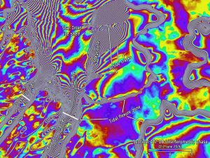
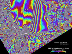
Acquired June 1 and 2, 2026, the Sentinel-1C–Sentinel-1D interferogram on the top image reveals major fractures and rifts in the ice shelf that were not present in the corresponding ERS-1–ERS-2 interferogram on the bottom image, which was acquired on Nov. 16 and 17, 1995.
Comparison of the two interferograms reveals a landward retreat of the tidal flexure zones (white lines) at Flask and Leppard Glaciers, significant changes in the shear zones between 1995 and 2026, and the development of active fractures in 2026 that were absent in 1995.
Image Credit: Contains modified Copernicus Sentinel data (2026), processed by ESA
