 Scientists are closely monitoring the return of El Niño conditions as warming sea-surface temperatures in the tropical Pacific begin influencing weather patterns around the world. New satellite observations provide an increasingly detailed view of changes occurring across the Pacific Ocean, offering researchers valuable information for seasonal forecasting.
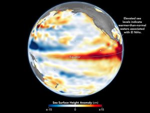
Earth-observation satellites measure sea-surface temperatures, cloud development, rainfall and atmospheric circulation, allowing scientists to track how El Niño evolves throughtime. The phenomenon can affect precipitation, drought, tropical cyclone activity and agricultural productivity across multiple continents.
In the accompanying image, higher-than-normal sea surfaces (red) are visible in the central and eastern Pacific on June 8, 2026, a few days before El Niño was officially declared. Data for the map were acquired by the Sentinel-6 Michael Freilich satellite and processed by scientists at NASA’s Jet Propulsion Laboratory.
Image Credit: NASA Earth Observatory/Lauren Dauphin
