Sensors and Systems
Breaking News
CGIS Qatar Case Study: Leveraging Vexcel Imaging for a True 3D City Model of Doha
Rating12345Graz, Austria • May 13, 2025 — The Centre for Geographic Information...
BlackSky signs multiple early access agreements with international defense sector customers for Gen-3 services
Rating12345Customers to integrate very high-resolution, 35-centimeter imagery into daily...
Automate 2025: Orbbec Launches Gemini 435Le, Empowering Robots to See Farther and Navigate Smarter
Rating12345DETROIT — At the largest robotics and automation show in...
  • Rating12345

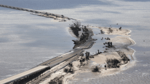
Damage caused by storm surge along the Sanibel Causeway in Florida during Hurricane Ian in September of 2022. (Image credit: Getty images)

NOAA upgraded its Probabilistic Storm Surge (P-Surge) model—the primary model for predicting storm surge associated with high-impact weather like hurricanes and tropical storms—to version 3.0. This upgrade advances storm-surge modeling and forecasting for the contiguous United States (CONUS), Puerto Rico and the U.S. Virgin Islands, and comes just in time for the 2023 hurricane season beginning on June 1 and running through November 30. 

The upgrade includes a number of new capabilities that will help forecasters better understand the risk of storm surge, such as: 

  • New forecasts for surge, tide and waves for Puerto Rico and the U.S. Virgin Islands.
  • The ability to run the model simultaneously for two storms. This capability can help during two landfalling storms impacting the CONUS, or one storm impacting the CONUS and one impacting Puerto Rico and/or the U.S. Virgin Islands.
  • Improved model calculations of friction over different types of land surfaces, which helps more accurately compute the extent of water inundation along the coast.