 Across the world’s oceans, including U.S. territorial waters, some vessels deliberately “go dark,” switching off AIS (cooperative beacon) to operate undetected. These actions can mask illegal fishing, pollution or non-compliant operations, posing risks to maritime safety, fair competition and environmental security.
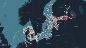
With its constellation of 17 satellites, Unseenlabs detects radiofrequency (RF) emissions from ships’ onboard electronics, enabling the identification and tracking of vessels even when AIS signals are turned off.
In November 2025, two additional satellites will launch with SpaceX, extending monitoring coverage across the Atlantic and Pacific Oceans as well as strengthening U.S. and international efforts to improve maritime transparency and protect ocean resources.
The accompanying image illustrates vessel activity near subsea infrastructure in the Baltic Sea, a critical area where RF-based monitoring helps ensure both operational safety and environmental protection.
Image Credit: Unseenlabs
