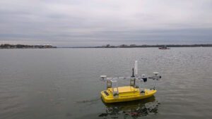
An uncrewed NOAA surface vessel on the Potomac surveying the river bed for debris. (Credit: John Gray/NOAA)
In the wake of the aircraft collision over the Potomac River near Ronald Reagan Washington National Airport (DCA), NOAA’s National Ocean Service activated response teams to support response and recovery efforts. Tragically, the incident claimed all 67 lives aboard the two aircraft and created significant recovery and salvage obstacles due to the frigid waters and complex wreckage field.
NOAA worked alongside the U.S. Coast Guard, National Transportation Safety Board, U.S. Army Corps of Engineers, D.C. Fire and Emergency Medical Services, and other local and federal partners to locate wreckage, support search and recovery efforts, and ensure safe navigation on the Potomac. Experts from across NOAA provided valuable data and mapping to guide divers, aid salvage crews, and keep response teams informed in challenging conditions.
