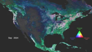
Anthocyanins, carotenoids and chlorophyll data light up North America, highlighting vegetation and its health. For the full visualization, visit https://svs.gsfc.nasa.gov/5548/. (Credit: NASA’s Scientific Visualization Studio)
A lot can change in a year for Earth’s forests and vegetation, as springtime and rainy seasons can bring new growth, while cooling temperatures and dry weather can bring a dieback of those green colors. And now, a novel type of NASA visualization illustrates those changes in a full complement of colors as seen from space.
NASA’s Plankton, Aerosol, Cloud, ocean Ecosystem (PACE) satellite is designed to view Earth’s microscopic ocean plants in a new lens, but researchers have proved its hyperspectral use over land as well.
Previous missions measured broad changes in chlorophyll, the pigment that gives plants their green color and also allows them to perform photosynthesis. Now, for the first time, PACE measurements have allowed NASA scientists and visualizers to show a complete year of global vegetation data using three pigments: chlorophyll, anthocyanins and carotenoids. Such multicolor imagery tells a clearer story about the health of land vegetation by detecting the smallest of variations in leaf colors.
