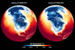
 In the wake of a winter storm that blanketed numerous U.S. states with snow and ice, unusually low temperatures gripped a large swath of the nation east of the Rockies in late January 2026. The cold spell was notable for severity, longevity and geographic scope.
This image compares surface air temperatures across part of the Northern Hemisphere, including North America, on Jan. 21 and Jan. 27. It combines satellite observations with temperatures calculated by a version of the Goddard Earth Observing System (GEOS) global model, which uses mathematical equations to simulate physical processes in the atmosphere. Dark blue areas indicate the lowest surface air temperatures.
Image Credit: NASA Earth Observatory images by Lauren Dauphin, using GEOS data from the Global Modeling and Assimilation Office at NASA GSFC
