
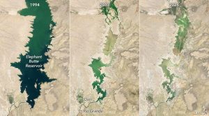
 Three satellite images show the dramatic decline of Elephant Butte Reservoir in New Mexico as prolonged drought and reduced flows in the Rio Grande have depleted the state’s largest reservoir.
The reservoir was nearly full on June 2, 1994 (left), in contrast with very low levels during periods of drought on July 8, 2013 (center), and July 27, 2026 (right). The images were acquired with the Thematic Mapper (TM) on Landsat 5 and the Operational Land Imager (OLI) on Landsat 8 and Landsat 9.
Elephant Butte stores water from the Rio Grande for agricultural irrigation and other uses in southern New Mexico and western Texas.
Image Credit: NASA Earth Observatory/Michala Garrison
