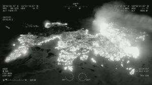
 In support of CAL FIRE’s firefighting efforts in Northern California, the California Air National Guard’s 163d Attack Wing operating out of March Air Reserve Base is using MQ-9 Unmanned Aircraft Systems (UASs) with full-motion video (optical and infrared) and ground imaging Synthetic Aperture Radar (SAR) capability, which can see through clouds and smoke.
“The 163d Attack Wing supports citizens during the fires by operating two missions under approval from the Secretary of Defense and the Federal Aviation Administration,” said Brigadier General Dana A. Hessheimer. “The two missions are to help fire crews assess fire perimeters and identify structures that have been lost. Through the efforts of our response team, 77,000 acres have been mapped and more than 1,300 structures have been identified.”
The intelligence and reconnaissance sensor suite on the MQ-9 includes the Lynx multi-mode radar and Electro-optical/Infra-red (EO/IR) high-definition camera. This type of support is critical to providing firefighters on the ground with situational awareness that assists with the strategic planning and resource placement essential to containing the fire in Northern California.
General Atomics Aeronautical Systems Inc., manufacturer of the MQ-9, also is working with the San Diego Fire Rescue Department and CAL FIRE to facilitate integration of real-time data into fire-fighting operations.
Photo Credit: General Atomics Aeronautical Systems Inc.
