Tuesday, April 24th, 2018
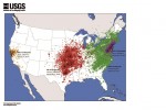
Why was an earthquake in Virginia felt at more than twice the distance than a similar-sized earthquake in California? Earthquakes east of the Rocky Mountains can cause noticeable ground shaking at much farther distances than comparably sized earthquakes in the West. A magnitude 5.8 earthquake in 2011 in Mineral, Va., was felt up to 600

Tuesday, October 24th, 2017
The International Association of Fire Chiefs (IAFC), Intermedix and Esri agreed to build the National Mutual Aid System (NMAS), the next-generation version of IAFC’s Mutual Aid Net tool built in 2008. The NMAS will use Esri’s ArcGIS platform and Intermedix’s WebEOC software to manage and track emergency services resources during mutual aid responses. During large-scale
Thursday, March 6th, 2014
Climate change is a “threat multiplier” and a critical component of future defense strategy, according to the Pentagon’s Quadrennial Defense Review 2014 released yesterday.
Sunday, August 26th, 2012
A new rapid damage assessment (RDA) system developed to aid disaster recovery has stormed through its first major test with flying colours. The Western Australian (WA) Fire and Emergency Services Authority (FESA) prototype enables Urban Search and Rescue (USAR) teams to instantly map property and infrastructure damage using mobile devices.
Tuesday, March 27th, 2012
The Open Geospatial Consortium (OGC) announced that the U.A.E. Ministry of the Interior, represented by Abu Dhabi Police GIS Center for Security, has become a Principal Member of the OGC to chair a new, planned international OGC Law Enforcement and Public Safety Working Group. In addition to advancing technical standards and best practices as voting
Saturday, November 19th, 2011
Leaders from Japan and the Association of Southeast Asian Nations met Friday to boost cooperation over maritime security and safety at a time when China is becoming increasingly assertive at sea. Prime Minister Yoshihiko Noda and the leaders of the 10 ASEAN members are expected to issue a joint declaration after their summit mapping out strategies
Tuesday, October 4th, 2011
Addressing delegates at Metering and Billing CRM Europe in the Netherlands next week, Frank Hyldmar, Executive Vice President, Elster Electricity International, will explore the crucial challenge of security in the Smart Grid. Ahead of the conference, Hyldmar, who is chairing the ‘Ensuring security and privacy’ session stated: “We encourage all utilities and industry players to put security at
Wednesday, July 27th, 2011
To strengthen the fight against climate change and be better protected against terrorist attacks or natural disasters, two calls for proposals were published on 20 July 2011 in the area of space and security research. The main aim of the space call is to support Europe’s ability to gather and utilise data gathered by satellites for the
Tuesday, May 24th, 2011
Interactive Government Holdings, a Service Disabled Veteran Owned Small Business (SDVOSB) specializing in providing National Security support to the U.S. government, and OpenGeo, a global leader in open source geospatial solutions, announced a reseller deal today that will enable Interactive Government Holdings to sell the OpenGeo Suite Enterprise Edition as part of its product offerings.