 Cartography and geomatics are rapidly changing. These changes are impacting the needs for a highly trained and capable workforce. Education is attempting to adapt and to provide a solution to these demanding and changing circumstances. Education professionals in the Czech Republic have developed a unique geomatics curriculum on themes related to “the relation of cartography and geomatics” and “the content of cartographic courses and its update”.
This paper describes the actual cartographic courses in geomatics curriculum of the University of West Bohemia in Pilsen (UWB) in the Czech Republic – their state-of-the-art, proposed changes and future plans. The proposed changes are based on changes in cartography and geomatics, too, experience in geomatics education and feedbacks from students and graduates. The purpose of this paper is not only to introduce our cartographic courses and geomatics curriculum, but also to arouse a discussion and to offer, share and gain inspiration, experience and knowledges. Last but not least there is an attempt to the emphasis of the importance of cartography in geoinformation sciences.
Why does the geomatics curriculum of UWB and its cartographic courses serve as an example of the relation of cartography and geomatics and an example of significance of cartography? Studies of geomatics in the Czech Republic have been founded in 1995 at the Faculty of Applied Sciences of the University of West Bohemia in Pilsen. But a teaching of geo-related sciences at the University of West Bohemia in Pilsen has longer history. Czech cartographer Jiri Pysek had founded studies of mathematical cartography at the Faculty of Education in 1991.
Geomatics have continued mathematical cartography, therefore cartographic courses have played an important role in geomatics curriculum always. Presently there are three main specializations at the study programme Geomatics: surveying and cadastre of real estates, geographic information systems and cartography. Just cartography represents the one of connecting links of all three specializations – the need of visualisation of spatial data via cartographic methods. (Baranova et al., 2007), (Geomatika, 2007-10)
Cartographic courses in geomatics curriculum of UWB
International organization for normalization (ISO) defines geomatics as “scientific and technical interdisciplinary branch focused on collecting, distributing, storing, analyzing, processing and presenting of geographical data or geographical information” (Sima, 2007). Geomatics represents the characteristic interdisciplinary scientific branch. Geomatics deals with collecting, distribution, storing, analyses, processing, interpretation and visualisation of spatial data and geographical information.
Those data comes from many different sources and are collected by various ways of surveying, cosmical surveying, mapping, cartography, remote sensing and photogrammetry. For their processing, administration and analysing information technology GIS is used. From the view of cartography it is important that the final representation and distribution of collected and processed spatial data is managed by cartographic methods and tools. (Cerba et al., 2009)
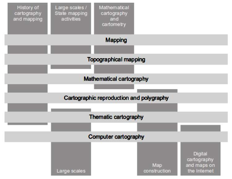
UWB geomatics curriculum offers two types of cartographic courses – the courses directly focused on cartography, geovisualization and mapping (e.g. thematic cartography, computer cartography, mathematical cartography, mapping, topography mapping etc.) and the courses applying the cartographic, mapping and geovisualization pieces of knowledge for a construction of outputs of analyses and/or collected data sets (e.g. introduction of geographic information systems and other GIS courses, application of computer technology in surveying, cadastre of real estates etc.). There are also some other courses (e.g. computer graphics, geodesy, photogrammetry, remote sensing etc.) marginally using some methods or approaches of cartography. (Baranova et al., 2007), (Geomatika, 2007-10), (Cerba et al., 2009)
The following list shows the actual content of cartographic part of geomatics curriculum in the UWB.
Cartography in the scope of geomatics curriculum of the University of West Bohemia in Pilsen is still focusing on increase of practical activities, upgrading of supporting materials, link between other courses and including solutions to joint projects. Students can apply and verify their cartographic skills not only during exams, but also by the cooperation on various projects (e.g. maps for handicapped, mapping of the temporal development of hiking routes, geovisualisation of Jewish cemeteries, algorithm development of isolines from triangulated irregular network etc.).
Changes and future plans
During the creation and updating of geomatics curriculum and cartographic courses in geomatics study programme in UWB we continually ask ourselves.
1.Are changes in content of cartographic courses necessary?
2.Is it meaningful to teach standard cartography for geomatics experts? Or should we focused only on some selected parts of cartography?
Continuous changes of the content of geomatics courses including cartography courses are necessary without question. Because these courses must reflect current tendencies in geomatics, mapping, geovisualisation and education and requirements of job markets. Our improvements and changes are inspired by topics described in Research Agenda of International Cartographic Association (Virrantaus & Fairbairn, 2007).
The third information revolution is the second reason for changes of geomatics curriculum and cartographic courses. The third information revolution represents the main general change in last years and decades. Cartography is significantly influenced by development of information technologies (IT) including web solutions. It could have seem that cartography will loose its significance and it will be only some kind of service for visualization of spatial data.
But IT have brought many new cartographic and cartography-related products, which are very popular and must be still developed, improved and integrated with education. Except paper maps the current cartography works with products like electronic maps and atlases, web and/or mobile applications, 3D models of landscape or buildings, scene animations, virtual reality models and geoimages of multimedia character, products of context cartography or temporal mapping.
Do geomatics experts need cartographic education? We think so, because all possibilities of practical applications of geomatics experts necessitate the knowledge of cartography and its methods of visualization of spatial data. All results of geomatics activities (e.g. GIS analyses, remote sensing, sensor measuring, field survey etc.) are mostly accessible in the form of maps or related products (e.g. plans, 3D model, globes, etc.).
Maps and other related products represents models of real world. They make possible to eliminate margin components of real world, to emphasise important objects or to interconnect phenomenons and events without real relationships. Therefore such products represent very attractive and intelligible conversion of complicated spatial data to graphic view.
The following list contain some concrete changes of cartographic courses of geomatics curriculum of UWB, which will be realized in the near future.
Conclusion
Any present-day GIT expert and geomatics engineers does not get along without maps and other cartographic products. Because cartographic outputs form the basis of the majority of geoinformation processes and these products are most often evaluated and of course shopped by public.
Therefore common cartographic education is still very important in the term of geomatics curriculum. It should not be replaced by some “simplified or limited cartography” focused on selected cartographic methods and rules applied in current software products. The document “Cartographia Catholica” (Cada & Cerba, 2009) describes some common points to improve cartography and cartographic education:
The knowledge of cartographic rules and books should not be the result of cartographic education. Cartographic education should lead to the ability to design and construct a map or map-related products. Such product must keep all cartographic rules but above all it must satisfy all user requirements. The education in the field of cartography is very important in the light of overall improvement of cartographic culture and standards.
References
1.BARANOVA, M., CADA, V., CERBA, O., JEDLICKA, K., JEZEK, J., SIMA, J.. 2008. Studies of Geomatics at the University of West Bohemia. In Proceedings 1. Sofia: International Cartographic Association, 2008. s. 133-137. ISBN 978-954-724-036-0.
2.CADA, V., CERBA, O. 2009. Cartografia Catholica. In 18. kartografická konference, Olomouc, 2009.
3.CERBA, O., JEDLICKA, K., JEZEK, J. 2009. Geospatial Data Visualisation in Geomatics Curriculum. In 24. International Cartographic Conference, Santiago, Chile. International Cartographic Association, 2009.
4.Geomatika na ZCU v Plzni [online]. 2007-10 [cit. 2010-01-18]. Resource http://gis.zcu.cz/en.
5.SIMA, J. 2007. Geomatics And Geoinformatics In Modern Information Society – Projection Of New Trends Into Their Curricula At The University Of West Bohemia In Pilsen [online]. In Scientia Est Potentia – Knowledge Is Power, FIG Commission 2 Symposium, Prague (Czech Republic), 7-9 June 2007. Resource http://gama.fsv.cvut.cz/data/geoinformatics/2007/06/07-09/papers/Jiri_Sima__Geomatics_and_geoinformatics_in_modern_information_society.doc.
6.VIRRANTAUS, K., FAIRBAIRN, D. 2007. ICA Research Agenda on Cartography and GI Science. XXIII International Cartographic Conference, 4.-10. August 2007, Moscow (Russia). International Cartographic Association, 2007.
7.ZENTAI, L. 2009. Change of the Meaning of the Term ‘Cartographer’ in the Last Decades. In 24th International Cartographic Conference. The World’s Geo-Spatial Solutions, Santiago (Chile), 2009. ISBN 978-1-907075-02-5.
