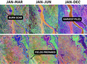
Examples of quarterly, semi-annual and annual satellite-based embeddings from Al Jazirah, Sudan, in 2024, allow users to identify critical food security signals such as burn scars, field preparation and harvest activity, using natural language. (Credit: Arizona State University. Embeddings generated with OlmoEarth.)
A new suite of geospatial innovations designed to turn data into actionable intelligence for global food systems was announced on May 27, 2026. The Geospatial Innovation for Food Security (GIFS) Challenge selected three project awardees to develop tools that will aid humanitarian agencies, governments and agricultural specialists to navigate the complexities of agricultural production, climate variability and supply chain disruptions.
Launched by Taylor Geospatial, a nonprofit organization focused on advancing geospatial artificial intelligence (GeoAI) for global public benefit, the GIFS Challenge addresses a critical gap in technologies to address food insecurity. While geospatial research is abundant, it often does not align with the problems those on the front lines actually face and stops short of providing usable tools.
For more information, visit the GIFS page on the Taylor Geospatial website.
