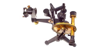
In June, 1909, Dr. Carl Pulfrich sent out a call for participants for a first “Vacation Course in Stereo Photogrammetry”. He, the founder of the stereo comparator (above photo) realized that after the introduction of this versatile instrument, some stimulus was needed to broaden the applications of terrestrial photogrammetry. The first course attracted 46 participants and took place in Jena, Germany, from October 4th to 9th, offering lectures and training for mapping applications. This first Photogrammetric Week began what is today the oldest symposium in geospatial technologies that attracts more than 400 participants from over fifty countries.
 1909: In March William Howard Taft succeeds Theodore Roosevelt as the 27th President of the United States – Theodore Roosevelt leaves New York for a post-presidency safari in Africa, a trip sponsored by the Smithonian Institution and the National Geographic Society. The construction of the RMS Titanic started at Harland and Wolff Shipyards in Belfast. Einar Dessau uses a short-wave radio transmitter and became the first radio broadcaster.
In May, the first Giro d’Italia is held in Milan, and is won by the Italian cyclist Luigi Ganna. In June, Alice Huyler Ramsey, 22 years old, was the first woman to across the United States by car, in total 3,800 miles, from ew York to San Francisco, California. The United States Army Signal Corp Division purchases the world’s first military airplane August) and an agreement between Germany, Italy and Switzerland gives the Germans and Italians access to the Gotthard Rail Tunnel October). Fritz Leonhardt (†1999), the famous structural engineer and father of the Stuttgart TV Tower, was born in December. Just a ew snippets, but looking back it seems, that 1909 was a year of looking forward.
What else happened in 1909? In June Dr. Carl Pulfrich sent out a call in the German Zeitschrift fuer Vermessungswesen (ZfV) to participate in a first “Vacation Course in Stereo Photogrammetry”. He, the founder of the stereo comparator (cover figure) realized that after the introduction of this versatile instrument for mapping (1901), some stimulus was needed to broaden the applications of terrestrial photogrammetry. The first course was organized by himself on a private basis and attracted 46 participants. It took place in Jena/Germany, from October 4th to 9th and offered lectures and Carl Zeiss’ instrument training for mapping applications.
The participation fee was 20 Marks. This first Photogrammetric Week started an amazing series of events, which is today the oldest symposium in geospatial technologies and attracts more than 400 participants from over fifty countries. We are grateful to Dr. Carl Pulfrich, his pioneering work to develop mapping instruments, and above all, to start a discourse between academics, vendors, and practitioners.
2009, 100 years later: Although we are facing a worldwide economic crisis and are optimistic to overcome it soon, the spirit of The Photogrammetric Week Series is more alive than ever. The 100th Anniversary – regularly numbered as the 52nd Photogrammetric Week1 (see appendix) – documents once more the visions, missions and applications of a geospatial science which is continuously developing high-quality hardware instrumentation, powerful software for workflow automation and new applications.
{swf}UK_300x250_CAD-GIS_hardcoded_vectormedia{/swf}
Photogrammetry as scientific discipline has undergone several paradigm shifts – its methods and systems have changed completely over the last 100 years. Once called the science to avoid computing, today we may state the science of High Definition imaging and geospatial computing. Since the 1950s, when the collinearity equations were analytically solved for the first time, the use of computers and electronic circuitry has revolutionized the way of data collection and data processing.
Fortunately, the spirit of The Photogrammetric Week Series did not change at all. It was, is and will be a Scientific Symposium and Further Education Course, which – owing to the lack of space – can treat selected topics at one symposium only. These topics are presented by international thought leaders and the OpenPhowo partners – companies offering hardware, software and workflows.
Therefore, a systematic and detailed review of every topic is often not possible. On the other hand, however, a one week course has a special attraction. It is the stimulating atmosphere of a collection of individual views in the mornings, the demonstrations in the afternoons, and the social events in the evenings, which makes every photogrammetric week very special.
Therefore, The photogrammetric Week Series is a story of success, since 100 years! for this reason, the Photogrammetric Week ’09, which is held traditionally in Stuttgart, from September 07 to 11, continues with a election of three topics. The Keynote and Invited Speakers give their reflections in the mornings and the OpenPhowo Partners are pleased to welcome the participants for interactive demonstrations in the afternoons. An attractive social program complements the scientific program to leave ample time for open discussions, intercultural relations and friendships.
Following the structure of previously published proceedings of this biennial Scientific Symposium and Further Education Course, the following three topics are discussed at the 100th Anniversary:
The introductory chapter contains a brief overview of the opening lecture dealing with Cloud Computing and the portfolio of the OpenPhowo partners. One of the buzzwords today is Cloud Computing. It is a new mode of use of distributed IT resources and will definitely be the next step in computing. Most probably, it will change the way how organizations use IT and think about IT. In a more rigorous thinking, cloud computing may relieve organizations from owning their own IT environments (“everything is offered through the cloud”).
The second chapter (first topic) is opened with a keynote about digital photogrammetric imaging in general. Since the ISPRS Amsterdam Congress (2000), when the first High Definition Airborne Camera System was shown to the public (by Leica Geosystems), new systems and vendors entered the digital airborne camera market.
Nowadays, those systems are well-established in mapping applications. Large-format systems, such as Leica Geosystems’ ADS, Intergraph’s DMC and Vexcel’s Imaging Ultracam have been purchased about 300 times, in total. In contrast to the high-end large format systems there is a parallel development going on. Digital Medium-format systems become more and more powerful – their resolution is increasing continuously. In the meantime, the vendors mentioned before have also a medium-format digital camera in their portfolio. It would be interesting to see performance tests over test sites which compare large-format and medium format cameras, according to their geometric and radiometric specifications.
If this positive trend of medium-format cameras will continue, those systems will replace the high-end systems in 3-5 years time. As The Photogrammetric Week Series attracts every time many photogrammetric professionals, those performance tests belong to the standard program. Here the DGPF test has to be mentioned. The German Society for Photogrammetry and Remote Sensing initiated this test 2008 and it will be finished 2010. Traditionally, the Photogrammetric Week is also a platform to present a brand-new digital airborne camera systems – this year the new Vision Map A3 system is introduced. This system has a remarkable imaging architecture.
Besides classical High Definition pan and true colour imaging a new thermal camera system is introduced. The demand for thermal imaging increases with the availability of countrywide coverage of 3D city models. Using thermal images as an extra texture layer of a 3D city model, an overall estimation of energy loss becomes feasible, for every building. Occlusions are overcome using oblique geometry and through the use of mobile vans as camera platform. 3D city models are demanded. Especially car navigation providers
would like to offer next generation systems able to visualize 3D buildings and routes on their screens. Therefore, about 100 European cities are reconstructed in 3D towards the end of 2009. It is interesting to hear about the experiences of this huge project, carried out by Blom ASA, Oslo. Finally, the first topic is concluded with a question mark. As High Resolution satellite imaging makes more and more progress, what means having many satellites with imaging capabilities in space orbits, do we still need aerial photography at all?
The third chapter (second topic) starts with a keynote about advanced data processing of airborne, static and mobile LiDAR point clouds. As the sampling of airborne LiDAR becomes more and more dense (about 20-50 points per sqm), the more the digital surface model is used for automated building reconstruction. In static and mobile applications dense 3D point clouds serve for automated plane feature extraction such as walls, doors, windows, etc. Those building structures can be used to validate a grammar capable to fill structure less regions in the data set. The fusion of 3D point clouds and High definition photographs leads to sophisticated products used for 3D virtual reality applications. Static LiDAR, in the market since the 1990s, becomes more and more attractive in engineering surveying, civil engineering and architecture – cultural heritage preservation benefits from this technology as well.
Automation is always challenge: Local 3D point cloud fusion for global georeferencing on the one hand, image and point cloud feature matching to fuse imagery and 3D geometry on the other hand. Mobile LiDAR complements the equipment so far used in airborne and static mode. It will be interesting to see, how mobile LiDAR will be used to complement and to up-date 3D city models as one main application, others will be driven by economic parameters. Using the StreetMapper system as one mobile mapping example, several applications in urban and rural mapping are shown.
Those systems rely completely on a powerful GPS/INS integration, supplemented by other sensors just to live support for the orientation parameters in case of failing GPS signals. Online geo-coding still was, is and will be in future a challenge. This business started with experiments using kinematic DGPS in the 1980s, also first Inertial Navigation Systems were examined for aerial applications. In the meantime, integrated GPS/INS systems solve easily the problem of sensor location and orientation, with high accuracy and reliability. Two vendors deliver competing IMUs: Applanix and IGI – both are referred to in mobile mapping applications.
Advances in Micro-Electro-Mechanical Systems (MEMS) have shown premising performance for chip-based inertial sensors. Thus, it will be interesting to watch those developments in the next 3 to 5 years. An application is demonstrated to use various terrestrial and aerial sensors to facilitate data collection for transportation objects.
The different types of data need to merge because there are so many sources of data throughout a roadway life cycle, and there is a need for a common three-dimensional model. Finally, this chapter is concluded by an overview to generate countrywide DTMs using RADAR data. Here, the NEXTMap Europe© solution of Intermap is introduced, a DTM having a 1 meter vertical RMSE for a grid spacing of 5 meter. The resulting data sets spans 15 countries and 2.2 Million km2.
The fourth chapter (third topic) deals with value-added photogrammetry. A keynote reviews advances in computer vision and remote sensing and concludes with lessons learned. Augmentation of 3D Virtual City models is a logical follow-up, once the static building ensemble has been reconstructed. Most probably, the computer game industry will show the way how virtual 3D city models are used to generate added value.
There is huge potential on the horizon: Simulations of all kinds may be carried out and fascinate with their results, for professional applications and gaming purposes as well. The work towards a fully interpreted virtual city has just began! standardization for such detailed models becomes an issue. Therefore, CityGML, the new international standard of the Open Geospatial Consortium, is presented and reviewed in detail. This data exchange format seems to be a first standard on the road to virtual city perfection.
New developments from pixels to Web are introduced by ERDAS. The spatial models along with the input data products are subsequently catalogued in an enterprise data management system and are published as interoperable OGC Web Services such as WMS (for maps), WCS (for images and terrain) WFS (for features) and WPS (for spatial models). Using High definition airborne photographs for image matching algorithms has shown, that due to the large overlaps dense 3D point clouds can be generated.
The most fascinating issue is the 3D point accuracy, which comes close to the airborne LiDAR RMSE. Herewith, the come-back of image matching is obvious. In future, further tests will validate these observations and will hopefully come out with the message, that using those camera systems for revisiting urban areas regularly will make airborne LiDAR obsolete (at least for some applications, such as 3D building reconstruction and true orthophotos).
The preservation of cultural heritage sites has become an issue for many years. We all know, that the achievements of the world’s societies are at risk. Consequently, cultural heritage sites, which are testimonies of individual uniqueness and the roots of an individual society are in great danger. Some of them will disappear, others have already disappeared for ever. CyArk, a foundation in California, meets this problem. The CyArk 500 project will attempt to digitally preserve 500 of the most important sites within the next five years using static LiDAR, surveying and photogrammetry. EuroSDR, an European organization serving to the needs of the National Mapping and Cartographic Agencies (NMCAs) has the overall objective, to contribute added value to national and therefore local data sets.
Within the INSPIRE initiative the EuroSDR members will coordinate their work and will contribute to an open-border Europe, at least geospatially. What about Google’s road map for the future? This year’s Photogrammetric Week has invited Google to speak about Google Earth, Google Map, Google Map Maker and Google StreetView. What an exciting company helping photogrammetrists and geospatial professionals to get the public awareness we missed before Google Earth was launched (2005). The integration of virtual 3D city models into Google Earth has become an issue since 2005.
Today, municipalities are interested to use the Google Earth Visualization Interface to demonstrate their citizens’ home town in 3D and to visualize new projects in the existing 3D model – all from the user’s desktop. 3D Berlin is a good example for an efficient cooperation between two university departments (Institute for photogrammetry, Univ. Stuttgart and the Hasso-Plattner Institute, Potsdam University) and a small enterprise (virtualCITY Systems) to see technology transfer as a challenge. In total 474.000 buildings have been automatically reconstructed and fully textured, covering an area of about 890 km2. The invited speakers of the Photogrammetric Week series, who are the authors of the essays, are always carefully selected as international thought leaders from academia, industry and consulting. With this book we continue our overall objective to represent the state-of-the-art of photogrammetric research, development, and technology transfer. The reader can take profit from the profound knowledge of the authors.
Since many years, photogrammetry goes along with the rapid developments in ICT, electronics and geoinformatics. It still is and will be in the future a fascinating geospatial science attracting all kinds of people: students, professionals and novices. The 52nd Photogrammetric Week continues the tradition to be a forum stimulating new developments, co-operations, and standardizations. Hopefully, also this book will contribute to bridge the gaps of several geospatial disciplines. The aforementioned main topics structure the book into four chapters. For this reason, the reader has fast access to the corresponding contributions. Not all papers match exactly the corresponding chapter headline, but may give an overview of neighbouring fields of interest as well.
This book could not be made possible without the help and discipline of the Keynote and Invited Speakers of the 52nd Photogrammetric Week. The editor gratefully acknowledges their cooperation to finish the papers in due time. Since the introduction of pre-printed Phowo proceedings 1993, the Institute for Photogrammetry (ifp), Universitaet Stuttgart, carried out the final word processing for the homogeneous book layout. Sincere thanks goes to Markus Englich, who is always a very reliable associate and has done again an excellent job.
Finally, we have met the deadline of the publisher, what is most important. Let me also thank Martina Kroma and Werner Schneider for their support in organisation matters. The book is also available in softcopy format (CD/DVD-ROM) for fast digital data access. Moreover, we offer the book content on the ifp Web Server for Open Access. Last but not least, we thank the publishing house Wichmann, Heidelberg, for publishing the book and cooperating with us since 1993.
———————————————————————————————————————
Written by Prof Dr Dieter Fritsch, Institut fuer Photogrammetrie, Universitaet Stuttgart
September 2009
100th Anniversary “The Photogrammetric Week (Phowo 09)”, Univ Stuttgart, Sept 7-11, 2009
[1] In order to represent the statistics of “The Photogrammetric Week Series” properly it should be mentioned here, that after World War II Carl Zeiss, Jena tried to continue this series in photogrammetry for the Eastern Block countries, parallel to those jointly organized by Carl Zeiss, Oberkochen and University Departments in West Germany. Horst Schoeler and Erich Feldkeller organized two courses as the 21st Photogrammetric Week (April 14 to May 12, 1958) in Prague and the 22nd Photogrammetric Week (June 6 to July 1, 1961) in Budapest, mainly for Eastern European photo-grammetric professionals.
