 Driven by wind, waves are at their most powerful during storms, yet the greatest threat to coastlines often does not come from the storm itself, but from the long swells that carry wave energy far beyond the storm’s reach.
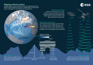
These long waves radiate across oceans, and their properties—such as wave period, or the time between crests—reveal the storm’s size and strength. For example, a 20-second period means a large wave arrives every 20 seconds.
To shed new light on storm waves and ocean swells a research team, funded through ESA’s Climate Change Initiative (CCI), combined data from the relatively new French–US SWOT satellite with the CCI Sea State project’s decades-long record that incorporates measurements stretching back to 1991. This record merges data from satellites such as SARAL, Jason-3, Copernicus Sentinel-3A and -3B, Copernicus Sentinel-6 Michael Freilich, CryoSat and CFOSAT.
Image Credit: ESA/Planetary Visions
