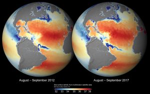
Global sea-surface salinity maps from ESA’s Climate Change Initiative show the difference for the same period in 2012 and in 2017. Note the differences in the spreading of the Amazon and Mississippi River plumes. (Credit: ESA Sea Surface Salinity CCI)
The salinity of the ocean surface can be monitored from space using satellites to give a global view of the variable patterns of sea-surface salinity across the oceans.
Unusual salinity levels may indicate the onset of extreme climate events, such as El Niño. Global maps of sea-surface salinity are particularly helpful for studying the water cycle, ocean/atmosphere exchanges and ocean circulation, which are all vital components of the climate system transporting heat, momentum, carbon and nutrients around the globe.
A new and ongoing project for ESA’s Climate Change Initiative (CCI)—a research program dedicated to generating accurate and long-term datasets for 21 Essential Climate Variables, required by the United Nations Framework Convention on Climate Change and the Intergovernmental Panel on Climate Change—has generated the most complete global dataset of sea-surface salinity from space to date.
“The project aims to make a significant improvement to the quality and length of the datasets available for monitoring sea-surface salinity across the globe,” said Susanne Mecklenburg, head of ESA’s Climate Office. “We are keen to see this new dataset used and tested in a variety of applications, particularly to improve our understanding of the fundamental role that oceans have in climate.”
The research team, led by Dr. Jacqueline Boutin of LOCEAN and Nicolas Reul of IFREMER, has merged data from three satellite missions to create a global timeseries that spans nine years, with maps produced every week and every month at a spatial resolution of 50 kilometers.
They used observations of brightness temperature to derive sea-surface salinity from microwave sensors onboard the SMOS, Aquarius, and Soil Moisture Active Passive satellite missions.
Boutin said, “By combining and comparing measurements between the different sensors, the team has been able to improve the precision of maps of sea-surface salinity by roughly 30%.”
Salinity measurements taken since the 1950s indicate that globally, the more saline areas of the ocean are becoming saltier, and the freshwater areas are becoming fresher. The data for this, however, are relatively coarse, taken by ships.
It is only since the beginning of the 21st century that ocean floats called Argo have been installed, on average every 300 kilometers, to provide subsurface salinity vertical profiles between approximately 5- and 2,000-meter depth at 10-day intervals.
“Monitoring salinity from space helps to resolve spatial and temporal scales that are poorly sampled by in situ platforms that make direct observations, and fills gaps in the observing system,” says Boutin.
The dataset is freely available for download from the CCI Open Data Portal.
