 Cicada Design Inc. recently won a 3D Award for Territory Management at the imagina conference in Monaco in the Urbanism and Landscape section. Their work for the Mount Pleasant Secondary Plan located near Toronto, Canada included restoration of a natural heritage system for the area including woodlands, wetlands, watercourses and valleys. This effort included a high level of advanced 3D city urban modeling and visualization.
Project background
Cicada Design was approached by the principal Planning Consultant – Malone Given Parsons to provide an accurate visualization through an animation and still images of the the Mount Pleasant Secondary Plan located near Toronto, Canada. In particular, the focus was on the restoration of an identified natural heritage system (NHS) that included publicly accessible valleylands and watercourse corridors, woodlands, wetlands, and environmental buffers being created through the plan’s policies.
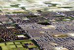
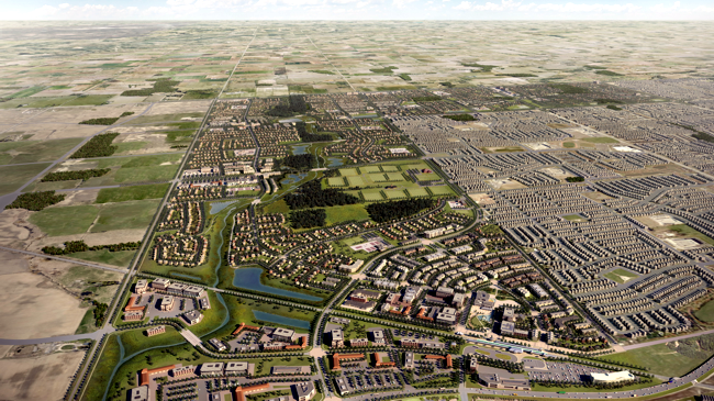 Mount Pleasant Secondary Plan – Aerial View North
These landscape areas collectively become the spine for the development of surrounding land areas. We were asked to provide an accurate visual summary of the proposal providing a sense of scale and realistic landscape as envisioned by the urban, ecological and landscape consultants. The resulting design visualization allowed, stakeholders, city council and the public a comprehensive and accessible insight into the approach to responsible and sustainable growth for the region.
“Approved by City Council on February 23rd, 2010, the Mount Pleasant Secondary Plan will guide the sustainable development of this Greenfield community that will soon be home to over 40,000 people. The Mount Pleasant Community is 875ha of land located within the North West Brampton Urban Development Area and features 147ha of restored Natural Heritage System Lands that will protect and enhance existing and restored natural features, woodlots, corridors, watercourses and wetlands, increasing natural cover from the existing 6% to 17%.
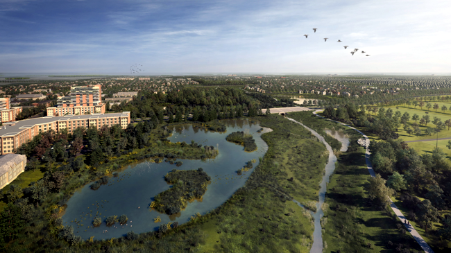 Mount Pleasant Secondary Plan – Aerial Wetland Original
This transit-oriented community is adjacent to the Mount Pleasant Village Mobility Hub centred around the GO Transit Station, providing both communities regional and local higher order transit service. Mixed use, higher density development is to be provided at transit nodes along a Transit Spine Road providing convenient pedestrian access to transit services and local amenities.
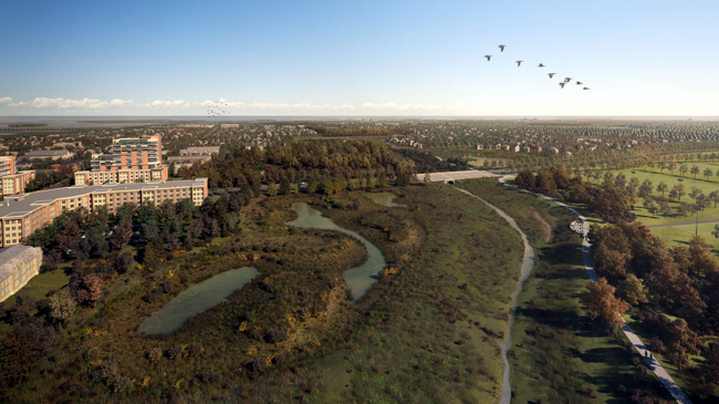 Mount Pleasant Secondary Plan – Aerial Wetland Low
The Plan also includes provisions for conservation of heritage resources; a hierarchy of parks and retail and commercial designations; strategically placed schools and places of worship; and gateways, networks of trails and pathways connecting the community with existing and future communities, all with a high level of urban design and compliance with the principles of the Provincial Growth Plan.
Innovative policies, implementation tools and processes have been established that includes commitments at the Federal, Provincial, and municipal level as well as landowners and approval agencies to provide for the early provision of the necessary infrastructure to bring this plan into a reality.”
Presentation approach
Over a 12 week period we summarized several years of planning in the form of an animated presentation. We focused on the key theme of a sustainable and long-term approach that the development of this community held for Brampton. A layered structure of vegetation and building typologies was developed to depict the planning systems being utilized to support this type of sustainable design.
The animation begins with the introduction of a new transit node that combines regional rail systems with a localized transit system. The layered approach to the landscape emanates from a waterway travelling from North to South. It becomes the principle subject of restoration to a series of natural habitats and more structured park elements that connect into the existing city system.
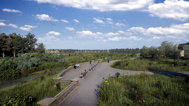 Mount Pleasant Secondary Plan – Lookout
The depiction of groundcover, trees and diurnal ponds was created in consultation with the ecologists that were part of the design team. The proposed node based community development designed around the watercourse landscape spine depicts a series of localized centres that afford convenient and walkable neighbourhoods.
We sequenced large scale aerial views and specific detail views to give a human scale reference to the organization of the scheme and its textural qualities. Motion Graphics are used in conjunction to depict the underlying planning ideas and regional transit organization.
The production of the video posed a significant challenge in handling the large amount of data common to schemes of this size. Developing a storyboard draft of the presentation was a key element in structuring the themes and accommodating consultant ideas throughout the process. As the 3d elements were developed the storyboard gave way to wireframe previews of the presentation and posted on a collaborative website (www.cozimo.com) to afford consultant comment and notes on an adhoc basis.
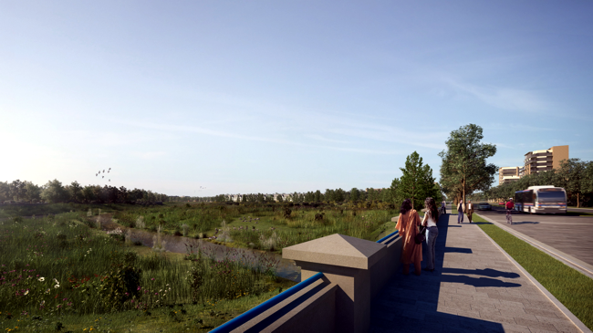 Mount Pleasant Secondary Plan – Bridge
The trees and groundcover elements are textured 3d models to provide a significant sense of scale and realism to the area. The building types, walkways and roads were 3d models developed from 2d planning cad data. The initial topography was derived from an accurate aerial Lidar scan of the area and then modified as needed for the watershed restoration scheme.
Aerial photos were used to create a more generalized context texture of the region. These 3d elements were broken into numerous files that were referenced into specific camera shots. Compositing each shot maintained some flexibility in changing landscape or building elements and controlling their colour and presence in the scene. Vehicular traffic was inserted with a rule based extension which minimized the amount of hand animation for background scenes. The entire production was rendered using global illumination techniques to further enhance the realism of the scheme.
———————————————————————————————-
Michael Starr, BArch – OAA – MRAIC is principal at Cicada Design Inc. 35 Golden Avenue, Suite 100, Toronto, Ontario, Canada – M6R 2J5
Project Web Links:
Mount Pleasant Secondary Plan and Block Plan
OPPI Excellence in Planning Awards 2010
Client:
Mount Pleasant Landowners Group
Lead Planning and Urban Design Consultant:
Malone Given Parsons Ltd.
Concept Visualization and Production:
Cicada Design Inc.
Production Team:
Dalibor Cizek, Ilya Floussov, Avaiz Hashmi, Jonah Humphrey, Jon Neilon, Dan Oteleanu, Spencer Rand, Steve Renard, Dmitry Soldinikov, Michael Starr
