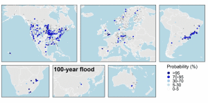
An image from the new report shows the updated probability of 100-year floods worldwide.
Severe river floods are escalating in temperate climates and putting at risk populations, livelihoods and property, according to evidence published in Geophysical Research Letters by an Oxford-led international team.
The first global examination of recent changes in the size, frequency and probability of extreme river floods using historical river records, the paper shows that dangers of extreme river flooding demand close monitoring of rivers for decades to come, to understand and account for the potential impact of such changes.
Dr Louise Slater, the main author and Oxford expert in flood risks, warns, “Our work shows the magnitude and frequency of floods are changing substantially in different climates of the globe. Flood maps need to be regularly updated to keep up with these changes and protect people and their livelihoods.”
Using historic recorded magnitudes of river flow, the team found that overall, floods have mostly decreased at the global scale. In arid, tropical, polar and cold climate zones, 20-year floods decreased between −33% and −12% on average since the 1970s. This was most visible in regions such as northeastern Brazil, eastern Europe, parts of western United States and parts of northern China.
The team suggests these decreases may be caused by a range of factors such as flood-control measures, climate changes and decreasing soil moisture, where drier antecedent conditions offset flood magnitudes (due to increasing temperatures, decreasing rainfall or groundwater depletion).
By contrast, the size of 20-year river floods increased by 22% on average since the 1970s in temperate climate zones such as Atlantic-facing Europe, southeastern Brazil, and southeastern China. According to the team, it is likely some of these increases result from climate change and variability, but no direct link was drawn within the research paper.
In temperate countries, it is not just the size of major river floods that is increasing. The paper shows that major floods have also been occurring more frequently, which is why it is essential to maintain up-to-date flood risk mapping.
