 As the chief seaport and capital city of Angola, Luanda is undergoing major reconstruction with the development of infrastructure projects that include new public housing, highways, and business and commercial space. The African nation was ravaged by 27 years of civil war before a cease fire was reached in 2002, and the Angolan government has since looked to the private sector to help rebuild the country’s center of commerce.
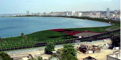
A critical first-step in that process is an ambitious $2 billion seafront rehabilitation project, which broke ground in November 2007 and is expected to be completed by 2014. The Luanda Bay Project is a massive plan to revitalize the seafront by removing layers of polluted sediment from the bay to open natural drainage channels. The dredged material will be used to reclaim land along the shoreline and create seven new parcels for parking lots, public leisure places, office buildings, and a shopping center.
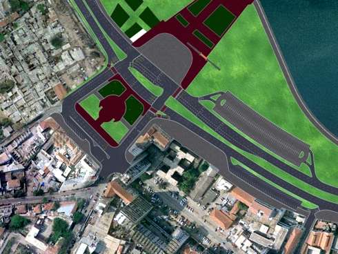
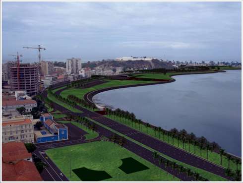 The project also includes an expanded highway system with several lanes to alleviate traffic congestion in the area. Initiated by the Luanda Waterfront Corporation, the Luanda Bay Project was a hard sell.
Government funds are being directed to the pressing priorities of providing basic housing, public services, education, and healthcare; rebuilding infrastructure; and supporting rural development initiatives in the aftermath of prolonged war.
To secure private funding for the project, which will be operated under a long-term land-occupation concession grant, the firm needed to demonstrate the enduring environmental, social, and economic benefits.
The project was designed at risk and then presented for approval using a realistic 3D visualization. Given the nontechnical background of the government officials, environmental groups, and private financers who would decide the fate of the project, 3D visualization was the most effective way to explain the architectural design concepts and sustainable engineering solutions.
The complex project addressed a range of issues ranging from cleaning up the polluted bay and minimizing environmental impacts during construction to building high-quality infrastructure for transportation, housing, and commerce.
The visualization was to be nothing less than a vision of Luanda’s renaissance. Vela VKE, the lead consulting engineer on the project, approached Graphic Engineering Solutions and Services (GESS) to help create animated videos with fly-throughs and drive-throughs that would give the audience a meaningful experience of what the completed development would look like.
“The undertaking presented several challenges,” said Brett Forbes, managing director at GESS. “Essentially, Vela was asking us to accurately depict its vision. This meant turning the 2D engineering data into a high-quality video that included all kinds of minute detail.
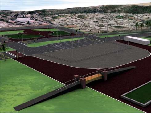
The firm wanted us to capture and literally model every piece of road furniture, including moving cars, street lights, bus bays, paving blocks, and even the little poles next to the walkways.
 What’s more, since the design was still in progress and changing on a daily basis, we had to make sure we captured those updates in our model.” Forbes also noted that because the Angolan government was concerned about the environmental impact of the project, it was critical that the animations incorporate detailed specifications of the construction methods. GESS used a total of seven software packages to accomplish the visualization, but it did the majority of the work using MicroStation, GEOPAK, and MXROAD.
Throughout the project, GESS had to coordinate with engineers, architects, and environmentalists to get all the material it needed. Most of the 2D designs the designers sent over were in MicroStation and GEOPAK, which gave GESS a head start on the project.
“Using MicroStation and GEOPAK Site, we were able to quickly and seamlessly export 3D smart lines representing all of the project features and import them into MXROAD, which has the ability to rapidly organize tens of thousands of design and survey triangles into the required material groupings for high-end visualization work,” Forbes explained.
In MicroStation, all of the 2D line work representing road markings, parking areas, traffic signals, sign gantry, and proposed tree locations were then easily draped into design meshes.
This was an essential part of the visualization process, as it took the 2D engineering design from paper plans to a realistic 3D model, which was much easier for everyone to understand. The project also called for some artistic license.
“We incorporated aerial photography and pictures of the existing waterfront, several of which we got by hiring a media company to take pictures of the area,” said Forbes. Working under tight deadlines, GESS kept pace by integrating GEOPAK Site modeling with MXROAD via LandXML, which ensured up-to-the-minute changes were incorporated seamlessly and the team could quickly produce multiple iterations.
 To make sure 3D renderings were hitting the mark, GESS attended regular review meetings with the designers and architects. These meetings also kept GESS up to date so it was able to quickly incorporate any forthcoming changes.
The finished videos displayed all aspects of the Luanda Bay project, successfully demonstrating how the project addresses the lack of space for housing, offices, and shops – much less hotels, tourism, and leisure – by rehabilitating the polluted bay and developing sustainable infrastructure along the waterfront.
The Angolan Cabinet Council approved the undertaking in September 2007. Planned for completion by late 2008, the $125 million public works phase of the seven-year project includes the environmental cleanup, public infrastructure development, and land reclamation.
By mitigating a quarter century of sewage runoff and solid-waste pollution in the bay, the first phase alone will have a positive impact on the lives of subsistence fishermen who depend on the bay for their livelihoods.
“This is a country that has gone through huge political upheaval, and this is not just about doing a waterfront revival – it’s a renaissance of an entire city,” said Forbes. “This multibillion dollar project would not have been approved without Bentley software and the high-end 3D visualization it enabled us to create.”
—————————————————————————————
Article by Graphic Engineering Solutions and Services, Pretoria, South Africa.
More information: www.gess.co.za
