In the last decades the interest for sustainable development of mountain areas has considerably increased for different reasons. As stated in chapter 13 of AGENDA 21, mountain regions are a source of biodiversity and environmental resources. At the same time, the population’s decrease generally caused a loss of indigenous knowledge and natural resources conservation, too.
Introduction
The main consequences are soil loss and environmental degradation. These processes deserve immediate action and they require an interdisciplinary approach to the integrated analysis of the ecosystem components (soil, topography, land cover….).
AGENDA 21 (Programme “a”) defines several main goals to achieve about “Generating and strengthening knowledge about the ecology and sustainable development of mountain ecosystems”. Among them there is the building or improvement of geographical and ecological knowledge and management. In this framework, Geographic Information Systems (GIS) play a fundamental role in the management of big amounts of territorial data.
In Italy, the Province of Turin has developed a Strategic Project about land maintenance, showing the lack of objective planning criteria supporting ordinary maintenance. The Province has defined several study areas which differ for morphology, hazard and risk factors.
The cooperation between Turin Province and the Faculty of Agriculture led to a guide-line for planning and acting territorial maintenance. The project has then evolved in a further experiment with the aim of deepening, through a multidisciplinary approach, the knowledge in soil stability monitoring through GIS modelling and physical indexes from soil survey.
This paper’s aim is to describe, in two parts, the main steps of the development of the GIS-based methodologies for hazard/risk assessment and land maintenance in two different study areas. In part one the method integrates the DEM and landscape ecology approach, while in the second one the analysis and assessment of different soil dynamics in relation with vegetation cover.
Valle Sacra Case Study: Potential Hazard
The first study area is located in Valle Sacra, in the North-Eastern part of Piedmont (45° 26′ 24″N; 7° 39′ 50″E). It covers the Piova watershed (2912 Ha). The altitude range is 370 m above mean sea level to 2406 m. Altitude increases northwards, showing the transition between highlands and steep mountain slopes.
Morphological modelling and ecosystem functionality are strongly affected by land degradation and land cover evolution processes.
The main trigger factors of hazard and risk in the area are: complex topography with steep slopes, soil erosion, landslides, slope failures due to extreme meteorological events, frequent fires affecting the evolution of vegetation covers, diffuse settlement.
Forest fires are typical of winter season, when fire behaviour is influenced by foehn, a katabatic wind blowing down the Alps, heating air as it comes under greater atmospheric pressure, creating strong gusty warm and dry winds.
River dynamics are influenced by hydraulic geometry as altered profiles, narrow cross sections and vegetation growth in riverbed can modify Manning’s coefficient, influencing energy loss in water flow. These phenomena commonly cause flash floods due to extreme storm events.
Moreover, the socio-economical marginality of the area has determined a general lack of territorial maintenance. Anyway, the valley is characterised by a high settlement density that requires adequate emergency management. This reason, together with high heterogeneity of hazard and risk factors, led to the choice of this study area.
Existing base maps, as required by the project partners, have been rasterised and classified to obtain derived maps for the following GIS-based analysis .All the classification processes have followed a 5 classes subdivision (Lorito et al., 2003), in order to define critical values, with a minimum of 1 and a maximum of 5.
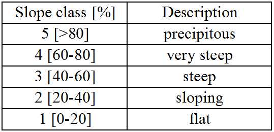
The 3D Analyst Extension (ESRI-ArcGIS) computed the DEM with 10 m cell size from the contour lines obtained from the regional vector map at 1:10000 scale. The slope map has then been derived from the DEM and classified using the Spatial Analyst Extension, following the threshold values proposed by Hippoliti (1994) for forest harvesting (Table 1).
Land cover and vegetation maps
Forest cover and other cover types maps have been merged in an unique layer; this product was then converted in raster format and reclassified considering forest health conditions, forest cover dynamics, land use and management. The classification criteria (Table 2) have been adopted.
Geological map
The geological map was scanned and digitized in shape file format, then converted into a raster, and reclassified, according to natural hazard records. The study by ARPA – Regional Environmental Protection Agency (1999), about landslide and rockfall events frequency on different geological substrates, has been followed as a guide-line. Therefore highest critical values have been assigned to ancient river sediments, medium to schist, minimum to granite formations.
Results
A parametric model has been adopted, summarizing the different factors’ critical values (topography, land cover, geology) through map algebra procedures. Then the result has been reclassified into five classes as in the base layers (Table 3).
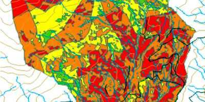
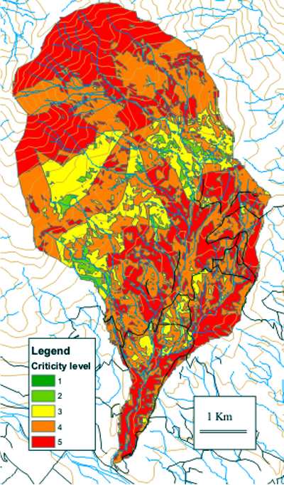
The final result is the map in Figure 1, representing a global hazard index. This kind of information was then integrated with field surveys, in order to verify the automatic individuation of potential processes and to identify actual degradation phenomena.
Discussion
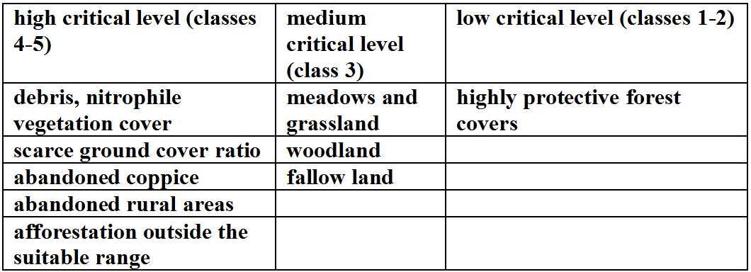
The main problems in Alpine valleys are related with lack of forest management and assessment; they are often influenced by lithological and morphological dynamics too. Class 5 is characterised by landslides and slope failures. There are also several slopes subject to jointed morphology, consequent water infiltration with physical degradation and loss of stability.
In class 4, with extension similar to the previous class, the main hazard are related with four types of vegetation cover:
a) Burnt areas, with high frequency of forest fires, covered by bracken fern, a fire-adapted species;
b) Scarcely burnt areas completely invaded by white birch;
c) Larch afforestation outside the suitable altitude range, in burnt areas, with consequent lack of mechanical stability;
d) Abandoned chestnut stands.
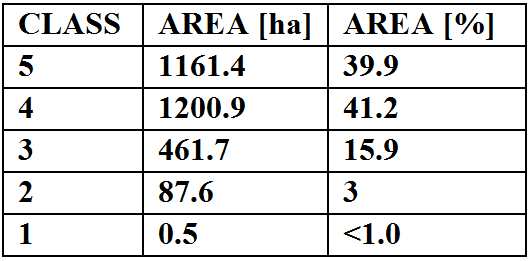
Due to land abandonment many minor hydraulic arrangements and slope conservation practices show failure and degradation; these conditions are typical of class 3.
In the last century the evolution in vegetation cover led to an improvement of slope stability; this phenomena are even more common in class 2, showing an advanced stage of evolution towards climax vegetation.
Class 1 covers a small fraction of the study area with limited slope values and moderate stability. Moreover the whole area is highly populated, even in the upper part of the basin characterised by the above natural hazard. This factor, increasing risk condition, is a key point in land management and in the attribution of critical values.
Integrating these elements, homogeneous environmental units has been individuated, characterised by similar trigger factors, actual processes and problems. They provide a basis for planning actions in time and space. Units also provide a global evaluation of land critical elements, connected with river dynamics, slope instabilities and erosion processes.
Integrating map algebra results with field surveys data led to the units definition, then to the classification of land maintenance units. Among these, four main categories have been identified (Figure 1).
Conditions and hydraulic characteristic of rivers
Rivers located in the upper part of the basin are often conditioned by debris-flow events, due to extreme precipitations. This may cause intense undercutting. In the lower section there are mainly deep and V-shaped rock riverbeds. The stream sediment dimension analysis showed high frequency of very coarse material, sometimes including boulders.
From the vegetational point of view, riverbanks are covered by trees with low mechanical stability on scarcely developed soils, characterized by poor organic matter content and periodical litter removal, reducing root penetration and soil aggregation which may cause tree overturning.
There are frequent lateral erosion phenomena in the whole study area. High stream velocity and steepness determine sediment transport and consequent deposition in obstructed cross sections (boulders, fallen trees …).
River crossing tipology and dimensioning
Cross sections survey showed frequent narrowing in hydraulic geometry, limiting flow and sediment transport. Obstructed sections may be a trigger factor for landslides and consequent increase in sediment transport.
The importance of periodical surveys has been underlined, in order to plan the removal of dead trees and sediment deposition due to floods and landslides, restoring the original section geometry.
Tracks and minor roads characteristics and management
Soil stability is conditioned by the management and maintenance of minor roads and forest tracks. The spatial distribution and spread of instability processes is often related with the presence of roads as they influence the surface runoff and modify slope morphology.
Road network can convey surface flow in preferential paths causing rill and gully erosion and also road obstruction; drainage pipes should drain the excess of water. Here periodical cleaning is required to ensure their regular efficiency.
Vegetation cover characteristics
The main vegetation covers involved in instability processes are: chestnut stands, burnt areas and pastures. They may act as trigger factors because they’ve lost the original protective function against erosion and soil loss.
Chestnut trees are often overmature and attacked by the chestnut blight; sometimes they are affected by forest fires, too. The traditional silvicultural methods were simple coppice and coppice with standards, with single-layer vertical structure. Such cover types have become ecologically and mechanically vulnerable due to structural characteristics, overmaturity and single-species composition.
Burnt areas show a drastic reduction in shrub cover, regeneration damage and soil aggregates alteration. The increased porosity in canopy cover can increase splash erosion, as the main effect of the canopy is assumed to be absorption of the energy of the falling raindrops.
In abandoned pastures, herbaceous cover grows vertically without any grazing disturbance. Hence graminaceous stems tend to lay down, increasing runoff and reducing water infiltration; in standard conditions grazing and lateral-spread regrowth would keep monocotyledon stems shorter, increasing soil protection.
On the other side, overgrazing can thin herbaceous cover; bare soil is more susceptible to sheet erosion and rilling. Maintenance actions should restore the protective function of these vegetation covers, enhancing soil conservation and slope stability.
Conclusions
The above elements are the criteria for land maintenance units individuation. Units define the kind of ordinary maintenance action and the corresponding timetable. Each unit is independent of its location, because it’s described by critical components and values, characterised by principal instability components and main trigger factors; similar phenomena cause the same event typology and they deserve homogeneous actions.
The actions are collected in a reference manual containing guide-lines to be applied all over the Province territory. These criteria allow decision makers to carry out land planning and hazard assessing following a standardised approach. In a second phase the project has focused on soil stability analysis, methods and details are presented in part 2.
—————————————————————————-
D. Godone¹; G. Garnero¹; R. Chiabrando¹; A. Caimi²; S. Stanchi²; E. Zanini²
¹Turin University – DEIAFA, Via Leonardo da Vinci 44, 10095 Grugliasco (TO) Italy – [email protected]
² Turin University – DIVAPRA, Via Leonardo da Vinci 44, 10095 Grugliasco (TO) Italy
