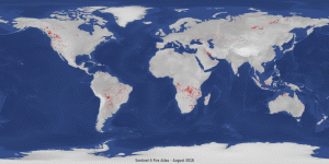
Global fires detected in August 2018 compared to August 2019. The Sentinel-3 World Fire Atlas recorded 79,000 wildfires in August 2019, compared to just over 16,000 fires during the same period in 2018.(Credit: Contains modified Copernicus Sentinel data (2019), processed by ESA on ONDA Copernicus DIAS)
Data from the Sentinel-3 World Fire Atlas shows that there were almost five times as many wildfires in August 2019 compared to August 2018, but a detailed analysis reveals precisely where these fires have been occurring, most of which were in Asia.
The Copernicus Sentinel-3 mission recorded 79,000 fires in August this year, compared to just over 16,000 fires detected during the same period last year. These figures were achieved by using data from the Sentinel-3 World Fire Atlas Prototype, which is also able to provide a breakdown of these fires per continent.
The data reveals 49% of fires were detected in Asia, around 28% were detected in South America, 16% in Africa, and the remaining were recorded in North America, Europe and Oceania.
Working like thermometers in the sky, the sensors on satellites measure thermal infrared radiation to take the temperature of Earth’s land surfaces. This information is used to detect and monitor the heat emitted by the fires.
Using its two dedicated fire channels, the Sentinel-3 World Fire Atlas uses a simplified operational version derived from Wooster et al. 2012 in order to identify all active fires at night.
Data gathered are used to plot the number of fires occurring monthly. The number of input images from Copernicus Sentinel-3A satellite were around the same from one year to the other.
Even if the atlas cannot pick up all fires due to satellite overpass constraints and cloud coverage, it is statistically representative from one month to the other and from one year to the other.
ESA’s Olivier Arino comments, “We have never seen an increase of wildfires of this kind since the ATSR World Fire Atlas was created in 1995.”
