Today, GIS is becoming more part of business processes, and the consequence of this change is that there are many more users with much higher requirements regarding the availability of GIS services. This column describes the path from a workgroup to an enterprise GIS.
Geographic Information Systems are changing all over the world. In the past GIS was often used by a small group of specialists whose job was to solve complex geospatial questions. Today, GIS is becoming more part of business processes, and the consequence of this change is that there are many more users with much higher requirements regarding the availability of GIS services. This column describes the path from a workgroup to an enterprise GIS.
There are some elementary differences between these two types of GIS. The first difference is that in an enterprise GIS, every decision has to be aligned to the strategy of the company. Moreover, it is not enough to have a small project area without precise business requirements, for the enterprise needs solutions that fit for the whole company and are connected to business processes.
The GIS department changes from a service consumer to a service provider. So you see, service oriented in the title of this article doesn’t just mean service-oriented architecture (SOA), it also means the internal structure of the GIS department. There are very often business critical processes that use GIS components, so the GIS resources will also have to change.
Implementation Overview
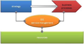
The first step to implement a service-oriented enterprise GIS is to identify how GIS can help the company achieve its goals. This can be done by analyzing the enterprise strategy and defining GIS-relevant components. The next step is to initialize a central GIS service management that translates the strategy into reality, and that also manages the GIS resources and brings them as a service into business processes. These resources may be hosted on in-house IT infrastructure or can be consumed from the cloud.
|
|
|
Figure 1: Interaction of enterprise components |
Strategic Alignment
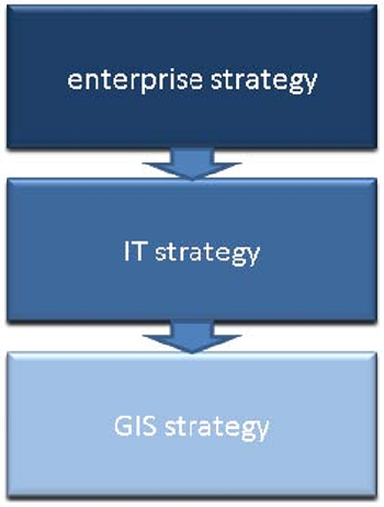
The first thing to realize to achieve a strategic alignment is that GIS is an IT technology. The IT department has aligned its activities to the enterprise strategy for many years, so there are already best practices on how to do this. One international standard containing those best practices for IT governance is called COBIT (COntrol OBjectives for Information and related Technology). It contains detailed models for transforming strategic goals into measurable components.
The implementation is made easier if GIS is part of the IT department, because it just has to align its strategy to the IT strategy, because of this one is already aligned to the enterprise strategy.
|
|
| Figure 2: Strategic alignment |
The next step is to build a balanced score card for the GIS department. It starts with defining a vision and mission. For example: “The vision of our GIS department is to support proactive other departments in their business processes with geographic information.” The balanced score card enables the GIS department to measure its performance and document the value it brings to the enterprise.
Process integration
It is very import to analyze the GIS processes on the way to an enterprise GIS. They have to be strictly separated into production and service processes. A production process for example is when the GIS department produces high end cartographic maps. This kind of process totally differs from a service process in which for example a map component is provided to an ERP system to visualize goods and their status. Production processes don’t have to be part of the IT department. The consequence might be that the GIS department is separated into two departments one for the IT services and one or more for production processes.
Service management
The part of the GIS department that is responsible for the service processes can also profit from already existing IT standards. One standard for IT service management, build on best practices, is ITIL (IT infrastructure library). The ITIL v3 lifecycle consists of the five phases: service strategy, service design, service transition, service operation and continual service improvement. This is a very complex model containing many components. But an enterprise GIS just needs those components that really bring value to the company. The decision about what components are relevant has to be discussed case by case. It depends for example on the organization of the IT department, the task of the GIS department and the requirements of the enterprise strategy. Moreover ITIL doesn’t have to be implemented in a big bang project. The relevant components can be rolled out step by step.
A very interesting component of ITIL is for example the service catalog. It contains information about what kind of GIS services are provided by the GIS department, how much it costs and which kind of service levels are available.
The proposition of this catalog is cost reduction during new projects. For example department A has a business application which enables a workforce to collect GIS data outside in the field. If department B starts a new project that also needs to collect GIS data in the field they can reuse service components. This reduces project costs and time to market for the project.
Results
As you can see workgroup and enterprise GIS are totally different. Both definitely bring big value to the company. The workgroup GIS generates this value by doing complex analysis or producing high end maps. The enterprise GIS does it by integrating GIS into business processes. To do this, the elementary elements of service-oriented enterprise GIS are strategic alignment, process integration and service management.
Markus Hoffman is a consultant with ESRI Germany (ESRI Deutschland GMBH); e-mail: [email protected]