 The INSPIRE Directive considers that spatial information is needed for the implementation of Community policies which must integrate environmental protection in accordance with Article 6 of the Treaty, and establishes the basis for an infrastructure for spatial information in Europe in order to support EU environmental policies and those activities which may have an impact on the environment, defines 34 spatial data themes related to environmental applications and requires, in order to ensure that infrastructures of the Member States are compatible and usable in a trans-boundary context, that common Implementing Rules are adopted for all Member States, in specific areas: metadata, data specifications, network services, data and service sharing and monitoring and reporting.
The HABITATS project (Social Validation of INSPIRE Annex III Data Structures in EU HABITATS) focuses on adoption of the INSPIRE standards through a participatory process to design and validate data, metadata and services specifications with citizens and businesses. According to the HABITATS user-driven approach to standardisation, the full impact of the results is sparked off by the pilot service scenarios and the ability to attract new participants to the communities of adoption. Each of the HABITATS pilots is therefore built on:
Much of the success of this is based on cross-regional services and data access. The pilots fall into the following trans-regional categories:
Habitats Social Networking
The HABITATS Social Network builds the basis where different user communities are identified and brought together, while the pilot user communities use the platform for dissemination and awareness raising activities. From there the state of the art, scenarios and requirements are developed in order to achieve the configuration of the validation pilots and support the stakeholder interactions.
And finally, the impact assessment leads to the framework definition that supports the further development of the HABITATS Social Network. Based on these assumptions, a basic platform strategy had to be developed which takes these limitations into account while structuring and coordinating an active and effective community. Therefore the approach of aggregated communities was chosen.
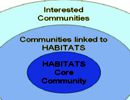
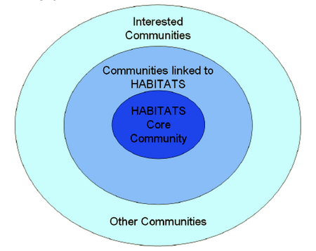 This means that while the main community platform is used, this platform is not the only relevant platform. Instead, other communities augment the main platform; some of them directly linked to the project, some of them with different connections to the project, some of them communities that are thematically related and others that are just interested in the social validation initiative of the HABITATS project.
This association of related communities represents the HABITATS Learning Community Space which is “owned and stirred” by the community. In addition to creating a community network of different layers of involvement and expertise, one of the main benefits can be found in the fact that users don’t necessarily have to join another group but can still participate remotely through their favourite platform or already existing networks.
If stronger interest is sparked, the core community can be joined in order to participate more thoroughly. One of the basic tools for creating a flow of information is using RSS feeds. Other strategies, especially involving community interaction, will be explored in the development process of the community.
Habitats Architecture Design
In Habitats we are using RM-ODP framework that will be integrated with the Model Driven Architecture (MDA) approach, which allows to define the system through an abstract schema, independent from implementation tools and techniques. The relation of all these five viewpoints could be described by the following schema.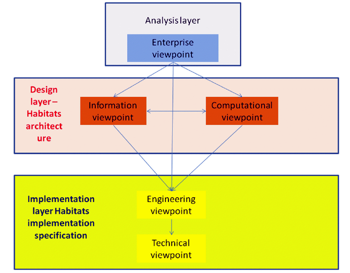
The Enterprise viewpoint of the architecture design is focused on the analysis of pilot scenarios and the definition of a limited numbers of generic use cases that are implemented to support basis functionalities required by more scenarios, but also supporting the process of data and metadata harmonisation based on outputs from WP3.
The Information viewpoint is focused on basic data and metadata sets, which could be shared among different scenarios and also will be focused on data and metadata related to HABITATS and INSPIRE specification. It is also focused on common infrastructure being accessible through Reference Laboratory.
The Computational viewpoint is focused on generic components, which could be reused for more scenarios and which will be some basic parts of the infrastructure. Already here we extend the basic principles of INSPIRE, GMES and GEOSS and add some new functionalities related to data management and updating.
The Engineering viewpoint defines a generic scheme, which can be reused for all pilot implementations and which could be modified for different scenarios. Also this viewpoint is platform independent.
The Technical viewpoint defines basic architecture modifications for single scenarios and suggests potential technical implementation. This solution is really basic definition and will give more option of implementation. Concrete implementation will be modified during the implementation and validation process.
Habitats Generic Services
Habitats identified the following possible services at each of the HABITATS pilots:
1. Management of natural resources
Wild Salmon Monitoring (IE)
La Palma Protected Marine Area (ES)
Hiking Trip Planner (IT)
Natural Environment – Augmented Reality (ES)
Economic activities
Sheep and Goat Herd Management (IT)
Economic activity at marine coastal benthic habitats (LV)
National policy
Czech National Forest Programme (CZ)
Habitats Data Types
Basic types of data recognized by Habitats pilots can be found in the following table.
| Data type | Description | Examples of data | How data are used | How are data accessible |
| Reference data | Reference data are data, which are coming from other systems, and which are not changed inside of HABITATS | Topographic maps, Pan European data sets, administrative borders, cadastre, orthophotos, | Data are primarily used for visualisation, in some tasks they could be used also as background data for analysis (could define areas of analysis, buffers, etc.) | Data could be stored locally, or they could be accessible using Web Services (Web Mapping Services for visualisation, Web Feature Services or Web Coverage services for data analysis) |
| Satellite imagery | Data coming from Earth observation, which are used for analysis and visualisation | SPOT IMAGE, Quick Bird, MODIS (Aqua and Terra) | Data are primary used for data analysis, partly for visualisation | Primary data will be accessible through external catalogues using Web coverage services |
| In-situ observation | Data measured by sensors and stored in databases | Meteorological data, quality water measurement | Data are used for analysis (including temporal) and partly for visualisation. Usually visualisation is necessary using graphs etc. | Data from sensors are usually stored in database and then are accessible through services like Sensor Observation Services, or Web Processing Services |
| Terrain measurement | Data collected in the field using specific measurement equipment | GPS measurement, geometrical measurement, photography with positioning etc. | Data are validated and then used for updating of existing data, next analysis or visualisation | Data are accessible from equipment in proprietary formats or using Web services |
| User edited data | Specific data layers, where groups of people could on line edit data and attributes | Point of interests, user collected data about objects, user observation | Data are validated and then used for updating of existing data, next analysis or visualisation | Data are stored in database using system middleware, accessible could be using web services |
| User derived data | Results of analysis of previous types of data | Image classification, extrapolation from sensors | Data are used for reporting and visualisation | Data are stored on server (often temporally) and are accessible using Web services |
Habitats Networking Architecture
The HABITATS Networking Architecture has the goal to define a system able to ensure the interoperability and security of provided data and services. In particular, since the integration with the INSPIRE initiatives is needed, it is based on:
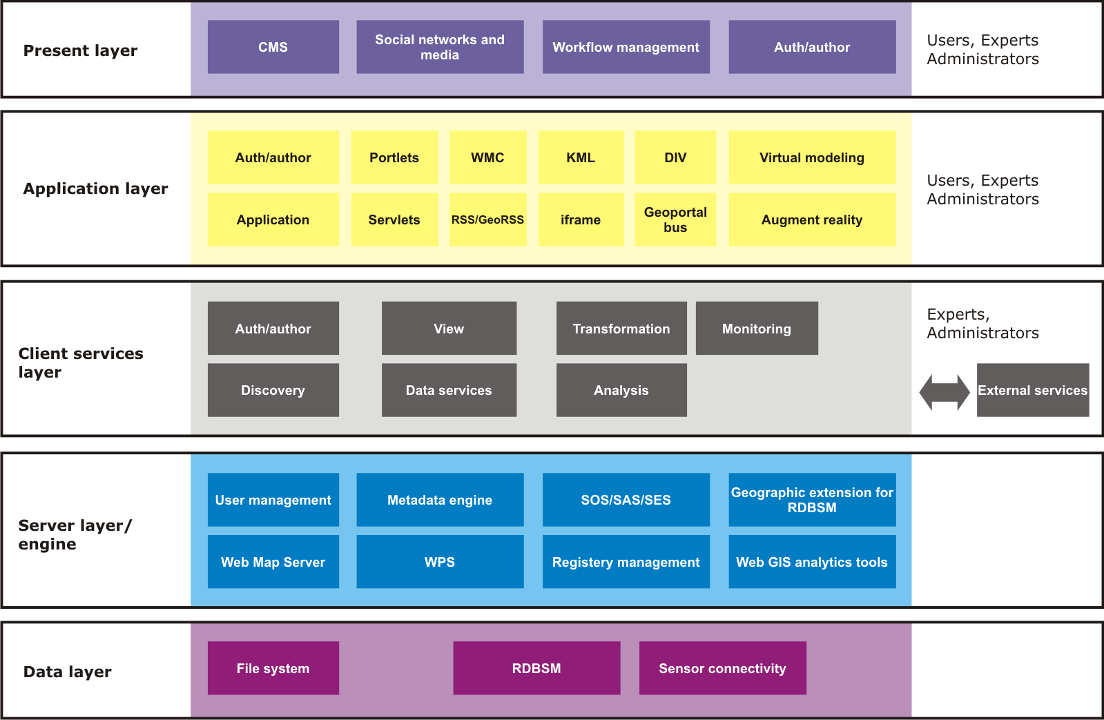
Habitats proposes the view of the system as a set of functional components (or blocks) that communicate through defined interfaces. The system is configured as an architecture made of levels or functional layers:
The basic scheme is in the following figure.
The first set of HABITATS networking services have been implemented on the HABITATS Reference Laboratory (RL) geoportal platform. This acts as a client of the seven HABITATS pilots and provides a very rich set of cross-pilot, inter-regional and enabling services and tools that will be validated by users on the basis of concrete implementations in next phase of the project.
The HABITATS RL provides the common services and tools, and acts as a clearing house for such data, based on cross pilot use cases. The following functionality is required and is being developed for use in phase 2 of the project:
The following cross-pilot themes are identified, where common sharing of data and networking services will be important to all of the HABITATS pilots:
Directive 2007/2/EC of the European Parliament and of the Council of 14 March 2007 establishing an Infrastructure for Spatial Information in the European Community (INSPIRE). [Online]. Available: http://eurlex.europa.eu/JOHtml.do?uri=OJ:L:2007:108:SOM:EN:HTML.
Habitats deliverables available at http://www.inspiredhabitats.eu/
