
 The first line in the Mission Statement for the European Spatial Data Infrastructure Network (ESDIN) project is ‘To become a bridge over troubled geospatial data’. This statement sums up the situation quite well but it needs some elaboration in terms of what the troubles are and how the bridge is being built! 1Spatial is the only UK technology provider in ESDIN. They are helping the consortium to develop best practice for geospatial data management and are working collaboratively with a large number of national mapping agencies, universities and EuroGeographics as the project co-ordinator. (Image: Dave Lovell – l,Steven Ramage-r).
Introduction
The ESDIN project, co-funded by the European Commission (EC) sets out to tackle practical elements of the INSPIRE directive (Infrastructure for Spatial Information in Europe). It will address the INSPIRE challenges by testing the theory of integrating National Spatial Data Infrastructures (NSDIs) to provide Europe with a framework of geographic reference information or in other words a European Spatial Data Infrastructure. When presenting at the project kick-off meeting in Paris in September 2008, Krister Olson from the European Commission stated that ESDIN had received high marks in the EU scoring system because of the broad coverage and accessibility of the expected results.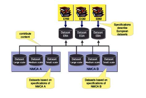 From a collaboration perspective, one way to share information across communities is through common protocols, for example, rules and rules-based processing. This is by no means new in the geospatial world. Indeed it is not new in the EC. RAISE (Rigorous Approach to Industrial Software Engineering) was developed as part of the European ESPRIT II LaCoS project in the 1990s. It consists of a set of tools based around a specification language (RSL) for software development. It has been adopted by the research and training centres of the United Nations University. So the rules based community already stretches beyond the EU. The comparison would be to develop rules in XML across the ESDIN best practice community.
Short overview
ESDIN stands for the European Spatial Data Infrastructure best practice Network. It will help Member States, candidate countries and EFTA States to prepare their data and maintenance processes for INSPIRE Annex I data themes and improve access to them. Specifically the project will:
As mentioned the INSPIRE Directive provides the legal instrument, including a timetable, for the creation of a European Spatial Data Infrastructure which is to be based upon the NSDIs in Member States. Implementing Rules defining technical arrangements for Data, Metadata, Network Services,
Data-sharing and Monitoring and Reporting, which Member States must adhere to, are currently being developed. Before adopting the implementing rules it is a fundamental requirement that the proposed implementing rules are validated in practice to confirm that they are fit-for-purpose. In addition to technical challenges, the new infrastructure will require improved business processes and will promote changes in how information flows within the data provider organisations and from them and Value Added Resellers to end users.
Methodology
Harmonised and maintained pan-European data for some of the INSPIRE Annex I themes already exists at small scales but it is not fully ‘interoperable’, it is not maintained in the most efficient manner and does not meet the increasingly demanding requirements of users.
Through organisational development and better implementation of existing technology it is possible to improve the interoperability of, and cost efficiency with which, the existing datasets are maintained and improve access to other reference themes at different levels of detail.
The ESDIN solution will ensure that the experience of each Member State of Europe and EFTA countries, in the development of their NSDIs and implementation of ‘state-of-the-art’ technology, is shared and exploited in best practice networks of National Mapping and Cadastral Agencies, technology providers, academics,
Value Added Resellers and users to significantly raise the prospects of success for the European Spatial Data Infrastructure. It will result in the provision of data for a number of INSPIRE Annex I themes at a range of scales, from a European view down to a local view. The project will also assess the suitability of this information as a basis for linking to other information themes (INSPIRE Annex ll-lll).
Current situation
European NMCAs have a decade of experience of data harmonisation on a European level with their products EuroGlobalMap (EGM), EuroRegionalMap (ERM) and EuroBoundaryMap (EBM). They have extensively collected user requirements for these products and developed the specifications according to the identified requirements, taking the feasibility and the heterogeneity across the different countries into account.
 Proposed approach
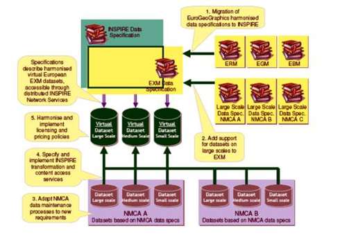
Although INSPIRE is scale independent, scale is still an important issue for both suppliers and users and so needs to be addressed in data specifications by identifying 3 different levels of detail or scale resolution: large scale corresponding to the original or base scale resolution, medium scale corresponding to the EBM/ERM scale resolution (100k-250k) and small scale corresponding to the global scale resolutions like EGM. Building on existing capacity, the experience gained during the development of the existing pan-European products and drafts of the INSPIRE Implementing Rules and data specifications for the Annex l themes, the project will execute the high level tasks discussed below.
In a first phase, the existing product specifications are migrated into the framework of the draft INSPIRE specifications – creating the “ExM” data specification. This specification will conform to the relevant INSPIRE specifications for Annex I themes, i.e. it will be adapted during the course of the project to reflect new versions of the INSPIRE specifications until these are adopted.
Achieving interoperability of data within a theme, between themes, across borders, for different applications and at different resolutions will require some basic components of interoperability being put in place, including services capable of transforming data and providing access to the data, such as; transformations to European data specifications, providing common semantics, support for multi-lingual aspects, transformation of coordinates (to common coordinate reference systems), generalisation (from ‘large’ to ‘small’ scales) and edge-matching (to address inconsistencies at national borders). This project aims to develop, test and implement these.
1Spatial will provide candidate business rules, for example for edge matching (as per the description in Annex B. Edge Matching is a complex area that is important for cross-border harmonisation activities, this is obviously important in the context of INSPIRE with so many European Member States as stakeholders, each with their own datasets and data maintenance regimes.
There are six recommendations in Appendix B of the Data Specifications Reference, D2.6 – Methodology for the Development of Data Specifications). This defines automated methods for edge matching and advocates the need for further collaboration on the rules to match objects when the distances are small. In addition, significant collaboration would be needed to carry out automated operations to derive the solution described in Figure 43 of the same document.
Unless one of the datasets is declared to be of ‘gold standard’, the solution depicted could be based on an error in the dataset, 1Spatial’s Radius Studio product 2 can be used to address such issues.
In addition to data maintenance support around edge matching and other areas like incremental updating, 1Spatial will be lending its considerable expertise to NMCAs and other consortium members, being specifically involved in a number of work packages relating to:
Data quality evaluation – for assessing the level of conformance of existing data to INSPIRE rules, contributing to the feasibility assessment for the reuse of existing NMCA data within ESDIN
Generalisation capabilities – to enable NMCA data to be readily and conveniently remodeled for reuse at alternate scales through web services. Several 1Spatial customers already using their generalisation solutions are involved in ESDIN, e.g. IGN Belgium, IGN France and KMS Denmark
The project will also address the challenge of ‘business interoperability’. Across Europe there are a number of different business models and associated pricing and licensing policies. Management of intellectual property rights, with simple data licensing, digital geo-Rights Management providing fast and easy user access to data, will be important components of the proposed solution delivered in this project.
Quality of data is also a prime concern of users and there is therefore a need to establish a standard approach to reporting data quality in a manner understood by users and for a range of data. This project will therefore prepare guidelines for the creation of discovery metadata and data evaluation for the providers of reference information and develop a quality model based on best practices at the data providers in Europe and on international standards.
Challenges with INSPIRE Annex l data specifications testing
In September 2008 there was a Call for Proposals (CfP) from the SDI Co-ordination Team for INSPIRE at the EC’s Joint Research Centre. The aim of the CfP was to engage industry players to participate in the testing of the draft INSPIRE data specifications for Annex l data themes.
This was part of the communication during that process: “The testing of the draft INSPIRE Data Specifications is an integral part of data specification development, and supplies important information about the technical feasibility and the cost-benefit considerations. This information will be used to shape the Implementing Rules on interoperability of spatial data sets and services, as required in Art 7(1) of the Directive.
The Implementing Rules, once adopted, will become law in the EU Member States. We have started the organisation of testing the draft data specifications related to Annex I data themes, which covers coordinate reference systems, geographical grids, geographical names, administrative units, addresses, cadastral parcels, transport networks, hydrography, and protected sites.”
As a registered Spatial Data Interest Community and via ESDIN 1Spatial responded to the CfP to provide in-kind contributions (software and manpower). The purpose of 1Spatial’s involvement being to help INSPIRE stakeholders assess if the testing was possible using SCOTS technology. This also means determining what costs would be involved to undertake transformations from national datasets to INSPIRE data specifications and to achieve compliance at the same time.
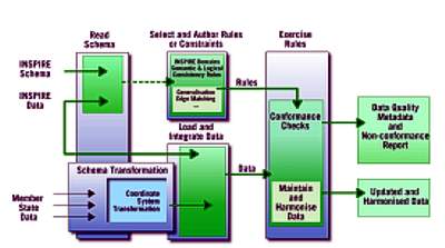
1Spatial is working with a number of European Member States to put together an SDI Conformance Model. At the time of writing this article the conformance model is still being developed, but the outline approach can be seen below. It is an open approach to data validation and conformance checking based on user-defined business rules. The business rules can represent data specifications; such as those from various INSPIRE data themes or Service Level Agreements, in a general business context.
Data conformance or a quality measure can be expressed in % terms, depending on the conformance of the data against the business rules. The results of conformance checks can be published as ISO19115/ISO19139 metadata to a metadata catalogue (OGC CS-W) for audit and discovery purposes. The candidate SDI conformance model is below..
Figure 3 represents a generic approach for taking national data sets and running a series of conformance checks to produce a quality report around ISO quality measures, such as logical consistency and completeness.
Figure 4. represents the SDI conformance model in the INSPIRE context. This approach allows data to be presented, to Radius Studio, the spatial rules engine, using the application schema of the INSPIRE Data Specification. Use of class and attribute renaming, class refactoring and inheritance are used as appropriate. It also provides formal testing of the relative coverage and semantic correspondence of the two schemas.
Radius Studio will also be used to author constraints from the INSPIRE Data Specification, e.g. referential and spatial integrity between links and nodes, stated directly in terms of the INSPIRE conceptual model. These constraints can be grouped together to form a standard common rule set, which encapsulates the requirements for data to conform to the INSPIRE data specifications. This rule set can then be used to validate any national data which is capable of being transformed to the INSPIRE data model. Using the standard rule set and the transformed data, the level of conformance of the data against the rules can be measured.
Radius Studio produces standard structured reports (XML) on conformance levels. Additional synthetic or manually altered data can be used to demonstrate the effectiveness of the tools at detecting logical corruptions, if needed.
Conclusion
As it stands, INSPIRE, as the European SDI, is purely theoretical. ESDIN will work on best practices for integrating the National Spatial Data Infrastructures (NSDIs) of Member States to provide the European SDI. This will ascertain if users can access and share geospatially referenced data for a variety of date themes at a European or local level.
With so many NSDIs at different points of development across Europe, data varies quite significantly in quality, coverage, content and structure. Aggregating data across Europe from different sources, different themes and at multiple resolutions through a services-based approach is a concept yet to be implemented in practice on any significant scale. The work in ESDIN will provide a practical and pragmatic approach to addressing these issues.
In their paper from September 2008, Collaboration networks as carriers of knowledge spillovers: Evidence from EU27 regions, Hoekman, Frenken and van Oort present the concept that the geography of innovation traditionally concentrates on localised knowledge spillovers, yet neglects collaboration networks as a means to access knowledge outside the region. ESDIN could be such a collaboration network. The presented results from this paper were suggested to be useful for two science base sectors, i.e. biotechnology and the semiconductor technology:
“The spatial diffusion of knowledge and its effect on innovation is of major importance to ensure productivity growth and to improve the welfare of nations. As knowledge is hard to appropriate it generates benefits to other agents through several spillover mechanisms. Understanding the geographical structures that underlie these spillover benefits is necessaryfor any evidence-based innovation policy to stimulate Europe’s transformation towards a knowledge-based society.”
The final element of the ESDIN Mission Statement states ‘Stimulate the development, use and re-use of European digital content in the global network’. As a best practice network ESDIN will be invaluable for INSPIRE stakeholders. From a global perspective it should also promote European digital content and provide some inspiration for other SDI initiatives across the globe.
1Spatial via their SDI conformance model and ESDIN project involvement is working as a European SME to help support and drive this activity. If ESDIN is successful in its objectives to work with project members and industry reference groups then hopefully knowledge spillover will benefit Europeans as a whole and support the geospatial industry at the same time.
Steven Ramage is Business Development Director at 1Spatial Group, based in the United Kingdom. Dave Lovell is Executive Director at EuroGeographics, based in France.
ESDIN Project Partners
• EuroGeographics – Project Co-ordinator
• 1Spatial (United Kingdom)
• Bundesamt für Eich- und Vermessungswesen (BEV, Austria)
• Bundesamt für Kartographie und Geodäsie (BKG, Germany)
• Finnish Geodetic Institute (FGI, Finland)
• Geodan (Netherlands)
• Helsinki University of Technology (Finland)
• IGN Belgium
• IGN France
• Institute of Geodesy, Cartography and Remote Sensing (Hungary)
• Interactive Instruments (Germany)
• Kort & Matrikelstyrelsen (KMS, Denmark)
• Lantmäteriet (Sweden)
• National Agency for Cadastre and Real Estate (Romania)
• National Land Survey of Finland
• National Technical University of Athens (Greece)
• Statens Kartverk (Norway)
• University of Edinburgh (United Kingdom)
• University of Münster (Germany)
Other information:
