 The European Space Agency’s innovative Biomass satellite is now fully commissioned, opening free access to a powerful new stream of data that promise a step change in our understanding of forest dynamics and their role in regulating the global carbon cycle.
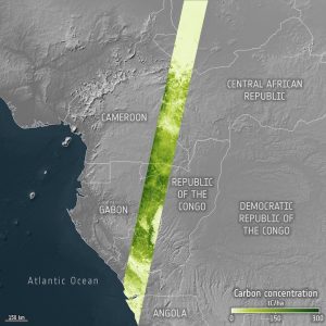
This image from the Biomass mission depicts a transect of estimated forest carbon content, in tonnes per hectare, across Gabon and the Republic of the Congo, extending to Cameroon and the Central African Republic. Carbon is derived from the Biomass mission’s measurements by multiplying above-ground estimates by a factor of 0.5 (roughly, half of the weight of wood is carbon, the other half is water).
Image Credit: ESA
