 Science teams at NASA and the French space agency Centre National d’Études Spatiales (CNES) have released the first-ever global estimate of river discharge and suspended sediment, as observed from space, marking a new milestone in our ability to understand one of Earth’s most fundamental systems.
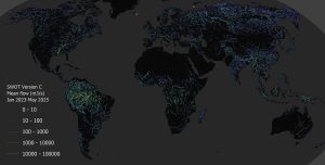
Developed using data from the Surface Water and Ocean Topography (SWOT) satellite, this resource makes it possible to estimate river discharge, defined as the volume of water flowing per second at a given point along the river, as well as suspended sediment concentration in every river on Earth wider than 160 feet (50 meters). This information could help people manage freshwater resources more efficiently, predict floods more reliably and forecast crop yields more accurately.
Image Credit: (NASA/JPL/UMass)
