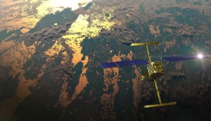
The international Surface Water and Ocean Topography (SWOT) satellite, as shown in this illustration, is the first global mission surveying Earth’s surface water. SWOT’s high-resolution data help scientists measure how Earth’s bodies of water change over time. (Credit: CNES)
As part of the long-standing partnership between NASA and Google, NASA worked with Google Arts & Culture and artist Yiyun Kang to create an interactive digital experience around global freshwater resources titled “A Passage of Water.” This immersive experience leverages data from the Gravity Recovery and Climate Experiment (GRACE) satellites and new high-resolution data from the Surface Water and Ocean Topography (SWOT) mission to illustrate how climate change is impacting Earth’s water cycle.
A digital version of “A Passage of Water” was released online on Nov. 30, 2023, ahead of the beginning of the United Nations’ Climate Change Conference of Parties (COP 28) in Dubai, United Arab Emirates. Google also will host a physical installation of the visualization project in the Blue Zone at COP 28.
For six decades, NASA has been collecting data on Earth’s land, water, air and climate. This data are used to inform decisionmakers on ways to mitigate, adapt and respond to climate change. All of NASA’s Earth science data is available for scientists and the public to access in a variety of ways.
“NASA studies our home planet and its interconnected systems more than any other planet in our universe,” said Karen St. Germain, director of NASA’s Earth Science Division. “‘A Passage of Water’ provides an opportunity to highlight the public availability of SWOT data and other NASA Earth science data to tell meaningful stories, improve awareness, and help everyday people who have to make real decisions in their homes, businesses and communities.”
A collaboration between NASA and the French space agency CNES (Centre National d’Études Spatiales), SWOT is measuring the height of nearly all water on Earth’s surface, providing one of the most detailed, comprehensive views yet of the planet’s freshwater bodies. SWOT provides insights into how the ocean influences climate change and how a warming world affects lakes, rivers and reservoirs.
