 A joint project of the French Government and Capture4Cad is using laser scanners from the Leica Geosystems’ BLK autonomous reality capture portfolio to create a comprehensive 3D model of the Citadelle de Besançon, France, a UNESCO World Heritage Site, while allowing visitors to immerse themselves in the area’s rich history. Digitalizing the citadel will help preserve it and enable more visitors to experience its history through augmented reality.
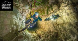
Capture4Cad had to navigate several challenges while collecting the data, including the sheer size of the citadel. Many areas are inaccessible, and the team had to avoid disruption to visitors and animals onsite. Using a range of scanners, Capture4Cad was able to cover the whole site within a tight timeframe. The Leica BLK2FLY autonomous flying scanner captured the towering ramparts, sheer cliffs, roofs and facades of the citadel. The versatile Leica BLK ARC was steadily lowered 120 meters into France’s deepest well to thoroughly map the well shaft. The BLK ARC was also mounted to Boston Dynamics’ autonomous robotic carrier to independently map the grounds of the citadel. In the underground tunnels, the handheld Leica BLK2GO scanner provided uninterrupted scanning on the move.
