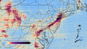
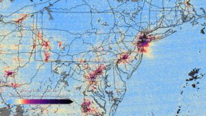
This pair of images shows nitrogen dioxide levels over the DC/Philadelphia/New York region at 12:14 p.m. (top) and 4:24 p.m. (bottom) on Aug. 2, 2023, as measured by TEMPO. (Credit: Kel Elkins, Trent Schindler, and Cindy Starr/NASA’s Scientific Visualization Studio)
NASA released the first data maps from its new instrument launched to space earlier in 2023, which now is successfully transmitting information about major air pollutants over North America.
From its orbit 22,000 miles above the equator, NASA’s TEMPO, or Tropospheric Emissions: Monitoring of Pollution, is the first space-based instrument designed to continuously measure air quality above North America with the resolution of a few square miles.
Observations by TEMPO will significantly improve studies of pollution caused by rush-hour traffic, the movement of smoke and ash from forest fires and volcanoes, and the effects of fertilizer application on farmland. In addition, TEMPO data will help scientists evaluate the health impacts of pollutants and aid in the creation of air-pollution maps at the neighborhood scale, improving understanding of disparities in air quality within a community. Data will be shared with partner agencies that monitor and forecast air quality, such as the Environmental Protection Agency and the National Oceanic and Atmospheric Administration.
The science mission is a collaboration between NASA and the Smithsonian Astrophysical Observatory (SAO) in Cambridge, Mass.
The first pollution maps released by NASA from the mission show concentrations of nitrogen dioxide gas from pollution around cities and major transportation arteries of North America. TEMPO measures sunlight reflected and scattered off Earth’s surface, clouds and atmosphere. Gases in the atmosphere absorb the sunlight, and the resulting spectra are then used to determine the concentrations of several gases in the air, including nitrogen dioxide.
