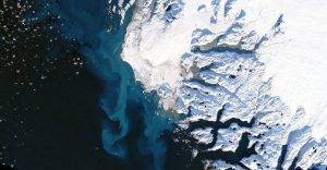
Meltwater from Greenland glaciers like the one pictured can contribute significantly to sea-level rise. Sentinel-6 Michael Freilich monitors the height of Earth’s oceans so researchers can better understand the amount and rate of sea-level rise. (Credit: NASA Earth Observatory using Landsat data from USGS)
On March 22, 2022, the newest U.S.-European sea-level satellite, Sentinel-6 Michael Freilich, became the official reference satellite for global sea-level measurements. This means that sea-surface height data collected by other satellites will be compared to the information produced by Sentinel-6 Michael Freilich to ensure their accuracy.
Launched from Vandenberg Air Force Base in November 2020, the satellite is continuing a nearly 30-year legacy started by the TOPEX/Poseidon satellite, which began its mission to measure sea-surface height in the early 1990s. A series of successor satellites have carried on the effort since then, with Sentinel-6 Michael Freilich being the most recent. Its twin, Sentinel-6B, is slated to launch in 2025.
