That GIS products and technologies will adopt 3D for visualization and analysis is a foregone conclusion. Possibly the biggest clue that geospatial 3D is going to be perceived in the future as just another flavor of the map interface is the simple one-click toggle between Google Maps and Google Earth that was introduced a couple of years ago. What snuck in as a cool widget now appears in countless consumer-focused online interfaces powered by Google. That capability has been copycatted by others and is slowly entering the vernacular of the traditional GIS and Design product vendors.
Some still suggest that 3D is just a gimmick and others wonder if 3D capability in the GIS industry should be isolated to a few specialty applications that focus on the application of 3D analysis to geospatial problems. It’s likely that the ultimate use of 3D in geospatial technology is neither a gimmick nor a specialist capability. The adoption of 3D in the mass consumer market along with improved availability of 3D data, increasing importance of the merger of GIS and BIM, and the need to meet the expectations of end stakeholders are all driving the adoption of geospatial 3D and bringing closer together the GIS and Design industries.
Consumer Expectations
In two completely mundane experiences, entertainment and driving, 3D has become an expected part of the consumer experience. The average citizen in most developed economies has become trained by ubiquitous consumer technologies to expect that 3D digital experience is possible.
According to consumer research organizations, two thirds of US households play video games and the time spent playing video games for US consumers continued to escalate even through a down economy reaching eight hours a week last year for the average gamer. Although not all games are 3D, the segment of the market that has moved to 3D typically has trained millions of software users to navigate and make judgments in two key modes of 3D digital experience and navigation, fully immersive environments and birds-eye isometric views. Nintendo has even recently released a 3D mobile gaming platform that doesn’t require glasses. Anyone with $250 can experience 3D games at any time and gamers are even driving the sales of 3D TVs.
Rent a car with a GPS and you have the ability to navigate by alternating between 2D and 3D mode at any point on your journey. Similar navigation devices are widely available for fishermen, hikers, and pilots. The 3D visuals found in navigation devices today are not highly representative of the real world, but have become an accepted mode for conveying contextual information. Acquisitions such as Navteq’s purchase of Pixelactive, the maker of a 3D world creation tool, signal that the data and hardware vendors behind the navigation industry are likely to adopt more 3D, not less.
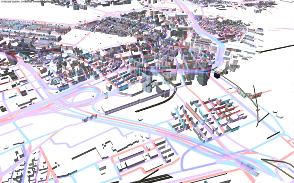
Simulated traffic analysis in Autodesk Project Galileo using GIS data from the city of Boston. Data was provided by the Office of Geographic Information (MassGIS), Commonwealth of Massachusetts Executive Office of Environmental Affairs.
Availability of 3D Data
The biggest hurdle to the early GIS industry was convincing end stakeholders that expensive investment in digital data collection to produce electronic maps was worthwhile. Today, with the proliferation of 2D GIS and the consumer adoption of 3D in the mass market, that questions appears to be solved. Information-rich, graphical data of all kinds has become mission critical to governments and to building and infrastructure-oriented service providers. The hurdle facing widespread adoption of 3D is consumer access to cost effective, appropriate data to meet local needs.
Microsoft, Google, Navteq, Teleatlas and many other companies have been amassing large quantities of 3D data for years with a mixed record of being able to reliably monetize distribution of the data. Their data sets are suitable for games and even reliable navigation but the mass data collectors often don’t have the right level of detail required for infrastructure and building projects. Change management for such large data sets can also be expensive and not meet the timeline requirements of projects.
Today, we’re finally approaching the right conditions for the commoditization of 3D data. In addition to these large banks of 3D data, surveying instrumentation, ground and aerial-vehicle mounted LiDAR, and potogrammetric reconstruction of 3D digital models of real world assets all offer solutions that are increasing in availability and decreasing in expense.
Relevance of GIS and BIM Integration
The need for technology to improve workflows in individual projects for new construction pushed the Design world move to 3D as an integral component of processes such as Building Information Modeling (BIM). BIM traditionally dealt with the finite scope of a single, possibly highly complex, project. The lack of requirement for contextual information limited the drive to capture as-built information about the real world in the vicinity of a proposed asset.
Globalization, climate change, and insufficient infrastructure are causing governments and commercial entities to work on larger projects while considering impacts of projects on the environment, population density, and the distribution of utilities and goods. Today’s projects need to be concerned about the context within which a project is executed as well as the detail inside the assets that are being built or renovated.
Tools like sunlight irradiance modeling, water flow modeling, and wind flow analysis require 3D information to achieve accurate results and we are seeing that architecture and engineering professional increasingly need access to integrated GIS and BIM data. Intelligence about the environment of a project influences not only the exterior shape of assets to do things like mitigate noise and preserve views, but contextual information influences the inner design and configuration of buildings and infrastructure. Conversely, detailed features of individual assets, such as the locations of handicapped accessible doors and elevators, influence topologies of transportation and telecommunication networks and campus layouts.
The need for better integration of extrinsic and detailed properties of infrastructure and building projects is driving technology vendor such as Autodesk, Bentley, Esri, and others to explore better tools for sharing information between BIM and GIS. The natural graphical medium for BIM is 3D due to the complexity of interweaving components of infrastructure projects. The GIS market is waking up to realize that 3D is also a critical capability necessary to provide information that will influence and guide the construction of more sustainable, less congested, and better performing buildings and infrastructure.
 Data was provided by the Office of Geographic Information (MassGIS), Commonwealth of Massachusetts Executive Office of Environmental Affairs.
Winning Work and Faster Approval
Few planners, engineers or architects pay for 2D or 3D software for its own sake. In the end, they are focused on selling plans and proposals to their end stakeholders, whether those are citizens concerned about change in their city or private parties paying for a project directly. 2D maps and CAD drawing are hard to read and require specialty skills to correctly use and interpret.
Graphical renderings in plans and proposals help to convince the end stakeholder that proposed work will meet behavioral and aesthetic requirements while obeying schedule and cost limitations. The typical member of the general public does not immediately associate a purple dotted line with a road, for example. However, put a 3D rendering in front of a person and they immediately achieve an impression of the behavioral and aesthetic properties and relationships of assets within the scene. In 3D visuals, a person doesn’t have to interpret a gray volume as a building because they already have been looking at 3D buildings their whole life and immediately ‘know’ the object is a building.
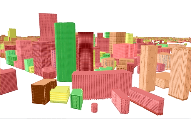
Simulated neighborhood sustainability visualization in Autodesk Project Galileo using GIS data from the city of Boston. Data was provided by the Office of Geographic Information (MassGIS), Commonwealth of Massachusetts Executive Office of Environmental Affairs.
Ongoing Research
All of the large vendors in the geospatial and engineering markets are experimenting with technologies that can be interpreted to be bridging the gap between GIS and BIM through the use of 3D. ESRI has greatly improved the access to 3D in the ArcGIS platform and demonstrates examples of 3D GIS even inside buildings. Bentley shows demonstrations of interoperability between CAD and CityGML, an open standard for 3D graphic and information exchange about geolocated urban assets.
At Autodesk, we are exploring the integration of 3D, geospatial information, and BIM in technologies focused on architecture and engineering workflows. Autodesk Project Vasari can be used to sketch small campuses and 3D scenes which can then be analyzed with geographically and astronomically correct solar models. Autodesk Project Galileo allows the user to build and explore large 3D models containing hundreds of thousands of assets that derive from GIS, engineering, and 3D model data. Both projects can be downloaded freely from Autodesk Labs and user feedback and download volume has been outstanding for both.
3D will successfully proliferate through the geospatial market because 3D helps non-specialized viewers intuitively grasp the behavior and performance of projects and assets in a way that is not possible with 2D. Consumers are already acclimatizing to a technology market in which 3D capability is ubiquitous and data is increasingly available. Engineering and planning technology vendors are on the cusp of a dramatic change that will push them to deliver integrated solutions that merge GIS and BIM technologies.
