This merger combines complementary marine technology products and services to better serve U.S. and international clients with integrated capabilities.
DAYTON, Ohio (Feb. 3, 2022) — Woolpert has acquired eTrac Inc., a vessel-based hydrographic survey and marine technology firm that conducts custom and integrated marine services for projects across the U.S. and its territories. These services include collecting and processing hydrographic survey and bathymetric mapping data for coastal mapping, navigation safety and nautical charting, high-resolution multibeam sonar data for shipping channel dredging and pipeline inspections, underwater imagery and aerial lidar data for change analysis, and vessel positioning and monitoring.

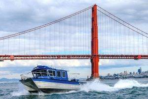
This merger combines the hydrographic survey and multibeam sonar expertise of eTrac with Woolpert’s aerial topographic, bathymetric and geospatial capabilities to deepen service offerings, leverage inherent synergies, achieve operational efficiencies and extend geographic reach. Photo courtesy of eTrac, a Woolpert Company
eTrac is headquartered in San Rafael, Calif., and has offices in La Porte, Texas; Port Orchard, Wash.; and Wasilla, Alaska. eTrac will become part of Woolpert’s geospatial sector and will expand to serve clients throughout the U.S. and around the world.
Woolpert Vice President and Maritime Solutions Market Director John Gerhard said this merger combines the hydrographic survey and multibeam sonar expertise of eTrac with Woolpert’s aerial topographic, bathymetric and geospatial capabilities to deepen service offerings, leverage inherent synergies, achieve operational efficiencies and extend geographic reach. It also unites eTrac’s fleet of survey vessels with Woolpert’s 49 manned and unmanned aircraft.
“We have partnered with eTrac for years. We know their people, admire their work and understand how we make each other and the data better,” Gerhard said. “By marrying our complementary marine technology products and services, we gain the tools to comprehensively support the needs of our global clients today and to develop the geospatial solutions of tomorrow. We have already begun collaborating—seeing whether a project is better served via a plane or boat, which sensor will be most cost-effective, etc.—and this is just the beginning.”
Like Woolpert, eTrac was founded as an engineering and survey company. While Woolpert grew to develop integrated architecture, engineering and geospatial (AEG) capabilities, eTrac carved out its niche in vessel-based hydrographic services. Both have retained that fundamental, problem-solving perspective. This has led the firms to not only deliver geospatial services but to develop products where needed solutions did not yet exist.
“Woolpert is very technology-forward, investing in the future rather than playing catchup, and that is how we’ve always operated as well,” said Michael Mueller, CEO and founder of eTrac. “We have our line of marine products and systems, and Woolpert has its new topo-bathy sensor system, all of which were designed to address specific client needs. The fact that Woolpert has established a maritime lab to further hydrographic and bathymetric research and development efforts internationally really sealed the deal for us.”
Woolpert President and CEO Scott Cattran said this acquisition further strengthens Woolpert’s position as a leading provider of global geospatial services.
“We continue to invest heavily in firms that provide progressive solutions for our clients. Between our firms and through our extensive industry partnerships, we are now collecting, processing and integrating data from outer space to the bottom of the ocean—strengthening our industry leadership in marine, maritime and coastal mapping services,” Cattran said. “We are now one of a few select firms around the world that can deliver this wide a swath of vital geospatial data, and we are the only ones who can support it with integrated AEG expertise. We are excited to welcome eTrac to our growing Woolpert family.”
About Woolpert
Woolpert is the premier architecture, engineering, geospatial (AEG) and strategic consulting firm, with a vision to become one of the best companies in the world. We innovate within and across markets to effectively serve public, private and government clients worldwide. Woolpert is an ENR Top 150 Global Design Firm, recently earned its sixth-straight Great Place to Work certification and actively nurtures a culture of growth, inclusion, diversity and respect. Founded in 1911 in Dayton, Ohio, Woolpert has been America’s fastest-growing AEG firm since 2015. The firm has more than 1,600 employees and 60 offices on four continents. For more, visit woolpert.com.
About eTrac Inc.
eTrac Inc. was established in 2003 as a hydrographic survey, vessel positioning and marine instrumentation firm. eTrac has quickly grown to include over 40 employees in several offices along the coastal United States, including the San Francisco Bay area, Anchorage, Pacific Northwest and the Gulf of Mexico. The firm has earned a strong reputation among many sectors of the hydrographic industry including government agencies and private industry. Its equipment fleet has also grown to include geophysical survey vessels as well as several ultra-portable, shallow water survey craft. eTrac is committed to continual reinvestment in industry leading equipment and knowledgeable staff to complete multibeam, singlebeam, sidescan, subbottom, mobile lidar and water-level surveys required by our clients. For more, visit etracinc.com.