 You do not have to be in the geospatial industry to be amazed at images of recognizable locations. Everyone is curious to see a satellite image of his or her home or other areas of interest. In addition, an increasing number of organizations are also realizing the value of imagery, when combined with other geospatial information and business data. Once a novelty, accessing an aerial or satellite image online is one of the many tangible benefits of the increasing development and integration of geospatial and web technologies.
You do not have to be in the geospatial industry to be amazed at images of recognizable locations. Everyone is curious to see a satellite image of his or her home or other areas of interest. In addition, an increasing number of organizations are also realizing the value of imagery, when combined with other geospatial information and business data. Urban planners have relied upon imagery to monitor green space; civil engineering companies readily utilize imagery to monitor highway development projects; environmental consulting firms use imagery to evaluate the effects of residential development on a river channel. Once a novelty, accessing an aerial or satellite image online is one of the many tangible benefits of the increasing development and integration of geospatial and web technologies.
While satellites produce vast quantities of imagery, their relatively short lifespan of capturing data prohibits illustrating extensive change. In addition, because of large file sizes, there are also challenges in quickly serving satellite imagery. For those interested in more detailed information on an area of interest, it is often a struggle to find multiple images tracking ecological or man-made change over an extensive time.
HistoricAerials.com Collectively Captures Yesterday and Today
Recently, NETR Online, a division of Nationwide Environmental Title Research, LLC launched www.Historicaerials.com , making aerial photographs illustrating the changing landscape readily available. Handling projects from 20 to 650 frame aerial photographs, Nationwide Environmental Title Research began operating in 1993 and developed their online identity through NETR Online in 1999. NETR Online is a portal for real estate public records and research information for property, deeds and mortgage copies, tax records, parcel maps, assessment records and public records nationwide. Their primary focus has been to provide historical research information on the environment and make data accessible via the Internet.
HistoricAerials.com provides free online access to historic and current aerial photographs, enabling users to view photographs from the 1930s through recent years. By combining several years worth of imagery as separate layers in the same application, property sites may be researched in less time with greater efficiency. With multi-year comparison tools, users may quickly recognize historical changes in a specific parcel of land or the surrounding area of a property. In addition to providing a tool for curious homeowners, HistoricAerials.com also provides data and a perspective that is otherwise elusive for those in academic research, resolving legal disputes, tracking genealogy, planning real estate development and much more.
 |
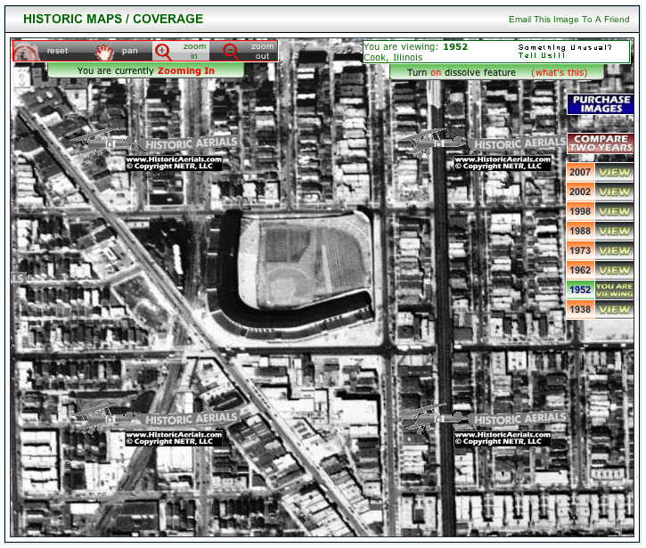
| Mouse over this 1952 image of Wrigley Field in Chicago to reveal the same spot in 2002. |
The aerial photos included on HistoricAerials.com have been amassed by several government organizations, including the United States Geologic Survey (USGS), Department of Natural Resources (DNR), United States Department of Agriculture (USDA), as well as numerous private organizations. Utilizing Geographic Information Systems (GIS) and photogrammetry technologies, Historicaerials.com has synthesized many disparate datasets to create a revolutionary way to view aerial photography over time.
Previously, these photographs were stored in large books and archived at federal, state and county offices, as well as warehoused at private companies. Many of these photographs did not include the entire city or county, and often were flown at different altitudes and at irregular intervals.
Processing Solutions for Visualizing Change
LPS, a photogrammetry solution from ERDAS, provides the flexibility needed to power the workflow behind preparing images for HistoricAerials.com. This includes the flexibility to work with incomplete data sources and irregular projects NETR Online often encounters. With seven seats of LPS, this production mapping system is used heavily for digital orthophoto production. Implementing LPS as their primary production tool in 2004, NETR Online estimates that they have orthorectified approximately 100,000 images through this software package.
According to Brett Perry, CEO, NETR Online, “LPS is essential, it is the primary piece of our processes. Basically, after getting the data, we open it in LPS.” Jim Hall, also at NETR Online added, “We then run all the necessary processes, and the data comes out of LPS and then goes directly on our website.”
Following orthophoto production, NETR Online then uses LPS and ERDAS IMAGINE to prepare the images for their website by producing a single image mosaic per project area. The final image mosaic product may then be compressed in preparation for online delivery as well.
Handling some of the older projects (e.g. 1930’s) involves managing several challenges. Some of the images are scans of contact prints and not original film. In the 1980s, the originals of many of these images were scanned, without any record of their resolution. The originals were then printed, and the paper copies were rescanned for digitizing. Likewise, camera calibration reports can often be difficult to come by for older sets of photography, which NETR Online can reconstruct in LPS. NETR Online has also encountered a number of images without a record of flight instrumentation, elevation or the scan resolution or camera information.
 |
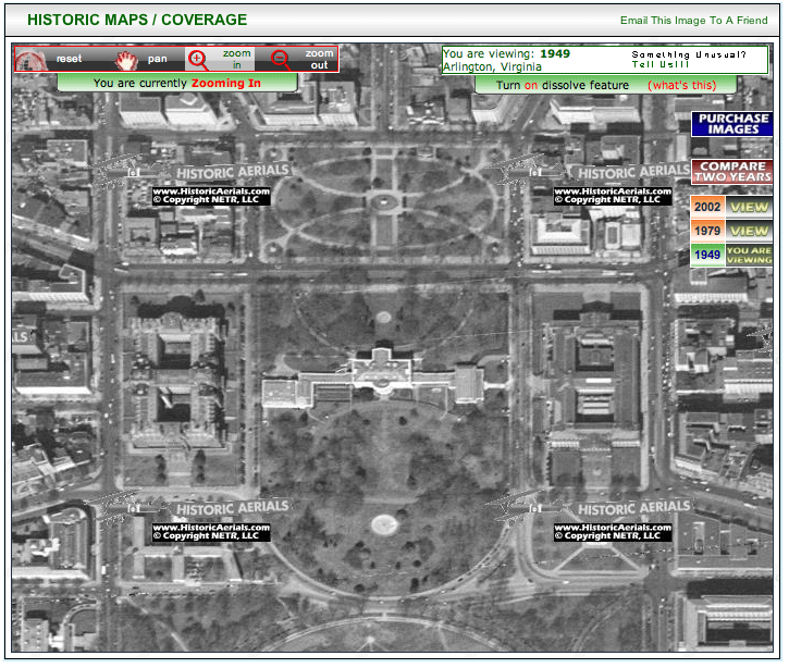
| Mouse over this 1949 image of the White House to compare to how it looked in 2002. |
Accessing the Changes
HistoricAerials.com currently has approximately 100 terabytes of data storage space. As the demand for imagery rapidly increases, HistoricAerials.com is prepared to continue increasing the areas they are covering. Recently, the site experienced 60,000 hits in a single day. While there is a great deal of discussion on personal blogs, HistoricAerials.com is experiencing this interest without any concerted marketing efforts. While their focus is to incorporate imagery for multiple years for the entire U.S., the site may also even expand to feature imagery from other countries.
HistoricAerials.com enables a wide variety of users to benefit from quickly accessing the changing landscape. For example, train hobbyists may now analyze the changes in old routes and depots, while other interested users may nostalgically identify old fire towers or schoolhouses. For those agriculturally minded, cranberry farms or other types of crops grown may also be identified by the timeframe, along with changes in the soil. Already, those in the government and the real estate and insurance industries are recognizing the value of tracking the changing land and speculating what the future may hold. As users continue to discover this unique tool, its relevance will be further understood, for both those geospatially curious, and those needing to track change for business processes.
Jason Sims is marketing communications specialist at ERDAS Inc.; E-mail: jason.sims at erdas.com.