-->
Tuesday, December 20th, 2016
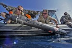
The Chinese seizure of a U.S. underwater drone in waters near The Philippines is raising international concern as well as highlighting the growing strategic and tactical significance of unmanned underwater vehicles (UUVs). According to a statement from Pentagon spokesman Peter Cook, “Using appropriate government-to-government channels, the Department of Defense has called upon China to immediately

Wednesday, July 9th, 2014
Many reports in the Chinese media have indicated that Alibaba, China’s largest e-commerce site that is on an investment spree, will team with State-owned China North Industries Group to promote the commercial uses of the Beidou navigation system. The investment has been reported at 1 billion yuan ($160 million) according to Dazhihui News Agency.
Tuesday, December 20th, 2011
After several months of preparation, a new Sino-UK Geospatial Engineering Centre has been launched formally in Beijing. It will be run jointly by NASG, China’s National Administration for Survey, Mapping and Geoinformation — through its academic arm the Chinese Academy of Survey and Mapping (CASM) — and The University of Nottingham. The Centre will develop geospatial
