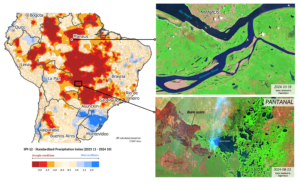
The SPI-12 index for the period November 2023 to October 2024, showing extremely dry conditions in large parts of Brazil. On the right, Sentinel-2 satellite images showing the drainage of the Rio Negro and the Amazon River near Manaus, fires and burnt areas in the Pantanal wetland system.
As Europe grapples with unprecedented floods and Asia faces the fury of typhoons, a different crisis is unfolding in South America: record droughts. Geographers Elzė Buslavičiūtė and Dr. Laurynas Jukna from Vilnius University’s Department of Geography and Landscape Management shed light on alarming conditions in the Amazon basin, where river levels have plummeted to historic lows and fires rage through the world’s largest wetland system.
Due to climate change, drought—defined as an extended period of significantly below-average precipitation—is becoming an unrelenting reality. In the Amazon region, the typically dry season from June to October has reached unprecedented severity this year. While ground-based data often informs drought assessments, satellite technology plays a crucial role in offering a broader perspective.
Satellite data combined with ground measurements reveal that arid conditions have spread across Brazil, Bolivia and Paraguay. The SPI-12 index for November 2023 to October 2024 indicates that many areas in the Amazon now exhibit SPI values below 2, categorising them as experiencing extreme drought. Brazil’s National Disaster Monitoring and Early Warning Centre (CEMADEN) identifies the northern, mid-western and south-eastern regions as the hardest hit. This crisis is exacerbated by the El Niño phenomenon and an unusually warm North Atlantic, with the current drought’s impact stretching over twice the area affected during the last major El Niño in 2015-2016.
