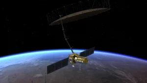
Pictured in this artist’s concept, NISAR marks the first time the U.S. and Indian space agencies have cooperated on hardware development for an Earth-observing mission. Its two radar systems will monitor change in nearly all of Earth’s land and ice surfaces twice every 12 days. (Credit: NASA/JPL-Caltech)
Once it launches in early 2024, the NISAR radar satellite mission will offer detailed insights into two types of ecosystems—forests and wetlands—vital to naturally regulating the greenhouses gases in the atmosphere that are driving global climate change.
NISAR, short for NASA-ISRO Synthetic Aperture Radar, is a joint mission by NASA and ISRO (Indian Space Research Organisation), and, when in orbit, its sophisticated radar systems will scan nearly all of Earth’s land and ice surfaces twice every 12 days. The data it collects will help researchers understand two key functions of both ecosystem types: the capture and the release of carbon.
