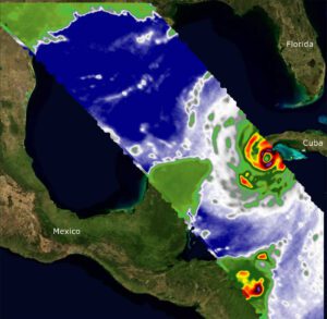
 Two recently launched instruments designed and built at NASA’s Jet Propulsion Laboratory in Southern California to provide forecasters data on weather over the open ocean captured images of Hurricane Ian on Sept. 27, 2022, as the storm approached Cuba on its way north toward the U.S. mainland.
COWVR (Compact Ocean Wind Vector Radiometer) and TEMPEST (Temporal Experiment for Storms and Tropical Systems) observe the planet’s atmosphere and surface from aboard the International Space Station.
This image combines microwave emissions measurements from both COWVR and TEMPEST. White sections indicate the presence of clouds. Green portions indicate rain. Yellow, red, and black indicate where air and water vapor were moving most swiftly. Ian’s center is seen just off of Cuba’s southern coast, and the storm is shown covering the island with rain and wind.
Image Credit: NASA/JPL-Caltech
