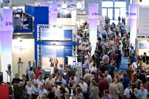
 INTERGEO was held in Karlsruhe, Germany last week under sunny skies allowing for the 15,000 in attendance to participate in both indoor and outdoor displays of the latest geospatial technologies developed by international manufacturer’s from 30 countries. At 25,000 square meters, INTERGEO remains one of the largest geospatial events on the planet.
Held annually, the event, sponsored by the organiser, the Deutsche Verein für Vermessungswesen e.V. Gesellschaft für Geodäsie, Geoinformation und Landmanagement (German Association of Surveying German Society for Geodesy, Geoinformation and Land Management (DVW is shifting gears. This shift is exemplified by the myriad of displays that are not solely surveying related. There were numerous vehicles loaded with laser instrumentation visible around the show floor. A significant number of vendor’s were displaying map making technologies, both digital and non-technologies were evident.
 Intermap Technologies have forged new partnerships in Europe as evidenced by their participation in different areas with partners. The company continues to offer the highest resolution topographic mapping for Europe – NEXTMap Europe. Their 3D road vectors are now being used in the automotive industry for predictive safety applications. Announced at the show was AccuTerra, the new iPhone based application for users to plan their outdoor activity.
Leica Geosystems, a Hexagon company, announced their new Leica Viva, a new generation surveying system that combines GNSS receivers, controllers and total stations along with software into an integrated system. With a slogan “…let us inspire you,” this technology represents the future in terms of ongoing convergence that is flexible. Collectively, it also means users outside of surveying alone will likely be participating in it’s use.
SOKKIA was nbotable for their Formula One display exhibit at the show. The F1 racer doubled as a presentation booth enabling the audience to visit with and learn about company’s products while sitting inside the vehicle, which measured 10 meters by 5 meters in size. In the late 1980s, the Noranda Mining Company in Canada developed a system for measuring cavities underground. Optech – The Lidar Company, purchased the rights to the technology, a portable revolving unit for underground monitoring and measurement. The company also announced a new ILRIS-HD High Density Scanner.
erdas has the new ERDAS IMAGINE 2010 about to hit the market. I used version 4 of this software to write a thesis and have to say, this really is a step up from the previous version. I spoke to Mladen Stojic, SVP of Product Management and Marketing who explained hwo the product is being developed and the logic behind the new erdas IMAGINE – APOLLO connection. He explained the professional aspects of the products and how they result in tangible value to end users. Stojic see’s  the market as requiring someone who understands the technologies, even though not all people need to know the details. I share his sentiment that the idea is not to ‘dumb down’ technology, but instead, to make it available in ways previosuly not seen readily. The new IMAGINE will go a long way to realising that potential.
ESRI was in attendance and a large contingent from Kranzberg were displaying the latest of what is termed ‘A Complete Geographic Information System’ – the new ArcGIS 9.4. There were several displays of ArcGIS Online technology and that company is continuing to offer a wide range of support and services that are GIS related throughout the country. It was also one of a growing number of company’s providing dual English-Deutsch language materials at INTERGEO. While this is growing, there is still a need to recognise the international audience by other company’s. At V1 Magazine we know that many people develop applications which are exportable, particularly in Germany and China.
TerraModeler is a terrain modeling package and calls Finland home. Some people may not be aware though that Terra Modeler reads in different XYZ data and can generate TIN models or surfaces. The product is also used within the Bentley MicroStation product line and is able to perform vector processing. This software can also edit terrain points and includes volume calculations.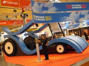
Lenne3D (www.lenne3d.com) cauught my eye. This software generates visualisations for parks and landscapes. The quality of the renderings coming from this software are interesting.
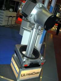
The company also has a Flora 3D digital plant library. Carlson Survey 2010 was on display. Carlson is noted for providing a full line of CAD related and GIS functional products. They are an Autodesk authroised Developer and a IntelliCAD Authorised Consortium Member. The ULTRACAMXp was on display at INTERGEO. Vexcel, now working as a Microsoft company is providing some of the highest quality imagery on the planet through the use of this aerial camera. The camera is sleek, no denying that as the style and design are simple and attractive. But performance matters, and this camera can output a an image 17,310 X 11,310 pixels easily. The NIR image is smaller. These cameras are constantly under development for improvement and now yield the same GSD at a lower flying altitude.
MAGELLAN has released the ProFlex 500 Base Station. Connectivity includes NTRIP and Direct IP capabilities and the unit may be upgraded to combined GPS/GLONASS operation. The product is compatible with MAGELLAM receivers including ProMark and the MobileMapper. It features RTK technology for high-performance. INTERGEO was loaded with GPS related technology as many surveying related companies are now integrating GIS and CAD functionality into the work flows of these instruments.
Autodesk LandXplorer Studio Professional is now available as is LandXplorer Server. I spoke with Peter Rummel of Autodesk about these products and other AEC topics. He informed me that that company is now working to integrate AEC and Geospatial units together. This is not wholly surprising as even LandXplorer signals – the market is converging and workflows are integrating. RSS Remote Sensing Solutions GmbH is creating some high definition ‘3D RealityMaps’ – you might be interested to stop in and see them.
 I was intrigued by the K2 Company’s product GEOVision 3. It is used for 3D CAD/GIS data collections and is best described as a mobile GIS. It talks with a WLAN connection and has a high quality design. This unit contains lots of access ports of all types for sharing data and transferring information. Definiens was at the show and I sat down with Ralph Humberg who explained how that company is developing a newe user community that will be oriented toward satisfying the needs of IT, applications building and the users. The idea holds great promise for building a library of rules that other users can obtain for use at a time when, seemingly, few people want to know details. Alas, the best softwares always include professional talents somewhere along the line. Definiens definitely wins the award for coolest post card – ask them about it.
I’ll be writing about more company’s who attended INTERGEO this year in the day’s ahead. The event is loaded with information. But start planning for next in Cologne (how did the southwest get so lucky to years in a row?). The 2010 event will come fast. Hope to see you there.
See additional Blog Posts Here and Here
