
imagina 2010 was recently held in Monaco. The event included a 3D track together with an architecture and landscape-territory track this year , both of which proved highly successful. Several leaders in the 3D city, building and construction design space were present. Lively discussions and debates about the current future possibilities for evolving 3D technologies and applications were included. A 3D Ethics Charter was signed at the event. Jeff Thurston reports on the first of a two-part summary of the event.
imagina 2010 was held February 3-5 in Monaco. This event was extended this year to include a Architecture, Urbanism and Territory Management track which was wholly compatible with and augmented the traditional visualisation tracks involving cinema and video gaming. The 3D track centered upon issues relating to urban and green design. The theme was timely and world renowned architect Jean Nouvel presented several examples of his work including the Ferrari Factory in Modena – Italy, apartments in SoHo – New York, Genoa Trade Fair – Genoa, Italy and several of his designs that have either to be built, were declined or have been delayed at the moment.
These include La Defense – Paris, GazProm City – Russia, Dubai Opera House – Dubai and Mussee Gugenheim, Guadalajara. He indicated that 3D is important to his work for many reason including landscape design, fascades and orientations.
He said that a design for the Environmental Education Centre in Holland was developed with direct relationship to the topography, with the building becoming part of the landscape.
Nouvel discussed the various ‘approaches’ to design including algorithmic types that depended upon scripts and mathematical equations to create contemporary designs.
These would include genetic types of designs that mimic nature. Indeed one could see this approach present in much of his work that included fractal designs and crystal-like representations.
This type of architecture represented a step away from pre- fabrication he said, and was based on botanics and natural elements. The ‘systems’ approach was more in line with ecosystems and the dialogue expanded to include the environment.
The concept of Green Design would fall into the later category, while efficiency was also considered and the design complexity was evident. He spoke about networks and the flow of building patterns, an example being Ecosystema Urbano – Spain. Others included Solar Tower Energy – Australia, a design that was based on managing solar energy. “Digital 3D technology is not something we guess about now, it has matured and is available now and has been for twenty years,” Nouvel said.
Anne Asensio is vp Dassault Systemes Design Experience and I sat with her asking about that company’s presence into the Green Building and Design space. She indicated that Dassault Systemes brings a wealth of experience and knowledge about design to the green – environmental field since it is a systems based company that has learned (and experienced) a wealth of knowledge about processes through design projects that it re-applies to new projects and applications.
That results in a high degree of reuse and cross-purposing of content, creativeness and imagination in the design experience. “We believe that 3D has a major role in the green design experience,” she said. “This role is not developing, it has been present a long time and we see it daily in many green design projects at Dassault Systemes that we are involved in.” To Dassault Systemes 3D is here and now and will only grow.
Pierre Jaboyedoff is a research and development engineer at Sorane SA and he explained the value of 3D through example. In one case a project had lighting issues in the design and through 3D these issues were solved. He showed how balancing energy in 3D helped to design a naturally ventilating stairwell.
The CSTB was represented by Eric Lebegue who spoke on the topic of building trade and the need for identifying ways to involve more people into the digital design of buildings and construction. “We have a highly heterogenous environment with low interoperability between technologies,” he said. He specifically pointed to the work being dome on Industry Foundation Classes (IFCs) and some of that agency’s projects including CLIMAWIN, ELODIE AND OPTIMI. Lebegue says builders are moving toward an integrated approach where systems are prevalent and collaboration is high.
“Each of these systems will have high performance levels and users will be able to choose standardized products for inclusion into building systems.” Some of this work coincides with the BuildingSmart initiative. He suggested that certain building tasks will trigger the use of systems in the future and help to automate the building process. “The real question becomes a challenge once this starts to happen because it is the adjacent spaces that will need to be realised as this process occurs.”
Each of the tracks was followed by a Q&A and I have to say that these were some of the best that I have attended. The audience remained in place and their wide ranging experiences contirbuted toward a lively discussion – one that the organisers left ample time for, which is seldom appreciated in most conferences. Topics ranged from discovering new ways for making collaborative data available, including standards and privacy related issues. It was mentioned that transparent tools are needed that conform to traceability, assessment and reliability checks.
One person noted that savings due to 3D need to be documented better. There was a sense that money needs to be invested in 3D for communication as compared to seeing communication as a budget item to be cut. “Why collect, design and create then not follow through on talking and representing?”
There was speculation that design in architecture could in fact lead toward updating of geographic information system (GIS) databases.
There was also mention of the need to talk about 3D quality. “We need 3D without explanation,” someone said. Other quesions realted to neogeography and public participation in the building and design process. Some surveys have shown that 60% of the people in project design neighbourhoods are looking for ways to participate in 3D design projects. I found this fascinating. While the industry has been developing general social tools, the creation and availability of public design tools is yet to come.
Dassault Systemes presented on the topic of their upcoming City Life 2.0 product which is expected in early 2011. The idea behind the product follows through on the company’s approach to projects, namely, to integrate complex systems from a multitude of experiences. In this case social tools would coincide with the development. Energy would become part of the equation for establishing balanced, sustainable cities and it is expected that Dassault Systemes would include several types of tools within the project. They also spoke about the development of a series of 3D tools for participation and design. Based on their development, the company expects the path for development will include :
Dassault Systemes has explored the business model for creating a single digital model. While a city needs a digital city model, different providers (with purposes) will need to access that model. It was mentioned that software toolkits could be sold through the model to create a series of services. When I step back to consider this, that approach would tie neatly to the standards being developed for IFC and some of the ongoing CityGML work being done. Individuals and organisations could not only participate, but sell specialised tools within a framework of digital city models. Looking for an analogy? Think about airlines sharing booking systems – then extrapolate it.
Eric Piccuezzu of Dassault Systemes spoke about the partnership with Gehry Technologies and the need to have tools that enable higher productivity. He explained what is termed ‘Building In Life’ and the ‘BIMification’ currently evident but also lacking in collaborative tools.
This was impacting the industry in a negative light he felt and making it difficult to attract younger people into the building and construction industry. The lack of skilled labor being a constantly voiced thought around the world. “Sustainable design will include and depend upon compliance with new regulations, new simulation and product life management.”
Piccuezzu neatly identified how the building strategy of the Dassault Systemes coincides with the overall green and sustainable strategy built upon community, content and services. The Gehry Technologies initiative was built on the notion that 3D can solve incredible problems.
It began in 2003 with Dassault Systemes and Gehry technologies signing a partnership. This resulted in CATIA in 2004, the leading 3D design tool from the company. It has been estimated that 90% of all building projects are over budget and these tools are used to reduce that inefficiency. The challenge is to more fully optimise the design process. The use of 3D is viewed with many benefits including:
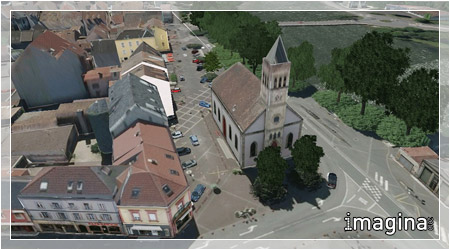
Christian Pere, a lecturer at L’ENSAM Cluny presented on that engineering school which has 8 different centres. At Le Project Gunzo in Burgundy there are 5000 people. This location was the center of Europe in the middle ages and had the highest church in the 12th century. It was destroyed in 1799 with only 8% of the original structure standing today. It is now managed by the French National monument authority and receives over 100,000 visitors annually. Pere said that a new initiative began in 2002 to create a virtual simulation of the church. Work focused on volumes and lighting. By 2010 the Gunzo Project was ready to celebrate 1000 years in a ceremony and the project nearly complete.
This involved the use of Trimble GPS equipment for digitisation and location finding along with laser related work. Fragments of stone were scanned and positioned in a new 3D model and high resolution pictures were taken by digital camera from balloon. Engineers, geographers and historians worked together to reconstruct the site in exact detail together with textures in the visualisation. The work was completed using CATIA.
The Thursday session turned attention toward 3D City & Territory Modelling: Issues and Perspectives. GIS was used discussed by Jean Francois Coulais of the same institution in terms of the system of tools being used in design processes. ArcGIS allowed for scales and historical documentation to be included into workflows. At one point people broke away from the GIS paradigm he mentioned, instead preferring to work alone. “Now it appears that collaboration and the integration aspects of GIS are bringing people together once again.”
Coulais spoke about hand drawings in the development of city designs. “We want to work in different scales for different purposes,” he said. “It is important to work with history. Memory – hisotry – identity and function.”Jacques Soignon, Director of City Parks for the City of Nantes, France presented on the interesting work in that city. He described the GPS located trees and vegetation and suggested that this work had great potential leading toward the development of ecological services and biodiversity management as it impacts legislation.
Towards that end Coulais described the Skyline web browser for using historical information, including archaeological information. There are questions remaining though, such which thematic layers to include, scale issues and different types of models all operating within one historical or city environment. To meet these challenges he suggested more interoperability, working toward standards for historical information, integrity of data, need for virtual tools inside buildings and files that are lightweight.
“Perhaps we need enhanced reality beacons,” he said. These being screens that assist to guide us. At CLUNY the institution has become the laboratory for experimentation. The work there has led toward tablets that people carry through historic sites, each filled with advanced reconstructions of those sights and changing pictures through the use of gyroscopes. Henri Pornon of leti Consulting pointed out that GIS was likely part of the 3D future due to it’s integrative nature and new ways of GIS would likely arise in the future.
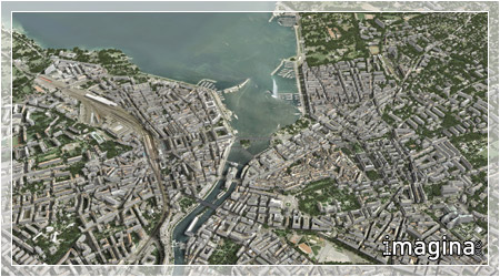
The final day saw a larger number of presentations on 3D Modelling for areas. Methods and results were presented and Jean Marie Fournillier, Director of Urban Development for the City of Lyon presented on very high definition modelling for the Pays de Montbeliard. Lyon includes 57 communities, 51,500 ha of land management with 80% of it’s 1.3 million inhabitants located within Rhone. Applications tied together in the mangement infrastructure include water, sewage, highways, parking, documents and housing information. All information is RGE ZVD compatible and are updated in 6 month time periods.
Included are 16×24 pixel imagery, DTM and 1:200 topographic plans. Lyon has been working on a digital city framework for nearly 20 years Fournillier said. The city uses ArcInfo, AutoCAD Map 3D, MapGuide and several Open Source software including MapServer, Postgresql, ERMapper and Safe Software’s FME. “People in our region are demanding more 3D,” Fournillier said. Working with the company SpaceEyes, 3D models are now being developed for the Carre de Soie neighbourhood and 6 sq. km have been developed to date.
————————————————————————————————————————
Next Week read Part II of the imagina 2010 event on topics related to digital cities, 3D models in government and some of the many private industry company’s in attendance at the event.
More Information:
imagina 2010: Dassault Systems Moving into the Digital City
http://www.vector1media.com/vectorone/?p=4768
