(Heerbrugg, Switzerland, 14 October 2021) Hexagon’s Geosystems division announced today that the HxGN Content Program now offers aerial imagery of England, Scotland and Wales at up to 12.5-centimetre resolution through its partnership with Bluesky International Ltd

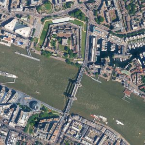
12.5-centimeter resolution aerial imagery of the Tower Bridge in London, England
The addition of Bluesky’s data provides instant access to various datasets of Great Britain:
“Bluesky is a long-standing, trusted partner of Hexagon, and we’re excited to integrate its high-quality aerial imagery into the HxGN Content Program,” says John Welter, President Geospatial Content Solutions at Hexagon. “Through this partnership, Hexagon customers can gain real-world insights of Great Britain for confident analysis and decision-making. The initiative is an excellent example of how we enable our partners to participate in our global program while they serve their local customers.”
“We are delighted to partner with Hexagon on their HxGN Content Program, enabling users around the world to access and stream Bluesky aerial imagery directly into their geospatial applications,” comments Rachel Tidmarsh, Managing Director of Bluesky International. About 229,040 square kilometres of new data were added to the program, and it is now available through the HxGN Content Program’s Data Store for pixel download and streaming via OGC-compliant WMS/WMTS, SOAP, and REST protocols.
The HxGN Content Program offers the largest library of high-resolution 4-band aerial imagery and elevation data across Europe and North America. The data is orthorectified, accurate and available at multiple resolutions. The program follows rigorous acquisition and processing standards to offer high positional accuracy for a variety of applications. The data consistency over large areas enables automatic feature extraction and analytics with AI and machine learning. Flexible data use terms allow users to create derived products.
Further information visit: hxgncontent.com
Hexagon
Hexagon is a global leader in digital reality solutions, combining sensor, software and autonomous technologies. We are putting data to work to boost efficiency, productivity, quality and safety across industrial, manufacturing, infrastructure, public sector, and mobility applications.
Our technologies are shaping production and people related ecosystems to become increasingly connected and autonomous – ensuring a scalable, sustainable future.
Hexagon (Nasdaq Stockholm: HEXA B) has approximately 21,000 employees in 50 countries and net sales of approximately 3.8bn EUR. Learn more at hexagon.com and follow us @HexagonAB.
Bluesky International Ltd.
Bluesky International is the leading aerial survey and geographic data company in the UK and Republic of Ireland producing and maintaining seamless digital aerial photography and height data on a national scale in both Great Britain and Ireland. Bluesky also undertakes bespoke surveys, including LiDAR, for a range of public and private sector clients.