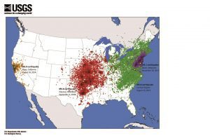
Map of USGS “Did You Feel It?” data shows that earthquakes east of the Rocky Mountains are felt over larger areas than earthquakes in the West.
Why was an earthquake in Virginia felt at more than twice the distance than a similar-sized earthquake in California? Earthquakes east of the Rocky Mountains can cause noticeable ground shaking at much farther distances than comparably sized earthquakes in the West.
A magnitude 5.8 earthquake in 2011 in Mineral, Va., was felt up to 600 miles from the epicenter. Tens of millions of people in the eastern United States and southeastern Canada felt this earthquake.
For comparison, a magnitude 6.0 earthquake in 2014 in Napa, Calif., was felt only as far as 250 miles from the epicenter. Despite the Napa earthquake releasing about twice as much energy as the Virginia earthquake and causing much more damage near the epicenter, it wasn’t felt nearly as far away.
As another example, the magnitude 4.1 earthquake that occurred in December 2017 near Dover, Del., was felt approximately 200 miles from the epicenter. The region that felt this earthquake is about the same size as that of the much larger California event, which released about 700 times more energy.
Scientists are researching a variety of factors that influence regional differences in the intensity and effects of earthquakes. Some of the factors have to do with the nature of the underlying tectonic plates and their geologic history. Others are connected to the size and age of buildings.
Eastern North America has older rocks, some of which formed hundreds of millions of years before those in the West. These older formations have been exposed to extreme pressures and temperatures, making them harder and often denser. Faults in these older rocks have also had more time to heal, which allows seismic waves to cross them more effectively when an earthquake occurs.
In contrast, rocks in the West are younger and broken up by faults that are often younger and have had less time to heal. So when an earthquake occurs, more of the seismic wave energy is absorbed by the faults, and the energy doesn’t spread as efficiently.
Many of the older structures in the East, such as buildings and bridges built before the 1970s, were not designed to endure earthquakes and therefore may not fare well. The recent earthquakes that struck near Christchurch, New Zealand, showed the damage that infrequent earthquakes can do to a region with older structures. With that said, modern buildings are being constructed to newer design standards, and there has been progress in retrofitting many older buildings in the East. In the West, older structures are often retrofitted, and new structures are designed to withstand strong shaking.
Furthermore, smaller structures such as houses could experience stronger and more damaging shaking in the East. Earthquakes in the East tend to cause higher-frequency shaking—faster back and forth motion—compared to similar events in the West. Shorter structures are more susceptible to damage during fast shaking, whereas taller structures are more susceptible during slow shaking.