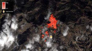
The Satelytics platform empowers oil and gas providers to monitor oil and gas flowlines from their desktop computer, tablet or smartphone.
Methane leaks and explosions are uncommon, but they can be fatal, as witnessed in the April 2017 Firestone, Colo., explosion that killed two men and seriously injured one woman. In May 2017, the Colorado Oil and Gas Conservation Commission issued a Notice to Operators that requires systematic inspection of their inventory of flowlines—active as well as abandoned—by the end of June 2017. Other states (notably California and Pennsylvania) also have taken steps ordering operators to monitor natural gas infrastructure for methane leaks and avoid dispersal of the gas into the atmosphere.
To help in this regard, Satelytics uses satellite data to detect leaks, threats, and right-of-way changes to oil and gas infrastructure, enabling operators to keep tabs on their extraction, storage, and delivery systems utilizing satellite imagery analyzed and delivered via cloud software. Conditions that indicate a fugitive methane emission or oil leak are detectable using remote-sensing algorithms, and reporting software issues alerts to ground crews and operators.
More information about Satelytics services for Colorado oil and gas providers affected by the regulation can be found at https://www.satelytics.com/landing/colorado.