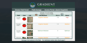
The integration of EOSDA Crop Monitoring and Gradient Crop Yield Solutions. (Credit: Gradient)
In the heart of California’s Central Valley, a groundbreaking agricultural revolution is underway. Gradient Crop Yield Solutions, a subsidiary of The Morning Star company, is leading the charge in transforming the way tomatoes are grown, using cutting-edge ground sensor technology and remote-sensing analytics to optimize irrigation practices.
The satellite imagery provided by EOS Data Analytics has not only propelled their customer base to over 26,000 acres but also saved farmers a remarkable 10-15% in irrigation costs.
Growing tomatoes in California, despite the region’s favorable climate, presents several agricultural challenges. It is continually impacted by water scarcity, with inconsistent irrigation management leading to crop yield losses and impacted plant health.
To address these issues, Gradient Crop Yield Solutions emerged from the dynamic research and development department of The Morning Star company, focusing on improving water-management practices. This transformative journey began on a modest scale, encompassing a mere 1,300 acres in 2018. However, it was the overwhelming interest from growers that necessitated the creation of the Gradient Crop Yield Solutions platform.
By 2019, the company officially took flight, servicing an initial customer base of 6,200 acres. Fast forward to 2021, and Gradient’s reach extended to an impressive 21,000 acres. Today, they proudly serve growers across California’s expanse, spanning from the south to the north, accounting for a total of 26,000 acres.
Eventually, Gradient decided to harness the power of satellite imagery offered by EOSDA Crop Monitoring to obtain a holistic view of the field uniformity. This data allows their farmers to optimize irrigation practices. Jesus Salcedo, Software Engineer at Gradient, explains: “Satellite imagery allows us to monitor different areas without being present in the field. It saves us from the need to consistently visit fields for checks that may not be necessary.”
The result is a 10-15% reduction in irrigation costs, compared to conventional grower-standard methods. It’s a transformation that redefines the farming landscape, demonstrating the positive impact of precision agritech.
